
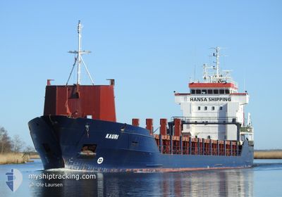
KAURI
General Cargo
Current Trip
DE VIW
| Time Travelled | 3 days |
|---|---|
| Remaining Time | --- |
| Distance Travelled | 590.14 nm |
| Remaining Distance | --- |
| AVG Speed | 10.7 Knots |
| MAX Speed | 12.6 Knots |
| AVG Wind | 8.3 knots |
| MAX Wind | 13.2 knots |
| MIN Temp | 10.3°C / 50.54°F |
| MAX Temp | 15.2°C / 59.36°F |
| Draught | 6.1 m |
| Position Received | 3 h, 17 m ago |
Current Position
| Longitude | 13.69027° |
|---|---|
| Latitude | 54.42550° |
| Status | At anchor |
| Speed | |
| Course | 62° |
| Area | Baltic Sea |
| Station | T-AIS |
| Position Received | 3 h, 17 m ago |
Info
Information
The current position of KAURI is in Baltic Sea with coordinates 54.42550° / 13.69027° as reported on 2024-06-01 07:16 by AIS to our vessel tracker app. The vessel's current speed is 0 Knots
The vessel KAURI (IMO: 9173226, MMSI: 305633000) is a General Cargo that was built in 1998 ( 26 years old ). It's sailing under the flag of [AG] Antigua Barbuda.
In this page you can find informations about the vessels current position, last detected port calls, and current voyage information. If the vessels is not in coverage by AIS you will find the latest position.
The current position of KAURI is detected by our AIS receivers and we are not responsible for the reliability of the data. The last position was recorded while the vessel was in Coverage by the Ais receivers of our vessel tracking app.
The current draught of KAURI as reported by AIS is 6.1 meters
Weather
| Temperature | 15.4°C / 59.72°F |
|---|---|
| Wind Speed | 13 knots |
| Direction | 55° NE |
| Pressure | 1012.6 hPa |
| Humidity | 89.4 % |
| Cloud Coverage | 56 % |
Featured Company
Last Port Calls
| Port | Arrival | Departure | Time In Port |
|---|---|---|---|
| 2024-05-26 19:45 | 2024-05-29 08:53 | 2 d | |
| 2024-05-17 05:59 | 2024-05-17 23:06 | 17 h | |
| 2024-05-06 14:39 | 2024-05-07 16:33 | 1 d | |
| 2024-05-05 13:20 | 2024-05-06 07:20 | 17 h | |
| 2024-05-02 20:07 | 2024-05-04 17:56 | 1 d | |
| 2024-05-02 07:47 | 2024-05-02 19:54 | 12 h | |
| 2024-05-01 18:28 | 2024-05-02 07:40 | 13 h | |
| 2024-05-01 15:11 | 2024-05-01 18:11 | 2 h | |
| 2024-04-22 12:55 | 2024-04-24 21:06 | 2 d | |
| 2024-04-21 16:11 | 2024-04-21 16:14 | 3 m |
Most Visited Ports (Last year)
| Port | Arrivals | |
|---|---|---|
| 10 | ||
| 4 | ||
| 4 | ||
| 2 | ||
| 2 | ||
| 2 |
Last Trips
| Origin | Departure | Destination | Arrival | Distance | |
|---|---|---|---|---|---|
| 2024-05-18 00:06 | 2024-05-26 22:45 | 1868.06 nm | |||
| 2024-05-07 19:33 | 2024-05-17 06:59 | 1584.46 nm | |||
| 2024-05-06 10:20 | 2024-05-06 17:39 | 94.87 nm | |||
| 2024-05-04 20:56 | 2024-05-05 16:20 | 175.44 nm | |||
| 2024-05-02 22:54 | 2024-05-02 23:07 | 8.58 nm | |||
| 2024-05-02 10:40 | 2024-05-02 10:47 | 10.48 nm | |||
| 2024-05-01 21:11 | 2024-05-01 21:28 | 4.48 nm | |||
| 2024-04-24 23:06 | 2024-05-01 18:11 | 763.16 nm | |||
| 2024-04-21 18:14 | 2024-04-22 14:55 | 181.08 nm | |||
| 2024-04-20 22:02 | 2024-04-21 18:11 | 139.87 nm |
Events
| Time | Event | Details | Position / Dest | Info |
|---|---|---|---|---|
| 2024-06-01 07:22 | Status Changed | Default At anchor |
54.42552 / 13.69025
DE VIW
|
Speed: Course: 62° |
| 2024-06-01 07:16 | Status Changed | At anchor Default |
54.42550 / 13.69027
DE VIW
|
Speed: Course: 64° |
| 2024-06-01 07:16 | OUT of Coverage |
54.42550 / 13.69027
Baltic Sea
DE VIW
|
Speed: Course: 243.3° |
|
| 2024-06-01 07:07 | Status Changed | Default At anchor |
54.42550 / 13.69028
DE VIW
|
Speed: Course: 60° |
| 2024-06-01 05:58 | Status Changed | At anchor Default |
54.42537 / 13.69037
DE VIW
|
Speed: Course: 56° |
| 2024-06-01 05:49 | Status Changed | Default At anchor |
54.42536 / 13.69041
DE VIW
|
Speed: Course: 51° |
| 2024-06-01 04:55 | STOP Moving | 4.83 nm, South East of MUKRAN |
54.42542 / 13.69033
DE VIW
|
Speed: Course: 61° |
| 2024-06-01 04:42 | Status Changed | At anchor Under way using engine |
54.42582 / 13.69127
DE VIW
|
Speed: 1.1 kn Course: 63° |
| 2024-06-01 01:41 | Change Sea Area | German part of the Baltic Sea Danish part of the Kattegat |
54.56570 / 14.56797
Baltic Sea
DE VIW
|
Speed: 11.3 kn Course: 252.5° |
| 2024-05-31 19:01 | Detected in Sea | Danish part of the Kattegat |
55.41210 / 16.22568
Kattegat
DE VIW
|
Speed: 11.4 kn Course: 228.7° |