
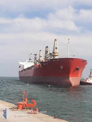
KING M
General Cargo
Current Trip
TR IZMIT
| Time Travelled | 10 days |
|---|---|
| Remaining Time | --- |
| Distance Travelled | 2514.80 nm |
| Remaining Distance | --- |
| AVG Speed | 10.1 Knots |
| MAX Speed | 13.1 Knots |
| AVG Wind | 11.2 knots |
| MAX Wind | 23.7 knots |
| MIN Temp | 24.7°C / 76.46°F |
| MAX Temp | 31°C / 87.8°F |
| Draught | 9.2 m |
| Position Received | 11 h, 10 m ago |
Current Position
| Longitude | 76.53171° |
|---|---|
| Latitude | 8.22597° |
| Status | Under way using engine |
| Speed | 10.6 Knots |
| Course | 321.8° |
| Area | Laccadive Sea |
| Station | T-AIS |
| Position Received | 11 h, 10 m ago |
Info
Information
The current position of KING M is in Laccadive Sea with coordinates 8.22597° / 76.53171° as reported on 2024-06-02 11:44 by AIS to our vessel tracker app. The vessel's current speed is 10.6 Knots
The vessel KING M (IMO: 9614282, MMSI: 374560000) is a General Cargo that was built in 2012 ( 12 years old ). It's sailing under the flag of [PA] Panama.
In this page you can find informations about the vessels current position, last detected port calls, and current voyage information. If the vessels is not in coverage by AIS you will find the latest position.
The current position of KING M is detected by our AIS receivers and we are not responsible for the reliability of the data. The last position was recorded while the vessel was in Coverage by the Ais receivers of our vessel tracking app.
The current draught of KING M as reported by AIS is 9.2 meters
Weather
| Temperature | 28.2°C / 82.76°F |
|---|---|
| Wind Speed | 11 knots |
| Direction | 312° NW |
| Pressure | 1007.5 hPa |
| Humidity | 74.9 % |
| Cloud Coverage | 100 % |
Featured Company
Most Visited Ports (Last year)
| Port | Arrivals | |
|---|---|---|
| 3 | ||
| 3 | ||
| 2 | ||
| 2 | ||
| 2 | ||
| 2 |
Events
| Time | Event | Details | Position / Dest | Info |
|---|---|---|---|---|
| 2024-06-02 11:47 | Status Changed | Default Under way using engine |
8.23486 / 76.52445
TR IZMIT
|
Speed: 10.6 kn Course: 321.8° |
| 2024-06-02 11:44 | OUT of Coverage |
8.22597 / 76.53171
Laccadive Sea
TR IZMIT
|
Speed: 10.6 kn Course: 321.8° |
|
| 2024-06-02 06:50 | Status Changed | Under way using engine Default |
7.54073 / 77.08942
TR IZMIT
|
Speed: 11 kn Course: 317° |
| 2024-06-02 06:04 | Status Changed | Default Under way using engine |
7.43843 / 77.18869
TR IZMIT
|
Speed: 10.9 kn Course: 315.4° |
| 2024-06-02 05:53 | Status Changed | Under way using engine Default |
7.41540 / 77.21060
TR IZMIT
|
Speed: 11.1 kn Course: 318° |
| 2024-06-02 05:45 | Status Changed | Default Under way using engine |
7.39816 / 77.22636
TR IZMIT
|
Speed: 11 kn Course: 318.4° |
| 2024-06-02 05:12 | Destination Changed | TR IZMIT POLIPORT,TURKEY |
7.32249 / 77.29409
TR IZMIT
|
Speed: 10.5 kn Course: 316.7° |
| 2024-06-02 04:16 | Status Changed | Under way using engine Default |
7.20162 / 77.41191
POLIPORT,TURKEY
|
Speed: 10.6 kn Course: 316° |
| 2024-06-02 03:59 | Status Changed | Default Under way using engine |
7.16767 / 77.44532
POLIPORT,TURKEY
|
Speed: 10.6 kn Course: 315.6° |
| 2024-06-02 03:46 | Status Changed | Under way using engine Default |
7.13859 / 77.47362
POLIPORT,TURKEY
|
Speed: 10.4 kn Course: 316° |