
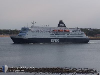
KING SEAWAYS
Ro-Ro/Passenger Ship
Current Trip
| Time Travelled | 1 h, 59 mins |
|---|---|
| Remaining Time | 15 h, 23 mins |
| Distance Travelled | 20.76 nm |
| Remaining Distance | 240.87 nm |
| AVG Speed | 14.5 Knots |
| MAX Speed | 15.9 Knots |
| AVG Wind | 13.9 knots |
| MAX Wind | 16 knots |
| MIN Temp | 14.9°C / 58.82°F |
| MAX Temp | 17.5°C / 63.5°F |
| Draught | 6.2 m |
| Position Received | 24 m ago |
Current Position
| Longitude | 4.03977° |
|---|---|
| Latitude | 52.64415° |
| Status | Under way using engine |
| Speed | 15.6 Knots |
| Course | 313° |
| Area | North Sea |
| Station | T-AIS |
| Position Received | 24 m ago |
Info
Information
The current position of KING SEAWAYS is in North Sea with coordinates 52.64415° / 4.03977° as reported on 2024-06-20 17:00 by AIS to our vessel tracker app. The vessel's current speed is 15.6 Knots and is heading at the port of TYNE. The estimated time of arrival as calculated by vessel tracking app is 2024-06-21 08:47 LT
The vessel KING SEAWAYS (IMO: 8502406, MMSI: 220449000) is a Ro-Ro/Passenger Ship that was built in 1987 ( 37 years old ). It's sailing under the flag of [DK] Denmark.
In this page you can find informations about the vessels current position, last detected port calls, and current voyage information. If the vessels is not in coverage by AIS you will find the latest position.
The current position of KING SEAWAYS is detected by our AIS receivers and we are not responsible for the reliability of the data. The last position was recorded while the vessel was in Coverage by the Ais receivers of our vessel tracking app.
The current draught of KING SEAWAYS as reported by AIS is 6.2 meters
Weather
| Temperature | 14.8°C / 58.64°F |
|---|---|
| Wind Speed | 13 knots |
| Direction | 45° NE |
| Pressure | 1018.3 hPa |
| Humidity | 77.6 % |
| Cloud Coverage | 100 % |
Featured Company
Last Port Calls
| Port | Arrival | Departure | Time In Port |
|---|---|---|---|
| 2024-06-20 07:36 | 2024-06-20 15:25 | 7 h | |
| 2024-06-19 07:47 | 2024-06-19 15:56 | 8 h | |
| 2024-06-18 07:22 | 2024-06-18 15:29 | 8 h | |
| 2024-06-17 07:42 | 2024-06-17 15:58 | 8 h | |
| 2024-06-16 07:36 | 2024-06-16 15:15 | 7 h | |
| 2024-06-15 07:50 | 2024-06-15 15:56 | 8 h | |
| 2024-06-14 07:21 | 2024-06-14 15:19 | 7 h | |
| 2024-06-13 07:52 | 2024-06-13 16:16 | 8 h | |
| 2024-06-12 07:19 | 2024-06-12 15:30 | 8 h | |
| 2024-06-11 07:47 | 2024-06-11 16:13 | 8 h |
Last Trips
| Origin | Departure | Destination | Arrival | Distance | |
|---|---|---|---|---|---|
| 2024-06-19 16:56 | 2024-06-20 09:36 | 264.40 nm | |||
| 2024-06-18 17:29 | 2024-06-19 08:47 | 262.87 nm | |||
| 2024-06-17 16:58 | 2024-06-18 09:22 | 263.97 nm | |||
| 2024-06-16 17:15 | 2024-06-17 08:42 | 263.23 nm | |||
| 2024-06-15 16:56 | 2024-06-16 09:36 | 265.49 nm | |||
| 2024-06-14 17:19 | 2024-06-15 08:50 | 263.81 nm | |||
| 2024-06-13 17:16 | 2024-06-14 09:21 | 263.46 nm | |||
| 2024-06-12 17:30 | 2024-06-13 08:52 | 265.38 nm | |||
| 2024-06-11 17:13 | 2024-06-12 09:19 | 263.63 nm | |||
| 2024-06-10 17:39 | 2024-06-11 08:47 | 264.66 nm |
Events
| Time | Event | Details | Position / Dest | Info |
|---|---|---|---|---|
| 2024-06-20 17:02 | Status Changed | Default Under way using engine |
52.65145 / 4.02683
GBNCL
|
Speed: 15.6 kn Course: 313° |
| 2024-06-20 15:25 | PORT DEPARTURE |
|
52.46396 / 4.56170
GBNCL
|
Speed: 10.5 kn Course: 279° |
| 2024-06-20 15:19 | START Moving |
52.46289 / 4.58152
[NL] IJMUIDEN
|
Speed: 4.3 kn Course: 296° |
|
| 2024-06-20 15:01 | Status Changed | Under way using engine Moored |
52.46251 / 4.58471
[NL] IJMUIDEN
|
Speed: Course: 301° |
| 2024-06-20 07:50 | Destination Changed | GBNCL NLAMS |
52.46250 / 4.58470
[NL] IJMUIDEN
|
Speed: Course: 302° |
| 2024-06-20 07:50 | ETA Changed | 2024/06/21 08:15 2024/06/20 08:15 |
52.46250 / 4.58470
[NL] IJMUIDEN
|
Speed: Course: 302° |
| 2024-06-20 07:44 | Status Changed | Moored Under way using engine |
52.46251 / 4.58470
[NL] IJMUIDEN
|
Speed: Course: 302° |
| 2024-06-20 07:37 | STOP Moving |
52.46245 / 4.58473
[NL] IJMUIDEN
|
Speed: 0.3 kn Course: 302° |
|
| 2024-06-20 07:36 | PORT ARRIVAL |
|
52.46235 / 4.58477
[NL] IJMUIDEN
|
Speed: 0.6 kn Course: 301° |
| 2024-06-20 05:49 | Change Sea Area | Dutch part of the North Sea United Kingdom part of the North Sea |
52.62909 / 4.05484
North Sea
NLAMS
|
Speed: 15.9 kn Course: 138.1° |