
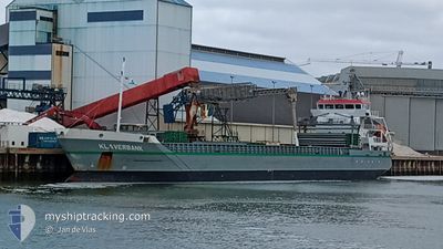
KLAVERBANK
General Cargo
Current Trip
| Time Travelled | 2 days |
|---|---|
| Remaining Time | --- |
| Distance Travelled | 457.61 nm |
| Remaining Distance | --- |
| AVG Speed | 8.1 Knots |
| MAX Speed | 13.5 Knots |
| AVG Wind | 8.1 knots |
| MAX Wind | 24 knots |
| MIN Temp | 9.3°C / 48.74°F |
| MAX Temp | 17°C / 62.6°F |
| Draught | 6.2 m |
| Position Received | 6 h, 40 m ago |
Current Position
| Longitude | 0.43271° |
|---|---|
| Latitude | 53.58874° |
| Status | At anchor |
| Speed | 0.2 Knots |
| Course | 332° |
| Area | North Sea |
| Station | T-AIS |
| Position Received | 6 h, 40 m ago |
Info
Information
The current position of KLAVERBANK is in North Sea with coordinates 53.58874° / 0.43271° as reported on 2024-05-31 21:49 by AIS to our vessel tracker app. The vessel's current speed is 0.2 Knots
The vessel KLAVERBANK (IMO: 9518244, MMSI: 246134000) is a General Cargo that was built in 2011 ( 13 years old ). It's sailing under the flag of [NL] Netherlands.
In this page you can find informations about the vessels current position, last detected port calls, and current voyage information. If the vessels is not in coverage by AIS you will find the latest position.
The current position of KLAVERBANK is detected by our AIS receivers and we are not responsible for the reliability of the data. The last position was recorded while the vessel was in Coverage by the Ais receivers of our vessel tracking app.
The current draught of KLAVERBANK as reported by AIS is 6.2 meters
Weather
| Temperature | 11.1°C / 51.98°F |
|---|---|
| Wind Speed | 20 knots |
| Direction | 348° NNW |
| Pressure | 1023 hPa |
| Humidity | 92.1 % |
| Cloud Coverage | 1 % |
Featured Company
Last Port Calls
| Port | Arrival | Departure | Time In Port |
|---|---|---|---|
| 2024-05-25 06:17 | 2024-05-29 11:44 | 4 d | |
| 2024-05-20 02:32 | 2024-05-23 17:14 | 3 d | |
| 2024-05-11 09:35 | 2024-05-13 20:17 | 2 d | |
| 2024-05-09 05:34 | 2024-05-10 08:34 | 1 d | |
| 2024-05-05 14:20 | 2024-05-07 16:06 | 2 d | |
| 2024-04-23 11:23 | 2024-04-27 12:26 | 4 d | |
| 2024-04-22 04:52 | 2024-04-23 03:10 | 22 h | |
| 2024-04-14 14:47 | 2024-04-14 17:18 | 2 h | |
| 2024-04-08 04:48 | 2024-04-10 00:43 | 1 d | |
| 2024-04-01 19:34 |
Last Trips
| Origin | Departure | Destination | Arrival | Distance | |
|---|---|---|---|---|---|
| 2024-05-23 19:14 | 2024-05-25 08:17 | 338.68 nm | |||
| 2024-05-13 21:17 | 2024-05-20 04:32 | 1434.47 nm | |||
| 2024-05-10 09:34 | 2024-05-11 10:35 | 209.59 nm | |||
| 2024-05-07 18:06 | 2024-05-09 06:34 | 302.23 nm | |||
| 2024-04-27 14:26 | 2024-05-05 16:20 | 1833.57 nm | |||
| 2024-04-23 05:10 | 2024-04-23 13:23 | 81.40 nm | |||
| 2024-04-14 19:18 | 2024-04-22 06:52 | 1714.00 nm | |||
| 2024-04-10 02:43 | 2024-04-14 16:47 | 1043.20 nm | |||
| 2024-04-01 20:34 | 2024-04-08 06:48 | 729.69 nm |
Events
| Time | Event | Details | Position / Dest | Info |
|---|---|---|---|---|
| 2024-05-31 21:52 | Status Changed | Default At anchor |
53.58866 / .43213
GBHUL
|
Speed: 0.2 kn Course: 332° |
| 2024-05-31 21:49 | Status Changed | At anchor Default |
53.58874 / .43271
GBHUL
|
Speed: 0.9 kn Course: 337° |
| 2024-05-31 21:49 | IN Coverage |
53.58874 / .43271
North Sea
GBHUL
|
Speed: 0.2 kn Course: 268.5° |
|
| 2024-05-31 21:49 | OUT of Coverage |
53.58874 / .43271
North Sea
GBHUL
|
Speed: 0.2 kn Course: 268.5° |
|
| 2024-05-31 21:18 | STOP Moving | 17.92 nm, East of GRIMSBY |
53.58938 / .43262
GBHUL
|
Speed: 0.2 kn Course: 351° |
| 2024-05-31 18:55 | Status Changed | Default Under way using engine |
53.60450 / .88018
GBHUL
|
Speed: 8.8 kn Course: 260.2° |
| 2024-05-31 18:55 | Status Changed | Under way using engine Default |
53.60482 / .88296
GBHUL
|
Speed: 8.9 kn Course: 262° |
| 2024-05-31 18:55 | IN Coverage |
53.60482 / .88296
North Sea
GBHUL
|
Speed: 8.8 kn Course: 260.2° |
|
| 2024-05-31 18:55 | OUT of Coverage |
53.60482 / .88296
North Sea
GBHUL
|
Speed: 8.8 kn Course: 260.2° |
|
| 2024-05-31 16:55 | OUT of Coverage |
53.67429 / 1.36545
North Sea
GBHUL
|
Speed: 9.1 kn Course: 253.9° |