
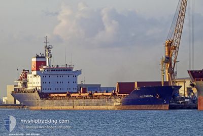
KLC ERCIYES
Bulk Carrier
Current Trip
| Time Travelled | 6 days |
|---|---|
| Remaining Time | 5 h, 21 mins |
| Distance Travelled | 1429.66 nm |
| Remaining Distance | 386.87 nm |
| AVG Speed | 11.1 Knots |
| MAX Speed | 12.7 Knots |
| AVG Wind | 8.2 knots |
| MAX Wind | 20.6 knots |
| MIN Temp | 13.1°C / 55.58°F |
| MAX Temp | 21.2°C / 70.16°F |
| Draught | 7 m |
| Position Received | 1 m ago |
Current Position
| Longitude | 28.92982° |
|---|---|
| Latitude | 40.97465° |
| Status | At anchor |
| Speed | 0.1 Knots |
| Course | 217° |
| Area | Sea of Marmara |
| Station | T-AIS |
| Position Received | 1 m ago |
Info
Information
The current position of KLC ERCIYES is in Sea of Marmara with coordinates 40.97465° / 28.92982° as reported on 2024-05-18 10:11 by AIS to our vessel tracker app. The vessel's current speed is 0.1 Knots and is heading at the port of SAMSUN. The estimated time of arrival as calculated by vessel tracking app is 2024-05-18 15:33 LT
The vessel KLC ERCIYES (IMO: 9132480, MMSI: 314687000) is a Bulk Carrier that was built in 1997 ( 27 years old ). It's sailing under the flag of [BB] Barbados.
In this page you can find informations about the vessels current position, last detected port calls, and current voyage information. If the vessels is not in coverage by AIS you will find the latest position.
The current position of KLC ERCIYES is detected by our AIS receivers and we are not responsible for the reliability of the data. The last position was recorded while the vessel was in Coverage by the Ais receivers of our vessel tracking app.
The current draught of KLC ERCIYES as reported by AIS is 7 meters
Weather
| Temperature | 20.2°C / 68.36°F |
|---|---|
| Wind Speed | 2 knots |
| Direction | 306° NW |
| Pressure | 1018 hPa |
| Humidity | 51 % |
| Cloud Coverage | 2 % |
Featured Company
Last Port Calls
| Port | Arrival | Departure | Time In Port |
|---|---|---|---|
| 2024-05-02 17:19 | 2024-05-11 13:47 | 8 d | |
| 2024-04-26 13:24 | 2024-04-26 21:32 | 8 h | |
| 2024-04-20 12:36 | 2024-04-26 12:52 | 6 d | |
| 2024-04-19 22:40 | 2024-04-20 11:52 | 13 h |
Last Trips
| Origin | Departure | Destination | Arrival | Distance | |
|---|---|---|---|---|---|
| 2024-04-26 22:32 | 2024-05-02 19:19 | 521.56 nm | |||
| 2024-04-26 13:52 | 2024-04-26 14:24 | 5.34 nm | |||
| 2024-04-20 12:52 | 2024-04-20 13:36 | 5.11 nm | |||
| 2024-02-20 17:58 | 2024-04-19 23:40 | 1680.42 nm |
Events
| Time | Event | Details | Position / Dest | Info |
|---|---|---|---|---|
| 2024-05-17 23:14 | Status Changed | At anchor Default |
40.97286 / 28.92783
TRSSX
|
Speed: Course: 53° |
| 2024-05-17 23:11 | Status Changed | Default At anchor |
40.97286 / 28.92774
TRSSX
|
Speed: Course: 52° |
| 2024-05-17 15:13 | Status Changed | At anchor Default |
40.97328 / 28.92740
TRSSX
|
Speed: Course: 70° |
| 2024-05-17 15:10 | Status Changed | Default At anchor |
40.97332 / 28.92739
TRSSX
|
Speed: Course: 71° |
| 2024-05-17 13:37 | Status Changed | At anchor Default |
40.97324 / 28.92760
TRSSX
|
Speed: Course: 66° |
| 2024-05-17 13:35 | Status Changed | Default At anchor |
40.97320 / 28.92758
TRSSX
|
Speed: Course: 66° |
| 2024-05-16 22:53 | Status Changed | At anchor Under way using engine |
40.97300 / 28.92952
TRSSX
|
Speed: 0.5 kn Course: 357° |
| 2024-05-16 22:51 | STOP Moving | 1.7 nm, East of ZEYTINBURNU |
40.97328 / 28.92958
TRSSX
|
Speed: 0.1 kn Course: 2° |
| 2024-05-16 13:46 | Status Changed | Under way using engine Default |
40.53556 / 27.08102
TRSSX
|
Speed: 11.3 kn Course: 67° |
| 2024-05-16 13:36 | IN Coverage |
40.53556 / 27.08102
Sea of Marmara
TRSSX
|
Speed: 11.4 kn Course: 65.9° |