
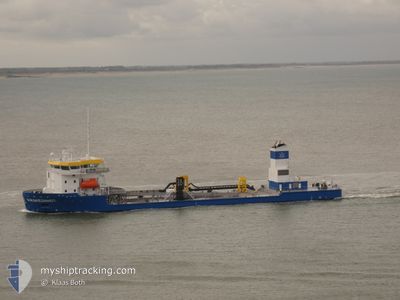
KRAKESANDT
Dredging or underwater ops
Current Trip
NL STEENBANK
| Time Travelled | 16 days |
|---|---|
| Remaining Time | --- |
| Distance Travelled | 870.29 nm |
| Remaining Distance | --- |
| AVG Speed | 9.4 Knots |
| MAX Speed | 14.6 Knots |
| AVG Wind | 12.3 knots |
| MAX Wind | 24.7 knots |
| MIN Temp | 10.4°C / 50.72°F |
| MAX Temp | 20.3°C / 68.54°F |
| Draught | 3.4 m |
| Position Received | Now |
Current Position
| Longitude | 3.34855° |
|---|---|
| Latitude | 51.65445° |
| Status | Restricted manoeuverability |
| Speed | 1.5 Knots |
| Course | 40° |
| Area | North Sea |
| Station | T-AIS |
| Position Received | Now |
Info
Information
The current position of KRAKESANDT is in North Sea with coordinates 51.65445° / 3.34855° as reported on 2024-06-09 08:36 by AIS to our vessel tracker app. The vessel's current speed is 1.5 Knots
The vessel KRAKESANDT (IMO: 9823807, MMSI: 244849000) is a Dredging or underwater ops It's sailing under the flag of [NL] Netherlands.
In this page you can find informations about the vessels current position, last detected port calls, and current voyage information. If the vessels is not in coverage by AIS you will find the latest position.
The current position of KRAKESANDT is detected by our AIS receivers and we are not responsible for the reliability of the data. The last position was recorded while the vessel was in Coverage by the Ais receivers of our vessel tracking app.
The current draught of KRAKESANDT as reported by AIS is 3.4 meters
Weather
| Temperature | 12.5°C / 54.5°F |
|---|---|
| Wind Speed | 13 knots |
| Direction | 286° WNW |
| Pressure | 1012 hPa |
| Humidity | 69.6 % |
| Cloud Coverage | 60 % |
Featured Company
Last Port Calls
| Port | Arrival | Departure | Time In Port |
|---|---|---|---|
| 2024-05-23 08:52 | 2024-05-24 04:34 | 19 h | |
| 2024-04-25 05:17 | 2024-04-25 09:29 | 4 h | |
| 2024-04-02 05:07 |
Most Visited Ports (Last year)
| Port | Arrivals | |
|---|---|---|
| 9 | ||
| 3 | ||
| 2 |
Last Trips
| Origin | Departure | Destination | Arrival | Distance | |
|---|---|---|---|---|---|
| 2024-04-25 11:29 | 2024-05-23 10:52 | 1676.60 nm | |||
| 2024-04-02 07:07 | 2024-04-25 07:17 | 1488.79 nm |
Events
| Time | Event | Details | Position / Dest | Info |
|---|---|---|---|---|
| 2024-06-09 07:23 | Status Changed | Restricted manoeuverability Under way using engine |
51.63940 / 3.33413
NL STEENBANK
|
Speed: 10.3 kn Course: 308.3° |
| 2024-06-09 05:01 | START Moving | 1.18 nm, West of ELLEWOUTSDIJK |
51.39056 / 3.78733
NL STEENBANK
|
Speed: 4.5 kn Course: 225° |
| 2024-06-09 04:56 | Status Changed | Under way using engine At anchor |
51.39195 / 3.78892
NL STEENBANK
|
Speed: Course: 137° |
| 2024-06-09 04:54 | Status Changed | At anchor Default |
51.39194 / 3.78892
NL STEENBANK
|
Speed: Course: -1° |
| 2024-06-09 04:52 | Status Changed | Default At anchor |
51.39167 / 3.78833
NL STEENBANK
|
Speed: Course: 137° |
| 2024-06-09 03:44 | Destination Changed | NL STEENBANK MSB |
51.39225 / 3.78853
NL STEENBANK
|
Speed: Course: 306° |
| 2024-06-08 16:03 | Destination Changed | MSB EVERINGEN |
51.39212 / 3.78844
MSB
|
Speed: 0.1 kn Course: 260° |
| 2024-06-08 16:03 | ETA Changed | 2024/06/09 10:30 2024/06/08 12:30 |
51.39212 / 3.78844
MSB
|
Speed: 0.1 kn Course: 260° |
| 2024-06-08 10:33 | Status Changed | At anchor Under way using engine |
51.39222 / 3.78846
EVERINGEN
|
Speed: Course: 287° |
| 2024-06-08 10:32 | STOP Moving | 1.17 nm, West of ELLEWOUTSDIJK |
51.39223 / 3.78849
EVERINGEN
|
Speed: 0.3 kn Course: 285° |