
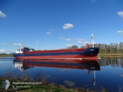
KREETE
General Cargo
Current Trip
| Time Travelled | 1 day |
|---|---|
| Remaining Time | --- |
| Distance Travelled | 304.01 nm |
| Remaining Distance | --- |
| AVG Speed | 7.5 Knots |
| MAX Speed | 13 Knots |
| AVG Wind | 9.5 knots |
| MAX Wind | 16.3 knots |
| MIN Temp | 12°C / 53.6°F |
| MAX Temp | 19.3°C / 66.74°F |
| Draught | 5.2 m |
| Position Received | 8 h, 53 m ago |
Current Position
| Longitude | 4.71449° |
|---|---|
| Latitude | 53.48734° |
| Status | Under way using engine |
| Speed | 10.7 Knots |
| Course | 251.5° |
| Area | North Sea |
| Station | T-AIS |
| Position Received | 8 h, 53 m ago |
Info
Information
The current position of KREETE is in North Sea with coordinates 53.48734° / 4.71449° as reported on 2024-05-20 13:15 by AIS to our vessel tracker app. The vessel's current speed is 10.7 Knots and is heading at the port of KINGS LYNN. The estimated time of arrival as calculated by vessel tracking app is 2024-05-21 09:00 LT
The vessel KREETE (IMO: 9279408, MMSI: 305967000) is a General Cargo that was built in 2003 ( 21 years old ). It's sailing under the flag of [AG] Antigua Barbuda.
In this page you can find informations about the vessels current position, last detected port calls, and current voyage information. If the vessels is not in coverage by AIS you will find the latest position.
The current position of KREETE is detected by our AIS receivers and we are not responsible for the reliability of the data. The last position was recorded while the vessel was in Coverage by the Ais receivers of our vessel tracking app.
The current draught of KREETE as reported by AIS is 5.2 meters
Weather
| Temperature | 12.2°C / 53.96°F |
|---|---|
| Wind Speed | 15 knots |
| Direction | 28° NNE |
| Pressure | 1011 hPa |
| Humidity | 92.5 % |
| Cloud Coverage | 69 % |
Featured Company
Last Port Calls
| Port | Arrival | Departure | Time In Port |
|---|---|---|---|
| 2024-05-19 11:51 | 2024-05-19 12:31 | 39 m | |
| 2024-05-17 06:16 | 2024-05-17 20:04 | 13 h | |
| 2024-05-14 04:27 | 2024-05-14 21:19 | 16 h | |
| 2024-05-09 20:35 | 2024-05-11 18:40 | 1 d | |
| 2024-05-07 12:08 | 2024-05-08 17:36 | 1 d | |
| 2024-05-03 00:15 | 2024-05-06 14:35 | 3 d | |
| 2024-04-30 19:20 | 2024-05-02 18:12 | 1 d | |
| 2024-04-29 08:12 | 2024-04-30 13:49 | 1 d | |
| 2024-04-27 08:28 | 2024-04-27 23:41 | 15 h | |
| 2024-04-26 07:28 | 2024-04-26 16:01 | 8 h |
Last Trips
| Origin | Departure | Destination | Arrival | Distance | |
|---|---|---|---|---|---|
| 2024-05-17 23:04 | 2024-05-19 13:51 | 410.81 nm | |||
| 2024-05-15 00:19 | 2024-05-17 09:16 | 340.64 nm | |||
| 2024-05-11 20:40 | 2024-05-14 07:27 | 604.36 nm | |||
| 2024-05-08 19:36 | 2024-05-09 22:35 | 280.85 nm | |||
| 2024-05-06 16:35 | 2024-05-07 14:08 | 216.11 nm | |||
| 2024-05-02 20:12 | 2024-05-03 02:15 | 58.15 nm | |||
| 2024-04-30 15:49 | 2024-04-30 21:20 | 55.74 nm | |||
| 2024-04-28 02:41 | 2024-04-29 10:12 | 348.56 nm | |||
| 2024-04-26 18:01 | 2024-04-27 11:28 | 174.92 nm | |||
| 2024-04-25 14:34 | 2024-04-26 09:28 | 186.52 nm |
Events
| Time | Event | Details | Position / Dest | Info |
|---|---|---|---|---|
| 2024-05-20 13:17 | Status Changed | Default Under way using engine |
53.48500 / 4.70333
GBKLN
|
Speed: 10.7 kn Course: 251.5° |
| 2024-05-20 13:15 | OUT of Coverage |
53.48734 / 4.71449
North Sea
GBKLN
|
Speed: 10.7 kn Course: 251.5° |
|
| 2024-05-20 09:21 | Detected in Sea | Dutch part of the North Sea |
53.72324 / 5.85952
North Sea
GBKLN
|
Speed: 10.2 kn Course: 251.2° |
| 2024-05-20 09:21 | Status Changed | Under way using engine Default |
53.72324 / 5.85952
GBKLN
|
Speed: 10.2 kn Course: 251° |
| 2024-05-20 09:08 | IN Coverage |
53.72324 / 5.85952
North Sea
GBKLN
|
Speed: 10.2 kn Course: 251.2° |
|
| 2024-05-20 05:29 | Status Changed | Default Under way using engine |
53.89310 / 6.80955
GBKLN
|
Speed: 8.6 kn Course: 259° |
| 2024-05-20 05:23 | OUT of Coverage |
53.89623 / 6.83104
North Sea
GBKLN
|
Speed: 8.6 kn Course: 259° |
|
| 2024-05-20 02:36 | Status Changed | Under way using engine Default |
54.00257 / 7.57407
GBKLN
|
Speed: 10 kn Course: 255° |
| 2024-05-20 02:25 | Status Changed | Default Under way using engine |
54.01102 / 7.62891
GBKLN
|
Speed: 10.6 kn Course: 254.7° |
| 2024-05-19 20:47 | START Moving | 0.87 nm, South West of BRUNSBUETTEL |
53.89091 / 9.14632
GBKLN
|
Speed: 3.6 kn Course: 222° |