
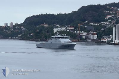
KV JAN MAYEN
Law Enforcement
Current Trip
COASTGUARD OPERATION
| Time Travelled | 4 days |
|---|---|
| Remaining Time | --- |
| Distance Travelled | 311.57 nm |
| Remaining Distance | --- |
| AVG Speed | 9.4 Knots |
| MAX Speed | 15.1 Knots |
| AVG Wind | 6.2 knots |
| MAX Wind | 19 knots |
| MIN Temp | 7.8°C / 46.04°F |
| MAX Temp | 13.7°C / 56.66°F |
| Draught | 6.2 m |
| Position Received | 1 m ago |
Current Position
| Longitude | 5.21923° |
|---|---|
| Latitude | 60.33389° |
| Status | Moored |
| Speed | |
| Course | 179° |
| Area | North Sea |
| Station | T-AIS |
| Position Received | 1 m ago |
Info
Information
The current position of KV JAN MAYEN is in North Sea with coordinates 60.33389° / 5.21923° as reported on 2024-06-18 14:12 by AIS to our vessel tracker app. The vessel's current speed is 0 Knots
The vessel KV JAN MAYEN (IMO: 9911575, MMSI: 257984000) is a Law Enforcement It's sailing under the flag of [NO] Norway.
In this page you can find informations about the vessels current position, last detected port calls, and current voyage information. If the vessels is not in coverage by AIS you will find the latest position.
The current position of KV JAN MAYEN is detected by our AIS receivers and we are not responsible for the reliability of the data. The last position was recorded while the vessel was in Coverage by the Ais receivers of our vessel tracking app.
The current draught of KV JAN MAYEN as reported by AIS is 6.2 meters
Weather
| Temperature | 12.9°C / 55.22°F |
|---|---|
| Wind Speed | 5 knots |
| Direction | 214° SW |
| Pressure | 1009.1 hPa |
| Humidity | 76.1 % |
| Cloud Coverage | 41 % |
Featured Company
Last Port Calls
| Port | Arrival | Departure | Time In Port |
|---|---|---|---|
| 2024-06-11 17:35 | 2024-06-13 17:21 | 1 d | |
| 2024-06-11 05:54 | 2024-06-11 11:26 | 5 h | |
| 2024-06-08 09:40 | 2024-06-08 10:11 | 30 m | |
| 2024-06-06 16:26 | 2024-06-08 08:49 | 1 d | |
| 2024-06-03 10:10 | 2024-06-06 15:59 | 3 d | |
| 2024-06-03 08:27 | 2024-06-03 09:02 | 34 m | |
| 2024-05-25 05:54 | 2024-05-25 11:41 | 5 h | |
| 2024-05-19 12:04 | 2024-05-19 15:31 | 3 h | |
| 2024-05-06 16:34 | 2024-05-08 14:23 | 1 d | |
| 2024-04-30 12:11 | 2024-04-30 17:09 | 4 h |
Last Trips
| Origin | Departure | Destination | Arrival | Distance | |
|---|---|---|---|---|---|
| 2024-06-11 13:26 | 2024-06-11 19:35 | 61.70 nm | |||
| 2024-06-08 12:11 | 2024-06-11 07:54 | 962.76 nm | |||
| 2024-06-08 10:49 | 2024-06-08 11:40 | 3.21 nm | |||
| 2024-06-06 17:59 | 2024-06-06 18:26 | 1.53 nm | |||
| 2024-06-03 11:02 | 2024-06-03 12:10 | 6.25 nm | |||
| 2024-05-25 13:41 | 2024-06-03 10:27 | 1168.92 nm | |||
| 2024-05-19 17:31 | 2024-05-25 07:54 | 890.97 nm | |||
| 2024-05-08 16:23 | 2024-05-19 14:04 | 1606.25 nm | |||
| 2024-04-30 19:09 | 2024-05-06 18:34 | 1117.84 nm | |||
| 2024-04-30 11:23 | 2024-04-30 14:11 | 36.05 nm |
Events
| Time | Event | Details | Position / Dest | Info |
|---|---|---|---|---|
| 2024-06-16 17:32 | Status Changed | Moored Under way using engine |
60.33394 / 5.21930
COASTGUARD OPERATION
|
Speed: Course: 179° |
| 2024-06-16 16:55 | STOP Moving | 2.91 nm, South East of KNARREVIK |
60.33236 / 5.21998
COASTGUARD OPERATION
|
Speed: 0.2 kn Course: 125° |
| 2024-06-16 12:07 | Change Sea Area | Norwegian part of the North Sea Norwegian part of the Norwegian Sea |
60.99658 / 4.40276
North Sea
|
Speed: 10.4 kn Course: 129.8° |
| 2024-06-16 09:40 | START Moving | 3.35 nm, North of LUTELANDET |
61.29965 / 4.96905
COASTGUARD OPERATION
|
Speed: 4.6 kn Course: 230° |
| 2024-06-16 09:04 | STOP Moving | 3.37 nm, North of LUTELANDET |
61.30014 / 4.97410
COASTGUARD OPERATION
|
Speed: 0.3 kn Course: 284° |
| 2024-06-16 08:52 | START Moving | 3.35 nm, North of LUTELANDET |
61.29986 / 4.98073
COASTGUARD OPERATION
|
Speed: 4.3 kn Course: 278° |
| 2024-06-15 23:04 | STOP Moving | 2.88 nm, North of LUTELANDET |
61.29083 / 4.99925
COASTGUARD OPERATION
|
Speed: 0.2 kn Course: 309° |
| 2024-06-15 22:56 | START Moving | 3.28 nm, North of LUTELANDET |
61.29724 / 5.00340
COASTGUARD OPERATION
|
Speed: 3.7 kn Course: 228° |
| 2024-06-15 22:02 | STOP Moving | 3.44 nm, North of LUTELANDET |
61.29879 / 5.01204
COASTGUARD OPERATION
|
Speed: 0.3 kn Course: 301° |
| 2024-06-15 17:32 | START Moving | 6.06 nm, North of LUTELANDET |
61.34027 / 5.04038
COASTGUARD OPERATION
|
Speed: 8 kn Course: 153° |