
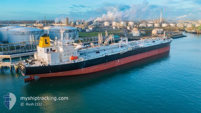
LADY HENRIETTA
Oil Products Tanker
Current Trip
FOR ORDERS
| Time Travelled | 18 days |
|---|---|
| Remaining Time | --- |
| Distance Travelled | 4522.53 nm |
| Remaining Distance | --- |
| AVG Speed | 11.4 Knots |
| MAX Speed | 16.5 Knots |
| AVG Wind | 12.4 knots |
| MAX Wind | 28.4 knots |
| MIN Temp | 9.3°C / 48.74°F |
| MAX Temp | 27.3°C / 81.14°F |
| Draught | 8.4 m |
| Position Received | 3 m ago |
Current Position
| Longitude | -8.05328° |
|---|---|
| Latitude | 34.52833° |
| Status | Under way using engine |
| Speed | 12.1 Knots |
| Course | 224.4° |
| Area | North Atlantic Ocean |
| Station | T-AIS |
| Position Received | 3 m ago |
Info
Information
The current position of LADY HENRIETTA is in North Atlantic Ocean with coordinates 34.52833° / -8.05328° as reported on 2024-06-25 07:18 by AIS to our vessel tracker app. The vessel's current speed is 12.1 Knots
The vessel LADY HENRIETTA (IMO: 9604380, MMSI: 538010003) is a Oil Products Tanker that was built in 2012 ( 12 years old ). It's sailing under the flag of [MH] Marshall Is.
In this page you can find informations about the vessels current position, last detected port calls, and current voyage information. If the vessels is not in coverage by AIS you will find the latest position.
The current position of LADY HENRIETTA is detected by our AIS receivers and we are not responsible for the reliability of the data. The last position was recorded while the vessel was in Coverage by the Ais receivers of our vessel tracking app.
The current draught of LADY HENRIETTA as reported by AIS is 8.4 meters
Weather
| Temperature | 20.6°C / 69.08°F |
|---|---|
| Wind Speed | 13 knots |
| Direction | 334° NNW |
| Pressure | 1010.8 hPa |
| Humidity | 88.7 % |
| Cloud Coverage | 39 % |
Featured Company
Most Visited Ports (Last year)
| Port | Arrivals | |
|---|---|---|
| 3 | ||
| 2 | ||
| 1 | ||
| 1 | ||
| 1 | ||
| 1 |
Events
| Time | Event | Details | Position / Dest | Info |
|---|---|---|---|---|
| 2024-06-25 07:18 | Status Changed | Under way using engine Default |
34.52833 / -8.05328
FOR ORDERS
|
Speed: 12 kn Course: 228° |
| 2024-06-25 07:18 | IN Coverage |
34.52833 / -8.05328
North Atlantic Ocean
FOR ORDERS
|
Speed: 12.1 kn Course: 224.4° |
|
| 2024-06-25 06:12 | Status Changed | Default Under way using engine |
34.68204 / -7.86128
FOR ORDERS
|
Speed: 12 kn Course: 227.4° |
| 2024-06-25 05:40 | Status Changed | Under way using engine Default |
34.75683 / -7.76596
FOR ORDERS
|
Speed: 12.1 kn Course: 227° |
| 2024-06-25 05:40 | OUT of Coverage |
34.75683 / -7.76596
North Atlantic Ocean
FOR ORDERS
|
Speed: 12 kn Course: 227.4° |
|
| 2024-06-25 05:18 | Status Changed | Default Under way using engine |
34.80638 / -7.70442
FOR ORDERS
|
Speed: 12.1 kn Course: 227.6° |
| 2024-06-25 04:18 | Status Changed | Under way using engine Default |
34.94607 / -7.52737
FOR ORDERS
|
Speed: 12.1 kn Course: 228° |
| 2024-06-25 03:55 | Status Changed | Default Under way using engine |
34.99951 / -7.45767
FOR ORDERS
|
Speed: 12.5 kn Course: 225.7° |
| 2024-06-25 03:18 | Status Changed | Under way using engine Default |
35.08784 / -7.34555
FOR ORDERS
|
Speed: 12.5 kn Course: 228° |
| 2024-06-25 02:42 | Status Changed | Default Under way using engine |
35.17516 / -7.23078
FOR ORDERS
|
Speed: 12.4 kn Course: 225.1° |