
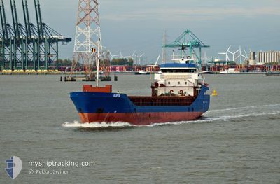
LAFJELL
General Cargo
Aktuelle Reise
| Trip Time | 23 h, 42 Minuten |
|---|---|
| Trip Distanz | 178.06 nm |
| Durchschnittliche Geschwindigkeit | 8.2 Knoten |
| Maximale Geschwindigkeit | 12 Knoten |
| Tiefgang | 6.6 m |
| Durchschnittliche Windgeschwindigkeit | 13 Knoten |
| Maximale Windgeschwindigkeit | 24 Knoten |
| Minimale Temperatur | 8.9°C / 48.02°F |
| Maximale Temperatur | 13.6°C / 56.48°F |
| Position erhalten | Jetzt |
Aktuelle Position
| Länge | --- |
|---|---|
| Breite | --- |
| Zustand | Moored |
| Geschwindigkeit | |
| Kurs | 261° |
| Gebiet | Kattegat |
| Station | T-AIS |
| Position erhalten | Jetzt |
Schiffsdetails
Information
Die LAFJELL befindet sich derzeit in Kattegat mit den Koordinaten 55.55751° / 9.74204°, Diese Position wurde am 2024-10-31 22:56 von unserer Schiffsverfolgungs-App über AIS erfasst. Das Schiff fährt momentan mit einer Geschwindigkeit von 0 Knoten und liegt im Hafen von FREDERICIA .
Das Schiff LAFJELL (IMO: 9213997, MMSI: 257708000) ist General Cargo das wurde im Jahr 2001 ( 23 Jahre alt ) gebaut. und fährt unter der Flagge von [NO] Norway.
Auf dieser Seite erhalten Sie Informationen zur aktuellen Position des Schiffes, zu den letzten bekannten Hafenanläufen und zu den aktuellen Reiseinformationen. Sollte das Schiff nicht durch AIS abgedeckt sein, wird die zuletzt erfasste Position angezeigt.
Die LAFJELL wird durch unsere AIS-Empfänger ermittelt. Wir übernehmen keine Gewähr für die Richtigkeit der Daten. Die letzte Position wurde von unseren AIS-Empfängern aufgezeichnet, während das Schiff in Reichweite war.
Der aktuelle Entwurf von LAFJELL, wie von AIS gemeldet, betragt 6.6 meter
Wetter
| Temperatur | 12.3°C / 54.14°F |
|---|---|
| Windgeschwindigkeit | 21 Knoten |
| Windrichtung | 264° W |
| Luftdruck | 1016.7 hPa |
| Luftfeuchtigkeit | 82.2 % |
| Wolken | 100 % |
Featured Company
Letzte Hafenanläufe
| Hafen | Ankunft | Abfahrt | Time In Port |
|---|---|---|---|
| 2024-10-31 18:52 | |||
| 2024-10-27 06:48 | 2024-10-30 19:10 | 3 d | |
| 2024-10-25 09:59 | 2024-10-26 16:57 | 1 d | |
| 2024-10-21 16:56 | 2024-10-23 18:42 | 2 d | |
| 2024-10-13 18:34 | 2024-10-18 17:38 | 4 d | |
| 2024-10-09 21:46 | 2024-10-10 17:31 | 19 h | |
| 2024-10-07 13:08 | 2024-10-09 13:30 | 2 d | |
| 2024-10-03 00:46 | 2024-10-04 16:17 | 1 d | |
| 2024-10-01 19:08 | 2024-10-02 23:13 | 1 d | |
| 2024-09-25 20:32 | 2024-09-27 17:10 | 1 d |
Letzte Reisen
| Herkunft | Abfahrt | Ziel | Ankunft | Distanz | |
|---|---|---|---|---|---|
| 2024-10-30 20:10 | 2024-10-31 19:52 | 178.06 nm | |||
| 2024-10-26 18:57 | 2024-10-27 07:48 | 153.15 nm | |||
| 2024-10-23 19:42 | 2024-10-25 11:59 | 395.46 nm | |||
| 2024-10-18 18:38 | 2024-10-21 17:56 | 192.89 nm | |||
| 2024-10-10 18:31 | 2024-10-13 19:34 | 698.16 nm | |||
| 2024-10-09 14:30 | 2024-10-09 22:46 | 88.83 nm | |||
| 2024-10-04 18:17 | 2024-10-07 14:08 | 657.39 nm | |||
| 2024-10-03 01:13 | 2024-10-03 02:46 | 15.91 nm | |||
| 2024-09-27 19:10 | 2024-10-01 21:08 | 713.22 nm | |||
| 2024-09-23 19:09 | 2024-09-25 22:32 | 412.71 nm |
Events
| Zeit | Ereignis | Details | Position / Ziel | Information |
|---|---|---|---|---|
| 2024-10-31 19:29 | geänderter Status | Moored Under way using engine |
55.55750 / 9.74200
[DK] FREDERICIA
|
Geschwindigkeit: Kurs: 262° |
| 2024-10-31 19:00 | STOP Bewegung |
55.55694 / 9.74219
[DK] FREDERICIA
|
Geschwindigkeit: 0.3 kn Kurs: 302° |
|
| 2024-10-31 18:52 | ZIELHAFEN |
|
55.55546 / 9.74529
[DK] FREDERICIA
|
Geschwindigkeit: 2 kn Kurs: 312° |
| 2024-10-31 12:40 | Ändere Seegebiet | Danish part of the Kattegat Danish part of the Baltic Sea |
54.81539 / 10.25458
Kattegat
DKFRC
|
Geschwindigkeit: 9.8 kn Kurs: 329.8° |
| 2024-10-31 11:19 | Ändere Seegebiet | Danish part of the Baltic Sea German part of the Baltic Sea |
54.61237 / 10.41379
Baltic Sea
DKFRC
|
Geschwindigkeit: 10.4 kn Kurs: 345.5° |
| 2024-10-31 10:09 | Ändere Seegebiet | German part of the Baltic Sea German part of the North Sea |
54.45975 / 10.26378
Baltic Sea
DKFRC
|
Geschwindigkeit: 10.4 kn Kurs: 35.1° |
| 2024-10-31 09:23 | START Bewegung | 1.37 nm, South West of STICKENHΟRN SPORT |
54.36529 / 10.14318
DKFRC
|
Geschwindigkeit: 5.4 kn Kurs: 99.6° |
| 2024-10-31 09:13 | geänderte voraussichtliche Ankunftszeit | 2024/10/31 18:00 2024/10/31 16:00 |
54.36565 / 10.14009
DKFRC
|
Geschwindigkeit: Kurs: 103° |
| 2024-10-31 08:54 | STOP Bewegung | 1.42 nm, South West of STICKENHΟRN SPORT |
54.36565 / 10.14005
DKFRC
|
Geschwindigkeit: 0.2 kn Kurs: 103° |
| 2024-10-31 03:01 | geänderter Status | Under way using engine Default |
54.09693 / 9.32834
DKFRC
|
Geschwindigkeit: 6.8 kn Kurs: 18° |