
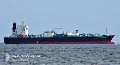
LEO SUNRISE
Tanker
Current Trip
| Time Travelled | 8 days |
|---|---|
| Remaining Time | --- |
| Distance Travelled | 3017.46 nm |
| Remaining Distance | --- |
| AVG Speed | 14.3 Knots |
| MAX Speed | 16.5 Knots |
| AVG Wind | 8.9 knots |
| MAX Wind | 22.3 knots |
| MIN Temp | 23.9°C / 75.02°F |
| MAX Temp | 30.5°C / 86.9°F |
| Draught | 10.5 m |
| Position Received | 8 d ago |
Current Position
| Longitude | 117.61226° |
|---|---|
| Latitude | -18.91722° |
| Status | Under way using engine |
| Speed | 14.7 Knots |
| Course | 28.4° |
| Area | Indian Ocean |
| Station | T-AIS |
| Position Received | 8 d ago |
Info
Information
The current position of LEO SUNRISE is in Indian Ocean with coordinates -18.91722° / 117.61226° as reported on 2024-06-18 07:06 by AIS to our vessel tracker app. The vessel's current speed is 14.7 Knots and is heading at the port of ONSAN. The estimated time of arrival as calculated by vessel tracking app is 2024-06-28 21:00 LT
The vessel LEO SUNRISE (IMO: 9678525, MMSI: 565099000) is a Tanker It's sailing under the flag of [SG] Singapore.
In this page you can find informations about the vessels current position, last detected port calls, and current voyage information. If the vessels is not in coverage by AIS you will find the latest position.
The current position of LEO SUNRISE is detected by our AIS receivers and we are not responsible for the reliability of the data. The last position was recorded while the vessel was in Coverage by the Ais receivers of our vessel tracking app.
The current draught of LEO SUNRISE as reported by AIS is 10.5 meters
Weather
| Temperature | 28.9°C / 84.02°F |
|---|---|
| Wind Speed | 13 knots |
| Direction | 157° SSE |
| Pressure | 1015.8 hPa |
| Humidity | 78.6 % |
| Cloud Coverage | 92 % |
Featured Company
Last Port Calls
| Port | Arrival | Departure | Time In Port |
|---|---|---|---|
| 2024-06-16 08:46 | 2024-06-17 22:56 | 1 d | |
| 2024-06-11 05:36 | 2024-06-13 08:31 | 2 d | |
| 2024-06-06 21:59 | 2024-06-08 06:08 | 1 d | |
| 2024-05-28 15:47 | 2024-05-29 21:03 | 1 d | |
| 2024-05-18 11:43 | 2024-05-19 12:34 | 1 d | |
| 2024-05-13 23:01 | 2024-05-15 06:11 | 1 d | |
| 2024-05-06 05:15 | 2024-05-11 01:05 | 4 d | |
| 2024-05-02 01:12 | 2024-05-03 05:58 | 1 d | |
| 2024-04-23 01:28 | 2024-04-24 04:25 | 1 d | |
| 2024-04-07 23:16 | 2024-04-08 22:41 | 23 h |
Last Trips
| Origin | Departure | Destination | Arrival | Distance | |
|---|---|---|---|---|---|
| 2024-06-13 16:31 | 2024-06-16 16:46 | 931.34 nm | |||
| 2024-06-08 14:08 | 2024-06-11 13:36 | 938.16 nm | |||
| 2024-05-30 07:03 | 2024-06-07 05:59 | 2747.07 nm | |||
| 2024-05-19 19:34 | 2024-05-29 01:47 | 2898.35 nm | |||
| 2024-05-15 14:11 | 2024-05-18 18:43 | 1029.83 nm | |||
| 2024-05-11 09:05 | 2024-05-14 07:01 | 917.98 nm | |||
| 2024-05-03 13:58 | 2024-05-06 13:15 | 938.58 nm | |||
| 2024-04-24 14:25 | 2024-05-02 09:12 | 2749.74 nm | |||
| 2024-04-09 06:41 | 2024-04-23 11:28 | 3645.15 nm | |||
| 2024-04-02 07:47 | 2024-04-08 07:16 | 1749.09 nm |
Events
| Time | Event | Details | Position / Dest | Info |
|---|---|---|---|---|
| 2024-06-18 07:12 | Status Changed | Default Under way using engine |
-18.89534 / 117.62515
KR USN
|
Speed: 14.7 kn Course: 28.4° |
| 2024-06-18 07:06 | OUT of Coverage |
-18.91722 / 117.61226
Indian Ocean
KR USN
|
Speed: 14.7 kn Course: 28.4° |
|
| 2024-06-18 07:00 | IN Coverage |
-18.93117 / 117.60413
Indian Ocean
KR USN
|
Speed: 14.5 kn Course: 28.1° |
|
| 2024-06-18 06:59 | Status Changed | Under way using engine Default |
-18.94208 / 117.59771
KR USN
|
Speed: 14.5 kn Course: 29° |
| 2024-06-18 05:12 | Status Changed | Default Under way using engine |
-19.31070 / 117.36717
KR USN
|
Speed: 15.2 kn Course: 25.6° |
| 2024-06-18 05:07 | OUT of Coverage |
-19.33160 / 117.35561
Indian Ocean
KR USN
|
Speed: 15.2 kn Course: 25.6° |
|
| 2024-06-18 05:06 | Status Changed | Under way using engine Default |
-19.33434 / 117.35421
KR USN
|
Speed: 15.1 kn Course: 27° |
| 2024-06-18 04:52 | IN Coverage |
-19.33160 / 117.35561
Indian Ocean
KR USN
|
Speed: 15.2 kn Course: 25.6° |
|
| 2024-06-18 03:00 | Status Changed | Default Under way using engine |
-19.80423 / 117.08398
KR USN
|
Speed: 15 kn Course: 30.9° |
| 2024-06-18 02:54 | OUT of Coverage |
-19.82698 / 117.06917
Indian Ocean
KR USN
|
Speed: 15 kn Course: 30.9° |