
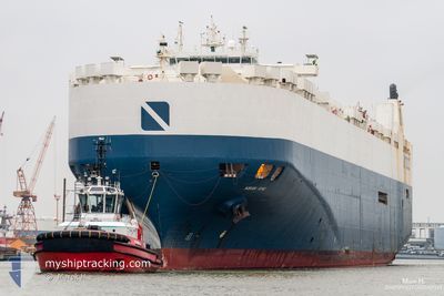
LIBERTY KING
Vehicles Carrier
Current Trip
| Time Travelled | 3 days |
|---|---|
| Remaining Time | --- |
| Distance Travelled | 413.93 nm |
| Remaining Distance | --- |
| AVG Speed | 14.8 Knots |
| MAX Speed | 21.6 Knots |
| AVG Wind | 7.7 knots |
| MAX Wind | 23.8 knots |
| MIN Temp | 7.4°C / 45.32°F |
| MAX Temp | 20.8°C / 69.44°F |
| Draught | 7.9 m |
| Position Received | 3 m ago |
Current Position
| Longitude | -122.49777° |
|---|---|
| Latitude | 47.30710° |
| Status | At anchor |
| Speed | 0.4 Knots |
| Course | 209° |
| Area | The Coastal Waters of Southeast Alaska and British Columbia |
| Station | T-AIS |
| Position Received | 3 m ago |
Info
Information
The current position of LIBERTY KING is in The Coastal Waters of Southeast Alaska and British Columbia with coordinates 47.30710° / -122.49777° as reported on 2024-05-28 23:02 by AIS to our vessel tracker app. The vessel's current speed is 0.4 Knots
The vessel LIBERTY KING (IMO: 9203291, MMSI: 538009492) is a Vehicles Carrier that was built in 1998 ( 26 years old ). It's sailing under the flag of [MH] Marshall Is.
In this page you can find informations about the vessels current position, last detected port calls, and current voyage information. If the vessels is not in coverage by AIS you will find the latest position.
The current position of LIBERTY KING is detected by our AIS receivers and we are not responsible for the reliability of the data. The last position was recorded while the vessel was in Coverage by the Ais receivers of our vessel tracking app.
The current draught of LIBERTY KING as reported by AIS is 7.9 meters
Weather
| Temperature | 11.7°C / 53.06°F |
|---|---|
| Wind Speed | 7 knots |
| Direction | 206° SSW |
| Pressure | 1020.4 hPa |
| Humidity | 84.5 % |
| Cloud Coverage | 100 % |
Featured Company
Last Port Calls
| Port | Arrival | Departure | Time In Port |
|---|---|---|---|
| 2024-05-24 11:05 | 2024-05-25 00:58 | 13 h | |
| 2024-05-11 21:34 | 2024-05-12 20:42 | 23 h | |
| 2024-05-10 02:04 | 2024-05-11 09:32 | 1 d | |
| 2024-04-23 13:28 | 2024-04-28 02:09 | 4 d | |
| 2024-04-20 19:31 | 2024-04-23 11:44 | 2 d | |
| 2024-04-18 19:11 | 2024-04-20 06:06 | 1 d | |
| 2024-03-27 23:07 | 2024-03-28 22:39 | 23 h | |
| 2024-03-26 22:04 | 2024-03-27 12:19 | 14 h | |
| 2024-03-24 06:01 | 2024-03-25 06:20 | 1 d | |
| 2024-03-09 20:57 | 2024-03-10 07:07 | 10 h |
Most Visited Ports (Last year)
| Port | Arrivals | |
|---|---|---|
| 7 | ||
| 5 | ||
| 4 | ||
| 4 | ||
| 3 | ||
| 2 |
Last Trips
| Origin | Departure | Destination | Arrival | Distance | |
|---|---|---|---|---|---|
| 2024-05-13 05:42 | 2024-05-24 04:05 | 4777.17 nm | |||
| 2024-05-11 18:32 | 2024-05-12 06:34 | 110.81 nm | |||
| 2024-04-27 19:09 | 2024-05-10 11:04 | 4710.54 nm | |||
| 2024-04-23 04:44 | 2024-04-23 06:28 | 23.55 nm | |||
| 2024-04-19 23:06 | 2024-04-20 12:31 | 162.30 nm | |||
| 2024-03-29 07:39 | 2024-04-18 12:11 | 4911.79 nm | |||
| 2024-03-27 21:19 | 2024-03-28 08:07 | 127.43 nm | |||
| 2024-03-25 15:20 | 2024-03-27 07:04 | 506.53 nm | |||
| 2024-03-09 23:07 | 2024-03-24 15:01 | 5098.91 nm | |||
| 2024-02-22 18:33 | 2024-03-09 12:57 | 452.37 nm |
Events
| Time | Event | Details | Position / Dest | Info |
|---|---|---|---|---|
| 2024-05-27 06:11 | Status Changed | At anchor Default |
47.30648 / -122.49780
US TIW
|
Speed: Course: -1° |
| 2024-05-27 06:06 | Status Changed | Default At anchor |
47.30500 / -122.49667
US TIW
|
Speed: Course: 166° |
| 2024-05-27 01:11 | Status Changed | At anchor Default |
47.30620 / -122.49847
US TIW
|
Speed: Course: -1° |
| 2024-05-27 01:06 | Status Changed | Default At anchor |
47.30500 / -122.49834
US TIW
|
Speed: 0.1 kn Course: 164° |
| 2024-05-26 04:56 | Status Changed | At anchor Under way using engine |
47.30534 / -122.49781
US TIW
|
Speed: 0.5 kn Course: 208° |
| 2024-05-26 04:54 | STOP Moving | 1.57 nm, South of TAHLEQUAH |
47.30527 / -122.49769
US TIW
|
Speed: 0.3 kn Course: 209° |
| 2024-05-26 02:32 | Draught Changed | 7.9 7 |
47.76047 / -122.44587
US TIW
|
Speed: 16.7 kn Course: 186.3° |
| 2024-05-26 02:32 | ETA Changed | 2024/05/25 23:30 |
47.76047 / -122.44587
US TIW
|
Speed: 16.7 kn Course: 186.3° |
| 2024-05-26 02:26 | Draught Changed | 7 7.9 |
47.78771 / -122.45071
US TIW
|
Speed: 16.6 kn Course: 169.3° |
| 2024-05-26 02:11 | START Moving | 3.81 nm, North of KINGSTON FERRY |
47.85689 / -122.47314
US TIW
|
Speed: 17.7 kn Course: 165.3° |