
LINGBANK
Fishing
Current Trip
| Time Travelled | 7 days |
|---|---|
| Remaining Time | 14 h, 3 mins |
| Distance Travelled | 539.30 nm |
| Remaining Distance | 145.39 nm |
| AVG Speed | 5.3 Knots |
| MAX Speed | 13 Knots |
| AVG Wind | 10.8 knots |
| MAX Wind | 22.8 knots |
| MIN Temp | 8.5°C / 47.3°F |
| MAX Temp | 14.2°C / 57.56°F |
| Draught | 7.4 m |
| Position Received | 1 m ago |
Current Position
| Longitude | 6.60472° |
|---|---|
| Latitude | 57.02114° |
| Status | Engaged in Fishing |
| Speed | 10.7 Knots |
| Course | 337.5° |
| Area | North Sea |
| Station | T-AIS |
| Position Received | 1 m ago |
Info
Information
The current position of LINGBANK is in North Sea with coordinates 57.02114° / 6.60472° as reported on 2024-05-10 05:46 by AIS to our vessel tracker app. The vessel's current speed is 10.7 Knots and is heading at the port of SKAGEN. The estimated time of arrival as calculated by vessel tracking app is 2024-05-10 19:51 LT
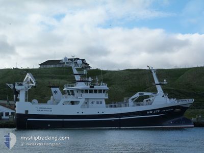
The vessel LINGBANK (IMO: 9816804, MMSI: 219025976) is a Fishing It's sailing under the flag of [DK] Denmark.
In this page you can find informations about the vessels current position, last detected port calls, and current voyage information. If the vessels is not in coverage by AIS you will find the latest position.
The current position of LINGBANK is detected by our AIS receivers and we are not responsible for the reliability of the data. The last position was recorded while the vessel was in Coverage by the Ais receivers of our vessel tracking app.
The current draught of LINGBANK as reported by AIS is 7.4 meters
Weather
| Temperature | 8.6°C / 47.48°F |
|---|---|
| Wind Speed | 13 knots |
| Direction | 313° NW |
| Pressure | 1022.4 hPa |
| Humidity | 90 % |
| Cloud Coverage | 91 % |
Featured Company
Events
| Time | Event | Details | Position / Dest | Info |
|---|---|---|---|---|
| 2024-05-10 04:46 | Status Changed | Engaged in Fishing Under way using engine |
57.02009 / 6.90528
SKAGEN
|
Speed: 9.9 kn Course: 252.8° |
| 2024-05-10 04:46 | Status Changed | Under way using engine Engaged in Fishing |
57.02020 / 6.90592
SKAGEN
|
Speed: 9.9 kn Course: 255.4° |
| 2024-05-10 04:46 | Status Changed | Engaged in Fishing Under way using engine |
57.02036 / 6.90688
SKAGEN
|
Speed: 9.7 kn Course: 263.5° |
| 2024-05-10 04:46 | Status Changed | Under way using engine Engaged in Fishing |
57.02042 / 6.90745
SKAGEN
|
Speed: 9.4 kn Course: 262.4° |
| 2024-05-10 04:45 | Status Changed | Engaged in Fishing Under way using engine |
57.02048 / 6.90841
SKAGEN
|
Speed: 9.2 kn Course: 247.6° |
| 2024-05-10 04:45 | Status Changed | Under way using engine Engaged in Fishing |
57.02052 / 6.90904
SKAGEN
|
Speed: 9.8 kn Course: 233.1° |
| 2024-05-10 04:33 | Status Changed | Engaged in Fishing Under way using engine |
57.04160 / 6.95981
SKAGEN
|
Speed: 10.2 kn Course: 231.7° |
| 2024-05-10 04:33 | Status Changed | Under way using engine Engaged in Fishing |
57.04179 / 6.96028
SKAGEN
|
Speed: 10.2 kn Course: 231.5° |
| 2024-05-10 04:21 | Status Changed | Engaged in Fishing Under way using engine |
57.06492 / 6.99191
SKAGEN
|
Speed: 7.1 kn Course: 219.4° |
| 2024-05-10 04:21 | Status Changed | Under way using engine Engaged in Fishing |
57.06508 / 6.99210
SKAGEN
|
Speed: 7.3 kn Course: 232.6° |