
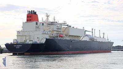
LNG ROSENROT
Tanker D
Current Trip
US CXM
| Time Travelled | 52 days |
|---|---|
| Remaining Time | --- |
| Distance Travelled | 14696.08 nm |
| Remaining Distance | --- |
| AVG Speed | 16.1 Knots |
| MAX Speed | 20.9 Knots |
| AVG Wind | 12.5 knots |
| MAX Wind | 36 knots |
| MIN Temp | 11.2°C / 52.16°F |
| MAX Temp | 30.9°C / 87.62°F |
| Draught | 10.3 m |
| Position Received | 3 d ago |
Current Position
| Longitude | 103.46555° |
|---|---|
| Latitude | 1.21806° |
| Status | Under way using engine |
| Speed | 17 Knots |
| Course | 283° |
| Area | Singapore Strait |
| Station | T-AIS |
| Position Received | 3 d ago |
Info
Information
The current position of LNG ROSENROT is in Singapore Strait with coordinates 1.21806° / 103.46555° as reported on 2024-05-07 03:31 by AIS to our vessel tracker app. The vessel's current speed is 17 Knots
The vessel LNG ROSENROT (IMO: 9877133, MMSI: 538008979) is a Tanker D It's sailing under the flag of [MH] Marshall Is.
In this page you can find informations about the vessels current position, last detected port calls, and current voyage information. If the vessels is not in coverage by AIS you will find the latest position.
The current position of LNG ROSENROT is detected by our AIS receivers and we are not responsible for the reliability of the data. The last position was recorded while the vessel was in Coverage by the Ais receivers of our vessel tracking app.
The current draught of LNG ROSENROT as reported by AIS is 10.3 meters
Weather
| Temperature | 29.6°C / 85.28°F |
|---|---|
| Wind Speed | 3 knots |
| Direction | 244° WSW |
| Pressure | 1008.9 hPa |
| Humidity | 71.4 % |
| Cloud Coverage | 13 % |
Featured Company
Last Port Calls
| Port | Arrival | Departure | Time In Port |
|---|---|---|---|
| 2024-03-17 10:17 | 2024-03-19 09:03 | 1 d |
Most Visited Ports (Last year)
| Port | Arrivals | |
|---|---|---|
| 3 | ||
| 1 | ||
| 1 |
Last Trips
| Origin | Departure | Destination | Arrival | Distance | |
|---|---|---|---|---|---|
| 2024-02-27 22:38 | 2024-03-17 05:17 | 5317.49 nm |
Events
| Time | Event | Details | Position / Dest | Info |
|---|---|---|---|---|
| 2024-05-07 03:36 | Status Changed | Default Under way using engine |
1.22506 / 103.43950
US CXM
|
Speed: 17 kn Course: 283° |
| 2024-05-07 03:31 | OUT of Coverage |
1.21806 / 103.46555
Singapore Strait
|
Speed: 17 kn Course: 283° |
|
| 2024-05-07 03:04 | Change Sea Area | Malaysian part of the Singapore Strait Indonesian part of the Singapore Strait |
1.19187 / 103.58044
Singapore Strait
|
Speed: 14.6 kn Course: 284.8° |
| 2024-05-07 02:34 | Change Sea Area | Indonesian part of the Singapore Strait Singaporean part of the Singapore Strait |
1.17504 / 103.67525
Singapore Strait
|
Speed: 6.2 kn Course: 287.1° |
| 2024-05-07 02:17 | START Moving | 4.9 nm, South West of BUKOM ISLAND |
1.17392 / 103.70089
US CXM
|
Speed: 3.1 kn Course: 259° |
| 2024-05-07 02:11 | ETA Changed | 2024/06/07 05:01 2024/05/06 11:00 |
1.17432 / 103.70437
US CXM
|
Speed: 1.1 kn Course: 281° |
| 2024-05-07 02:09 | Draught Changed | 10.3 9.5 |
1.17404 / 103.70465
US CXM
|
Speed: 0.5 kn Course: 294° |
| 2024-05-07 02:09 | Destination Changed | US CXM SGSIN PGBG |
1.17404 / 103.70465
US CXM
|
Speed: 0.5 kn Course: 294° |
| 2024-05-07 02:06 | Status Changed | Under way using engine At anchor |
1.17383 / 103.70481
SGSIN PGBG
|
Speed: 0.2 kn Course: 307° |
| 2024-05-07 01:28 | Status Changed | At anchor Default |
1.17371 / 103.70484
SGSIN PGBG
|
Speed: Course: -1° |