
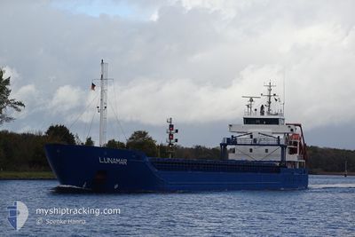
LUNAMAR
General Cargo
Current Trip
| Time Travelled | 1 day |
|---|---|
| Remaining Time | 5 h, 16 mins |
| Distance Travelled | 314.23 nm |
| Remaining Distance | 59.49 nm |
| AVG Speed | 10.6 Knots |
| MAX Speed | 11.3 Knots |
| AVG Wind | 5.5 knots |
| MAX Wind | 8.8 knots |
| MIN Temp | 3.9°C / 39.02°F |
| MAX Temp | 12.1°C / 53.78°F |
| Draught | 6.3 m |
| Position Received | Now |
Current Position
| Longitude | 18.53676° |
|---|---|
| Latitude | 61.30599° |
| Status | Under way using engine |
| Speed | 10.6 Knots |
| Course | 202.6° |
| Area | Gulf of Bothnia |
| Station | T-AIS |
| Position Received | Now |
Info
Information
The current position of LUNAMAR is in Gulf of Bothnia with coordinates 61.30599° / 18.53676° as reported on 2024-05-31 04:38 by AIS to our vessel tracker app. The vessel's current speed is 10.6 Knots and is heading at the port of GAVLE. The estimated time of arrival as calculated by vessel tracking app is 2024-05-31 09:55 LT
The vessel LUNAMAR (IMO: 9551662, MMSI: 255805988) is a General Cargo that was built in 2010 ( 14 years old ). It's sailing under the flag of [PT] Portugal.
In this page you can find informations about the vessels current position, last detected port calls, and current voyage information. If the vessels is not in coverage by AIS you will find the latest position.
The current position of LUNAMAR is detected by our AIS receivers and we are not responsible for the reliability of the data. The last position was recorded while the vessel was in Coverage by the Ais receivers of our vessel tracking app.
The current draught of LUNAMAR as reported by AIS is 6.3 meters
Weather
| Temperature | 9.8°C / 49.64°F |
|---|---|
| Wind Speed | 8 knots |
| Direction | 35° NE |
| Pressure | 1015.1 hPa |
| Humidity | 80.8 % |
| Cloud Coverage | 100 % |
Featured Company
Last Port Calls
| Port | Arrival | Departure | Time In Port |
|---|---|---|---|
| 2024-05-28 19:29 | 2024-05-29 22:30 | 1 d | |
| 2024-05-27 04:09 | 2024-05-28 12:17 | 1 d | |
| 2024-05-23 19:14 | 2024-05-23 19:17 | 3 m | |
| 2024-05-18 08:19 | 2024-05-21 21:30 | 3 d | |
| 2024-05-17 12:58 | 2024-05-17 13:06 | 8 m | |
| 2024-05-14 21:26 | |||
| 2024-05-13 07:23 | 2024-05-13 08:22 | 59 m | |
| 2024-05-07 01:04 | 2024-05-10 09:04 | 3 d | |
| 2024-05-04 03:14 | 2024-05-06 12:12 | 2 d | |
| 2024-05-03 03:56 | 2024-05-03 12:56 | 9 h |
Last Trips
| Origin | Departure | Destination | Arrival | Distance | |
|---|---|---|---|---|---|
| 2024-05-28 14:17 | 2024-05-28 22:29 | 81.47 nm | |||
| 2024-05-23 21:17 | 2024-05-27 06:09 | 905.85 nm | |||
| 2024-05-21 23:30 | 2024-05-23 21:14 | 426.84 nm | |||
| 2024-05-17 15:06 | 2024-05-18 10:19 | 181.56 nm | |||
| 2024-05-13 10:22 | 2024-05-17 14:58 | 342.34 nm | |||
| 2024-05-13 10:22 | 2024-05-14 23:26 | 342.03 nm | |||
| 2024-05-10 11:04 | 2024-05-13 09:23 | 691.49 nm | |||
| 2024-05-06 15:12 | 2024-05-07 03:04 | 141.91 nm | |||
| 2024-05-03 14:56 | 2024-05-04 06:14 | 141.42 nm | |||
| 2024-05-02 21:34 | 2024-05-03 05:56 | 85.33 nm |
Events
| Time | Event | Details | Position / Dest | Info |
|---|---|---|---|---|
| 2024-05-31 04:22 | Status Changed | Under way using engine Default |
61.35088 / 18.57570
GAVLE
|
Speed: 10.8 kn Course: 203° |
| 2024-05-31 04:18 | Status Changed | Default Under way using engine |
61.36150 / 18.58498
GAVLE
|
Speed: 10.8 kn Course: 202° |
| 2024-05-31 04:04 | Status Changed | Under way using engine Default |
61.39968 / 18.61821
GAVLE
|
Speed: 10.8 kn Course: 202° |
| 2024-05-31 03:50 | Status Changed | Default Under way using engine |
61.43844 / 18.65248
GAVLE
|
Speed: 10.9 kn Course: 203.5° |
| 2024-05-31 03:42 | Status Changed | Under way using engine Default |
61.46199 / 18.67390
GAVLE
|
Speed: 10.9 kn Course: 203° |
| 2024-05-31 03:38 | Status Changed | Default Under way using engine |
61.47214 / 18.68322
GAVLE
|
Speed: 10.8 kn Course: 203.3° |
| 2024-05-31 03:13 | Status Changed | Under way using engine Default |
61.54149 / 18.74620
GAVLE
|
Speed: 11 kn Course: 203° |
| 2024-05-31 03:06 | IN Coverage |
61.53919 / 18.74407
Gulf of Bothnia
GAVLE
|
Speed: 11.1 kn Course: 203.6° |
|
| 2024-05-31 00:26 | Status Changed | Default Under way using engine |
62.01405 / 19.17292
GAVLE
|
Speed: 11.1 kn Course: 203.1° |
| 2024-05-31 00:21 | OUT of Coverage |
62.02865 / 19.18656
Gulf of Bothnia
GAVLE
|
Speed: 11.1 kn Course: 203.1° |