
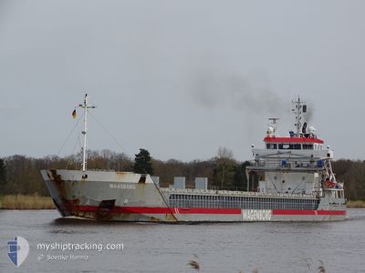
MAASBORG
General Cargo
Current Trip
| Time Travelled | 4 days |
|---|---|
| Remaining Time | --- |
| Distance Travelled | 1214.51 nm |
| Remaining Distance | --- |
| AVG Speed | 11.1 Knots |
| MAX Speed | 14.5 Knots |
| AVG Wind | 8.7 knots |
| MAX Wind | 20.7 knots |
| MIN Temp | 20.9°C / 69.62°F |
| MAX Temp | 28.3°C / 82.94°F |
| Draught | 5.6 m |
| Position Received | 5 h, 22 m ago |
Current Position
| Longitude | 7.18501° |
|---|---|
| Latitude | 37.58896° |
| Status | Under way using engine |
| Speed | 12.1 Knots |
| Course | 266.3° |
| Area | Mediterranean Sea - Western Basin |
| Station | T-AIS |
| Position Received | 5 h, 22 m ago |
Info
Information
The current position of MAASBORG is in Mediterranean Sea - Western Basin with coordinates 37.58896° / 7.18501° as reported on 2024-06-19 14:07 by AIS to our vessel tracker app. The vessel's current speed is 12.1 Knots and is heading at the port of ELLESMERE. The estimated time of arrival as calculated by vessel tracking app is 2024-06-25 13:00 LT
The vessel MAASBORG (IMO: 9341720, MMSI: 244575000) is a General Cargo that was built in 2005 ( 19 years old ). It's sailing under the flag of [NL] Netherlands.
In this page you can find informations about the vessels current position, last detected port calls, and current voyage information. If the vessels is not in coverage by AIS you will find the latest position.
The current position of MAASBORG is detected by our AIS receivers and we are not responsible for the reliability of the data. The last position was recorded while the vessel was in Coverage by the Ais receivers of our vessel tracking app.
The current draught of MAASBORG as reported by AIS is 5.6 meters
Weather
| Temperature | 23.3°C / 73.94°F |
|---|---|
| Wind Speed | 7 knots |
| Direction | 90° E |
| Pressure | 1014.2 hPa |
| Humidity | 79.3 % |
| Cloud Coverage | 100 % |
Featured Company
Last Port Calls
| Port | Arrival | Departure | Time In Port |
|---|---|---|---|
| 2024-06-12 13:51 | 2024-06-15 05:48 | 2 d | |
| 2024-06-10 09:20 | 2024-06-11 14:21 | 1 d | |
| 2024-06-08 05:53 | 2024-06-08 17:21 | 11 h | |
| 2024-06-03 05:59 | 2024-06-04 10:46 | 1 d | |
| 2024-05-22 22:18 | 2024-05-24 04:29 | 1 d | |
| 2024-05-22 06:30 | 2024-05-22 21:26 | 14 h | |
| 2024-05-19 11:01 | 2024-05-20 11:55 | 1 d | |
| 2024-05-12 15:58 | 2024-05-16 16:50 | 4 d | |
| 2024-05-03 21:49 | 2024-05-07 19:58 | 3 d | |
| 2024-05-01 04:16 | 2024-05-03 08:27 | 2 d |
Last Trips
| Origin | Departure | Destination | Arrival | Distance | |
|---|---|---|---|---|---|
| 2024-06-11 17:21 | 2024-06-12 16:51 | 103.99 nm | |||
| 2024-06-08 20:21 | 2024-06-10 12:20 | 67.02 nm | |||
| 2024-06-04 12:46 | 2024-06-08 08:53 | 988.81 nm | |||
| 2024-05-24 06:29 | 2024-06-03 07:59 | 2454.98 nm | |||
| 2024-05-22 23:26 | 2024-05-23 00:18 | 7.29 nm | |||
| 2024-05-20 13:55 | 2024-05-22 08:30 | 395.56 nm | |||
| 2024-05-16 19:50 | 2024-05-19 13:01 | 769.05 nm | |||
| 2024-05-07 21:58 | 2024-05-12 18:58 | 1224.31 nm | |||
| 2024-05-03 10:27 | 2024-05-03 23:49 | 144.43 nm | |||
| 2024-04-29 20:11 | 2024-05-01 06:16 | 314.32 nm |
Events
| Time | Event | Details | Position / Dest | Info |
|---|---|---|---|---|
| 2024-06-19 14:12 | Status Changed | Default Under way using engine |
37.58769 / 7.16329
ELLESMERE-GB
|
Speed: 12.1 kn Course: 266.3° |
| 2024-06-19 14:07 | OUT of Coverage |
37.58896 / 7.18501
Mediterranean Sea - Western Basin
ELLESMERE-GB
|
Speed: 12.1 kn Course: 266.3° |
|
| 2024-06-19 14:04 | Status Changed | Under way using engine Default |
37.58964 / 7.19778
ELLESMERE-GB
|
Speed: 12.1 kn Course: 266° |
| 2024-06-19 13:48 | Status Changed | Default Under way using engine |
37.59373 / 7.26550
ELLESMERE-GB
|
Speed: 12.1 kn Course: 264.9° |
| 2024-06-19 13:39 | Detected in Sea | Algerian part of the Mediterranean Sea - Western Basin |
37.59624 / 7.30219
Mediterranean Sea - Western Basin
ELLESMERE-GB
|
Speed: 12.1 kn Course: 265° |
| 2024-06-19 13:39 | Status Changed | Under way using engine Default |
37.59624 / 7.30219
ELLESMERE-GB
|
Speed: 12.1 kn Course: 266° |
| 2024-06-19 13:21 | IN Coverage |
37.59624 / 7.30219
Mediterranean Sea - Western Basin
ELLESMERE-GB
|
Speed: 12.1 kn Course: 265° |
|
| 2024-06-19 01:25 | Status Changed | Default Under way using engine |
37.65723 / 10.15313
ELLESMERE-GB
|
Speed: 10.6 kn Course: 273.8° |
| 2024-06-19 01:21 | OUT of Coverage |
37.65648 / 10.16944
Mediterranean Sea - Western Basin
ELLESMERE-GB
|
Speed: 10.6 kn Course: 273.8° |
|
| 2024-06-19 00:50 | Status Changed | Under way using engine Default |
37.65063 / 10.28551
ELLESMERE-GB
|
Speed: 10.8 kn Course: 276° |