
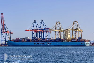
MAERSK LOTA
Container Ship
Current Trip
| Trip Time | 1 day |
|---|---|
| Trip Distance | 73.71 nm |
| AVG Speed | 9.4 Knots |
| MAX Speed | 13.8 Knots |
| Draught | 10 m |
| AVG Wind | 5.7 knots |
| MAX Wind | 10.4 knots |
| MIN Temp | 18.7°C / 65.66°F |
| MAX Temp | 26.8°C / 80.24°F |
| Position Received | 7 h, 18 m ago |
Current Position
| Longitude | -48.45824° |
|---|---|
| Latitude | -25.49420° |
| Status | Under way using engine |
| Speed | 9.3 Knots |
| Course | 269° |
| Area | South Atlantic Ocean |
| Station | T-AIS |
| Position Received | 7 h, 18 m ago |
Info
Information
The current position of MAERSK LOTA is in South Atlantic Ocean with coordinates -25.49420° / -48.45824° as reported on 2024-05-22 16:44 by AIS to our vessel tracker app. The vessel's current speed is 9.3 Knots and is currently inside the port of PARANAGUA.
The vessel MAERSK LOTA (IMO: 9526954, MMSI: 219508000) is a Container Ship that was built in 2012 ( 12 years old ). It's sailing under the flag of [DK] Denmark.
In this page you can find informations about the vessels current position, last detected port calls, and current voyage information. If the vessels is not in coverage by AIS you will find the latest position.
The current position of MAERSK LOTA is detected by our AIS receivers and we are not responsible for the reliability of the data. The last position was recorded while the vessel was in Coverage by the Ais receivers of our vessel tracking app.
The current draught of MAERSK LOTA as reported by AIS is 10 meters
Weather
| Temperature | 19.3°C / 66.74°F |
|---|---|
| Wind Speed | 1 knots |
| Direction | 334° NNW |
| Pressure | 1017.1 hPa |
| Humidity | 97.7 % |
| Cloud Coverage | 83 % |
Featured Company
Last Port Calls
| Port | Arrival | Departure | Time In Port |
|---|---|---|---|
| 2024-05-22 17:09 | |||
| 2024-05-19 16:02 | 2024-05-20 20:12 | 1 d | |
| 2024-05-17 06:34 | 2024-05-17 07:25 | 50 m | |
| 2024-05-13 23:29 | 2024-05-14 13:17 | 13 h | |
| 2024-05-05 05:27 | 2024-05-05 22:11 | 16 h | |
| 2024-05-02 16:42 | 2024-05-03 07:31 | 14 h | |
| 2024-04-29 23:55 | 2024-04-30 20:43 | 20 h | |
| 2024-04-28 21:59 | 2024-04-29 15:14 | 17 h | |
| 2024-04-15 21:08 | 2024-04-16 14:30 | 17 h | |
| 2024-04-15 04:56 | 2024-04-15 05:54 | 58 m |
Last Trips
| Origin | Departure | Destination | Arrival | Distance | |
|---|---|---|---|---|---|
| 2024-05-20 17:12 | 2024-05-22 14:09 | 73.71 nm | |||
| 2024-05-17 04:25 | 2024-05-19 13:02 | 289.06 nm | |||
| 2024-05-14 10:17 | 2024-05-17 03:34 | 1050.77 nm | |||
| 2024-05-05 23:11 | 2024-05-13 20:29 | 3564.85 nm | |||
| 2024-05-03 09:31 | 2024-05-05 06:27 | 138.10 nm | |||
| 2024-04-30 22:43 | 2024-05-02 18:42 | 11.52 nm | |||
| 2024-04-29 16:14 | 2024-04-30 01:55 | 73.78 nm | |||
| 2024-04-16 11:30 | 2024-04-28 22:59 | 4281.15 nm | |||
| 2024-04-15 02:54 | 2024-04-15 18:08 | 196.11 nm | |||
| 2024-04-13 20:47 | 2024-04-15 01:56 | 3.24 nm |
Events
| Time | Event | Details | Position / Dest | Info |
|---|---|---|---|---|
| 2024-05-22 17:11 | STOP Moving |
-25.50013 / -48.49692
[BR] PARANAGUA
|
Speed: 0.1 kn Course: 261° |
|
| 2024-05-22 17:09 | PORT ARRIVAL |
|
-25.50004 / -48.49679
[BR] PARANAGUA
|
Speed: 3 kn Course: 253° |
| 2024-05-22 16:47 | Status Changed | Default Under way using engine |
-25.49427 / -48.46779
BRSSA>BRSSZ
|
Speed: 9.3 kn Course: 269° |
| 2024-05-22 16:44 | OUT of Coverage |
-25.49420 / -48.45824
South Atlantic Ocean
[BR] PARANAGUA
|
Speed: 9.3 kn Course: 269° |
|
| 2024-05-22 16:38 | Status Changed | Under way using engine Default |
-25.49406 / -48.44181
BRSSA>BRSSZ
|
Speed: 10.4 kn Course: 269° |
| 2024-05-22 16:24 | IN Coverage |
-25.49411 / -48.44823
South Atlantic Ocean
|
Speed: 10.2 kn Course: 269.4° |
|
| 2024-05-22 13:41 | START Moving | 13.88 nm, South East of PONTAL DO SUL |
-25.76657 / -48.22926
BRSSA>BRSSZ
|
Speed: 3.7 kn Course: 65° |
| 2024-05-21 00:32 | STOP Moving | 13.75 nm, South East of PONTAL DO SUL |
-25.77017 / -48.24186
BRSSA>BRSSZ
|
Speed: 0.1 kn Course: 169° |
| 2024-05-20 20:15 | START Moving | 0.4 nm, East of ITAPOA |
-26.18689 / -48.59552
BRSSA>BRSSZ
|
Speed: 5.2 kn Course: 72° |
| 2024-05-20 20:12 | PORT DEPARTURE |
|
-26.18764 / -48.59859
BRSSA>BRSSZ
|
Speed: 2.9 kn Course: 260° |