
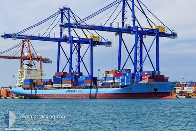
MAERSK NEWPORT
Container Ship
Current Trip
| Time Travelled | 6 days |
|---|---|
| Remaining Time | --- |
| Distance Travelled | 1514.74 nm |
| Remaining Distance | --- |
| AVG Speed | 13.2 Knots |
| MAX Speed | 18.1 Knots |
| AVG Wind | 10.3 knots |
| MAX Wind | 26.1 knots |
| MIN Temp | 15.2°C / 59.36°F |
| MAX Temp | 23.7°C / 74.66°F |
| Draught | 11.3 m |
| Position Received | 1 m ago |
Current Position
| Longitude | 25.76405° |
|---|---|
| Latitude | 39.11033° |
| Status | Under way using engine |
| Speed | 15 Knots |
| Course | 359.2° |
| Area | Aegean Sea |
| Station | T-AIS |
| Position Received | 1 m ago |
Info
Information
The current position of MAERSK NEWPORT is in Aegean Sea with coordinates 39.11033° / 25.76405° as reported on 2024-06-02 00:24 by AIS to our vessel tracker app. The vessel's current speed is 15 Knots and is heading at the port of CONSTANTA. The estimated time of arrival as calculated by vessel tracking app is 2024-06-06 01:00 LT
The vessel MAERSK NEWPORT (IMO: 9356127, MMSI: 219223000) is a Container Ship that was built in 2008 ( 16 years old ). It's sailing under the flag of [DK] Denmark.
In this page you can find informations about the vessels current position, last detected port calls, and current voyage information. If the vessels is not in coverage by AIS you will find the latest position.
The current position of MAERSK NEWPORT is detected by our AIS receivers and we are not responsible for the reliability of the data. The last position was recorded while the vessel was in Coverage by the Ais receivers of our vessel tracking app.
The current draught of MAERSK NEWPORT as reported by AIS is 11.3 meters
Weather
| Temperature | 22°C / 71.6°F |
|---|---|
| Wind Speed | 6 knots |
| Direction | 161° SSE |
| Pressure | 1017 hPa |
| Humidity | 75.4 % |
| Cloud Coverage | 2 % |
Featured Company
Last Port Calls
| Port | Arrival | Departure | Time In Port |
|---|---|---|---|
| 2024-05-30 07:22 | 2024-05-31 09:29 | 1 d | |
| 2024-05-25 18:03 | 2024-05-26 09:09 | 15 h | |
| 2024-05-20 18:36 | 2024-05-22 19:28 | 2 d | |
| 2024-05-14 15:36 | 2024-05-15 10:52 | 19 h | |
| 2024-05-08 11:05 | 2024-05-10 03:58 | 1 d | |
| 2024-05-03 12:22 | 2024-05-04 08:06 | 19 h | |
| 2024-04-30 09:26 | 2024-05-01 01:48 | 16 h | |
| 2024-04-26 20:45 | 2024-04-28 20:40 | 1 d | |
| 2024-04-22 03:07 | 2024-04-22 15:24 | 12 h | |
| 2024-04-20 02:20 |
Last Trips
| Origin | Departure | Destination | Arrival | Distance | |
|---|---|---|---|---|---|
| 2024-05-26 12:09 | 2024-05-30 09:22 | 884.00 nm | |||
| 2024-05-22 22:28 | 2024-05-25 21:03 | 261.79 nm | |||
| 2024-05-10 06:58 | 2024-05-20 21:36 | 2149.57 nm | |||
| 2024-05-10 06:58 | 2024-05-14 17:36 | 1068.82 nm | |||
| 2024-05-01 04:48 | 2024-05-08 14:05 | 1883.61 nm | |||
| 2024-05-01 04:48 | 2024-05-03 14:22 | 822.80 nm | |||
| 2024-04-28 23:40 | 2024-04-30 12:26 | 239.36 nm | |||
| 2024-04-22 18:24 | 2024-04-26 23:45 | 322.37 nm | |||
| 2024-04-13 21:37 | 2024-04-22 06:07 | 1864.20 nm | |||
| 2024-04-03 15:01 | 2024-04-12 01:49 | 1891.54 nm |
Events
| Time | Event | Details | Position / Dest | Info |
|---|---|---|---|---|
| 2024-06-02 00:01 | Status Changed | Under way using engine Default |
39.01368 / 25.76960
EGPSD>>ROCND
|
Speed: 14.9 kn Course: 354° |
| 2024-06-01 23:58 | Status Changed | Default Under way using engine |
39.00330 / 25.77107
EGPSD>>ROCND
|
Speed: 14.9 kn Course: 354.1° |
| 2024-06-01 21:52 | Status Changed | Under way using engine Default |
38.48402 / 25.78240
EGPSD>>ROCND
|
Speed: 14.9 kn Course: 356° |
| 2024-06-01 21:45 | Status Changed | Default Under way using engine |
38.45433 / 25.78472
EGPSD>>ROCND
|
Speed: 15 kn Course: 1.5° |
| 2024-06-01 08:52 | Change Sea Area | Greek part of the Aegean Sea Greek part of the Mediterranean Sea - Eastern Basin |
35.83222 / 27.65410
Aegean Sea
EGPSD>>ROCND
|
Speed: 17.6 kn Course: 324.2° |
| 2024-05-31 23:29 | Change Sea Area | Greek part of the Mediterranean Sea - Eastern Basin Cypriote part of the Mediterranean Sea - Eastern Basin |
33.93198 / 29.99370
Mediterranean Sea - Eastern Basin
EGPSD>>ROCND
|
Speed: 16.2 kn Course: 317.7° |
| 2024-05-31 21:56 | Change Sea Area | Cypriote part of the Mediterranean Sea - Eastern Basin Egyptian part of the Mediterranean Sea - Eastern Basin |
33.62695 / 30.35127
Mediterranean Sea - Eastern Basin
EGPSD>>ROCND
|
Speed: 16.8 kn Course: 315° |
| 2024-05-31 21:47 | Status Changed | Under way using engine Default |
33.59748 / 30.38637
EGPSD>>ROCND
|
Speed: 17.1 kn Course: 313° |
| 2024-05-31 21:42 | Status Changed | Default Under way using engine |
33.58142 / 30.40663
EGPSD>>ROCND
|
Speed: 17.3 kn Course: 314° |
| 2024-05-31 19:22 | Status Changed | Under way using engine Default |
33.12225 / 31.00742
EGPSD>>ROCND
|
Speed: 17.5 kn Course: 314° |