
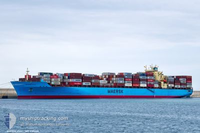
MAERSK UTAH
Container Ship
Current Trip
| Time Travelled | 9 days |
|---|---|
| Remaining Time | --- |
| Distance Travelled | 3497.28 nm |
| Remaining Distance | --- |
| AVG Speed | 15.6 Knots |
| MAX Speed | 15.6 Knots |
| AVG Wind | 11.3 knots |
| MAX Wind | 25.9 knots |
| MIN Temp | 9.5°C / 49.1°F |
| MAX Temp | 22.9°C / 73.22°F |
| Draught | 12.7 m |
| Position Received | Now |
Current Position
| Longitude | 30.77320° |
|---|---|
| Latitude | 32.80844° |
| Status | Under way using engine |
| Speed | 16.2 Knots |
| Course | 104.8° |
| Area | Mediterranean Sea - Eastern Basin |
| Station | T-AIS |
| Position Received | Now |
Info
Information
The current position of MAERSK UTAH is in Mediterranean Sea - Eastern Basin with coordinates 32.80844° / 30.77320° as reported on 2024-06-01 05:28 by AIS to our vessel tracker app. The vessel's current speed is 16.2 Knots and is heading at the port of BREMERHAVEN. The estimated time of arrival as calculated by vessel tracking app is 2024-06-01 19:30 LT
The vessel MAERSK UTAH (IMO: 9305300, MMSI: 563757000) is a Container Ship that was built in 2006 ( 18 years old ). It's sailing under the flag of [SG] Singapore.
In this page you can find informations about the vessels current position, last detected port calls, and current voyage information. If the vessels is not in coverage by AIS you will find the latest position.
The current position of MAERSK UTAH is detected by our AIS receivers and we are not responsible for the reliability of the data. The last position was recorded while the vessel was in Coverage by the Ais receivers of our vessel tracking app.
The current draught of MAERSK UTAH as reported by AIS is 12.7 meters
Weather
| Temperature | 22.6°C / 72.68°F |
|---|---|
| Wind Speed | 7 knots |
| Direction | 132° SE |
| Pressure | 1017.1 hPa |
| Humidity | 77.2 % |
| Cloud Coverage | --- |
Featured Company
Last Port Calls
| Port | Arrival | Departure | Time In Port |
|---|---|---|---|
| 2024-05-21 21:34 | 2024-05-22 23:20 | 1 d | |
| 2024-05-19 14:25 | 2024-05-20 04:06 | 13 h | |
| 2024-05-17 04:20 | 2024-05-17 17:41 | 13 h | |
| 2024-05-15 18:12 | 2024-05-16 12:29 | 18 h | |
| 2024-05-05 00:16 | 2024-05-05 23:46 | 23 h | |
| 2024-05-03 16:15 | 2024-05-04 13:59 | 21 h | |
| 2024-04-25 22:28 | 2024-04-26 14:11 | 15 h | |
| 2024-04-20 16:30 | 2024-04-21 09:17 | 16 h | |
| 2024-04-16 05:58 | 2024-04-17 16:15 | 1 d | |
| 2024-04-11 21:15 | 2024-04-12 09:26 | 12 h |
Last Trips
| Origin | Departure | Destination | Arrival | Distance | |
|---|---|---|---|---|---|
| 2024-05-20 06:06 | 2024-05-21 23:34 | 392.66 nm | |||
| 2024-05-17 19:41 | 2024-05-19 16:25 | 149.98 nm | |||
| 2024-05-16 13:29 | 2024-05-17 06:20 | 155.06 nm | |||
| 2024-05-06 00:46 | 2024-05-15 19:12 | 100.21 nm | |||
| 2024-05-04 15:59 | 2024-05-05 01:16 | 115.31 nm | |||
| 2024-04-26 16:11 | 2024-05-03 18:15 | 1435.35 nm | |||
| 2024-04-21 10:17 | 2024-04-26 00:28 | 1451.34 nm | |||
| 2024-04-17 18:15 | 2024-04-20 17:30 | 128.87 nm | |||
| 2024-04-12 11:26 | 2024-04-16 07:58 | 1418.11 nm | |||
| 2024-04-06 19:31 | 2024-04-11 23:15 | 1489.82 nm |
Events
| Time | Event | Details | Position / Dest | Info |
|---|---|---|---|---|
| 2024-05-31 20:22 | Change Sea Area | Egyptian part of the Mediterranean Sea - Eastern Basin Greek part of the Mediterranean Sea - Eastern Basin |
33.40710 / 28.01840
Mediterranean Sea - Eastern Basin
DEBRV-ILASD
|
Speed: 15.8 kn Course: 103.8° |
| 2024-05-31 19:35 | Draught Changed | 12.7 13.2 |
33.45923 / 27.77165
DEBRV-ILASD
|
Speed: 16.2 kn Course: 104.4° |
| 2024-05-31 19:35 | Destination Changed | DEBRV-ILASD DEBRV-ILASH |
33.45923 / 27.77165
DEBRV-ILASD
|
Speed: 16.2 kn Course: 104.4° |
| 2024-05-31 19:35 | ETA Changed | 2024/06/01 19:30 2024/06/01 18:30 |
33.45923 / 27.77165
DEBRV-ILASD
|
Speed: 16.2 kn Course: 104.4° |
| 2024-05-31 18:36 | Status Changed | Under way using engine Default |
33.52660 / 27.46591
DEBRV-ILASH
|
Speed: 16.1 kn Course: 105° |
| 2024-05-31 18:22 | IN Coverage |
33.52637 / 27.46695
Mediterranean Sea - Eastern Basin
DEBRV-ILASH
|
Speed: 16.2 kn Course: 105° |
|
| 2024-05-31 15:07 | Status Changed | Default Under way using engine |
33.76393 / 26.37467
DEBRV-ILASH
|
Speed: 16.4 kn Course: 105.5° |
| 2024-05-31 15:00 | OUT of Coverage |
33.77231 / 26.33831
Mediterranean Sea - Eastern Basin
DEBRV-ILASH
|
Speed: 16.4 kn Course: 105.5° |
|
| 2024-05-31 09:08 | Status Changed | Under way using engine Default |
34.16941 / 24.49198
DEBRV-ILASH
|
Speed: 16.2 kn Course: 104° |
| 2024-05-31 09:08 | IN Coverage |
34.16666 / 24.50559
Mediterranean Sea - Eastern Basin
DEBRV-ILASH
|
Speed: 16 kn Course: 103.2° |