
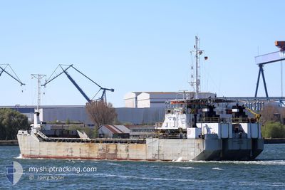
MAGELLANO 1800
Motor Hopper
Current Trip
| Trip Time | 2 days |
|---|---|
| Trip Distance | 350.50 nm |
| AVG Speed | 7.7 Knots |
| MAX Speed | 9.1 Knots |
| Draught | 2.2 m |
| AVG Wind | 11.3 knots |
| MAX Wind | 17 knots |
| MIN Temp | 10.1°C / 50.18°F |
| MAX Temp | 17.3°C / 63.14°F |
| Position Received | 5 m ago |
Current Position
| Longitude | 21.15898° |
|---|---|
| Latitude | 55.65376° |
| Status | Moored |
| Speed | |
| Course | 102° |
| Area | Baltic Sea |
| Station | T-AIS |
| Position Received | 5 m ago |
Info
Information
The current position of MAGELLANO 1800 is in Baltic Sea with coordinates 55.65376° / 21.15898° as reported on 2024-05-28 22:57 by AIS to our vessel tracker app. The vessel's current speed is 0 Knots and is currently inside the port of KLAIPEDA.
The vessel MAGELLANO 1800 (IMO: 7931002, MMSI: 645159000) is a Motor Hopper that was built in 1979 ( 45 years old ). It's sailing under the flag of [MU] Mauritius.
In this page you can find informations about the vessels current position, last detected port calls, and current voyage information. If the vessels is not in coverage by AIS you will find the latest position.
The current position of MAGELLANO 1800 is detected by our AIS receivers and we are not responsible for the reliability of the data. The last position was recorded while the vessel was in Coverage by the Ais receivers of our vessel tracking app.
The current draught of MAGELLANO 1800 as reported by AIS is 2.2 meters
Weather
| Temperature | 14.6°C / 58.28°F |
|---|---|
| Wind Speed | 8 knots |
| Direction | 142° SE |
| Pressure | 1016.3 hPa |
| Humidity | 89.2 % |
| Cloud Coverage | 83 % |
Featured Company
Last Port Calls
| Port | Arrival | Departure | Time In Port |
|---|---|---|---|
| 2024-05-20 05:00 | |||
| 2024-05-16 11:46 | 2024-05-17 06:42 | 18 h | |
| 2024-05-14 11:23 | 2024-05-16 08:44 | 1 d | |
| 2024-05-13 04:31 | 2024-05-13 09:48 | 5 h | |
| 2024-05-05 00:45 | 2024-05-05 01:20 | 35 m | |
| 2024-04-30 04:35 | 2024-04-30 15:58 | 11 h | |
| 2024-04-26 10:21 | 2024-04-26 17:31 | 7 h | |
| 2024-04-19 21:25 | 2024-04-20 04:21 | 6 h | |
| 2024-04-18 21:54 | 2024-04-19 07:59 | 10 h | |
| 2024-04-15 21:39 | 2024-04-16 09:49 | 12 h |
Last Trips
| Origin | Departure | Destination | Arrival | Distance | |
|---|---|---|---|---|---|
| 2024-05-17 08:42 | 2024-05-20 08:00 | 350.50 nm | |||
| 2024-05-16 10:44 | 2024-05-16 13:46 | 23.64 nm | |||
| 2024-05-13 11:48 | 2024-05-14 13:23 | 118.74 nm | |||
| 2024-05-05 03:20 | 2024-05-13 06:31 | 664.91 nm | |||
| 2024-04-30 17:58 | 2024-05-05 02:45 | 437.18 nm | |||
| 2024-04-26 19:31 | 2024-04-30 06:35 | 357.36 nm | |||
| 2024-04-20 06:21 | 2024-04-26 12:21 | 642.19 nm | |||
| 2024-04-19 09:59 | 2024-04-19 23:25 | 53.18 nm | |||
| 2024-04-16 11:49 | 2024-04-18 23:54 | 264.35 nm | |||
| 2024-04-15 19:22 | 2024-04-15 23:39 | 17.62 nm |
Events
| Time | Event | Details | Position / Dest | Info |
|---|---|---|---|---|
| 2024-05-20 06:13 | Status Changed | Moored Under way using engine |
55.65376 / 21.15894
[LT] KLAIPEDA
|
Speed: Course: 102° |
| 2024-05-20 05:44 | STOP Moving |
55.65379 / 21.15870
[LT] KLAIPEDA
|
Speed: 0.3 kn Course: 102° |
|
| 2024-05-20 05:00 | PORT ARRIVAL |
|
55.72423 / 21.09364
[LT] KLAIPEDA
|
Speed: 8.2 kn Course: 121.1° |
| 2024-05-20 04:40 | Change Sea Area | Lithuanian part of the Baltic Sea Swedish part of the Baltic Sea |
55.73322 / 21.01609
Baltic Sea
KLAIPEDA
|
Speed: 7.1 kn Course: 100.2° |
| 2024-05-20 04:38 | IN Coverage |
55.73322 / 21.01609
Baltic Sea
KLAIPEDA
|
Speed: 7.1 kn Course: 100.2° |
|
| 2024-05-19 11:54 | OUT of Coverage |
55.90850 / 17.65490
Baltic Sea
KLAIPEDA
|
Speed: 6.5 kn Course: 82.3° |
|
| 2024-05-19 11:53 | IN Coverage |
55.90765 / 17.65032
Baltic Sea
KLAIPEDA
|
Speed: 6.8 kn Course: 70° |
|
| 2024-05-19 10:05 | OUT of Coverage |
55.85485 / 17.27354
Baltic Sea
KLAIPEDA
|
Speed: 8.2 kn Course: 71.3° |
|
| 2024-05-19 01:59 | Change Sea Area | Swedish part of the Baltic Sea Danish part of the Kattegat |
55.59625 / 15.46154
Baltic Sea
KLAIPEDA
|
Speed: 8.4 kn Course: 84.6° |