
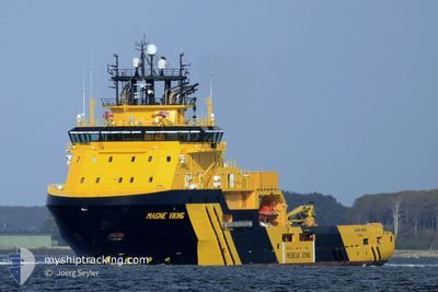
MAGNE VIKING
Anchor Handling Vessel
Current Trip
GBMON
| Time Travelled | 2 days |
|---|---|
| Remaining Time | --- |
| Distance Travelled | 22.50 nm |
| Remaining Distance | --- |
| AVG Speed | 9.7 Knots |
| MAX Speed | 10.6 Knots |
| AVG Wind | 12.6 knots |
| MAX Wind | 17.9 knots |
| MIN Temp | 4.1°C / 39.38°F |
| MAX Temp | 17.3°C / 63.14°F |
| Draught | 6.9 m |
| Position Received | 1 d ago |
Current Position
| Longitude | -2.30521° |
|---|---|
| Latitude | 56.70356° |
| Status | Under way using engine |
| Speed | 10.6 Knots |
| Course | 278° |
| Area | North Sea |
| Station | T-AIS |
| Position Received | 1 d ago |
Info
Information
The current position of MAGNE VIKING is in North Sea with coordinates 56.70356° / -2.30521° as reported on 2024-06-03 19:43 by AIS to our vessel tracker app. The vessel's current speed is 10.6 Knots
The vessel MAGNE VIKING (IMO: 9423839, MMSI: 257061000) is a Anchor Handling Vessel that was built in 2011 ( 13 years old ). It's sailing under the flag of [NO] Norway.
In this page you can find informations about the vessels current position, last detected port calls, and current voyage information. If the vessels is not in coverage by AIS you will find the latest position.
The current position of MAGNE VIKING is detected by our AIS receivers and we are not responsible for the reliability of the data. The last position was recorded while the vessel was in Coverage by the Ais receivers of our vessel tracking app.
The current draught of MAGNE VIKING as reported by AIS is 6.9 meters
Weather
| Temperature | 10.8°C / 51.44°F |
|---|---|
| Wind Speed | 16 knots |
| Direction | 267° W |
| Pressure | 1004.2 hPa |
| Humidity | 58 % |
| Cloud Coverage | 93 % |
Featured Company
Last Trips
Events
| Time | Event | Details | Position / Dest | Info |
|---|---|---|---|---|
| 2024-06-03 20:08 | STOP Moving | 3.08 nm, East of MONTROSE |
56.71167 / -2.37667
GBMON
|
Speed: Course: -1° |
| 2024-06-03 19:50 | Status Changed | Default Under way using engine |
56.70667 / -2.33833
GBMON
|
Speed: 10.6 kn Course: 278° |
| 2024-06-03 19:43 | OUT of Coverage |
56.70356 / -2.30521
North Sea
|
Speed: 10.6 kn Course: 278° |
|
| 2024-06-03 19:42 | Status Changed | Under way using engine Default |
56.70300 / -2.29812
GBMON
|
Speed: 9.3 kn Course: 278° |
| 2024-06-03 19:42 | IN Coverage |
56.70356 / -2.30521
North Sea
|
Speed: 10.6 kn Course: 278° |
|
| 2024-06-03 19:37 | START Moving | 6.48 nm, East of MONTROSE |
56.70094 / -2.27272
GBMON
|
Speed: 9.3 kn Course: 278° |
| 2024-06-03 11:35 | STOP Moving | 7 nm, East of MONTROSE |
56.70148 / -2.25683
GBMON
|
Speed: Course: 228° |
| 2024-06-03 10:44 | PORT DEPARTURE |
|
56.70167 / -2.43167
GBMON
|
Speed: 5.3 kn Course: 87° |
| 2024-06-03 10:35 | START Moving |
56.70240 / -2.46257
[GB] MONTROSE
|
Speed: 5.3 kn Course: 87° |
|
| 2024-06-02 12:41 | OUT of Coverage |
56.70264 / -2.46922
North Sea
[GB] MONTROSE
|
Speed: Course: 226.2° |