
MAIK DEYMANN
Tanker
Current Trip
| Time Travelled | 2 days |
|---|---|
| Remaining Time | 5 h, 27 mins |
| Distance Travelled | 165.02 nm |
| Remaining Distance | 28.53 nm |
| AVG Speed | 5 Knots |
| MAX Speed | 6.5 Knots |
| AVG Wind | 5.6 knots |
| MAX Wind | 16 knots |
| MIN Temp | 7.8°C / 46.04°F |
| MAX Temp | 18°C / 64.4°F |
| Draught | 0.3 m |
| Position Received | Now |
Current Position
| Longitude | 7.92358° |
|---|---|
| Latitude | 49.97208° |
| Status | Under way using engine |
| Speed | 4.8 Knots |
| Course | 102.3° |
| Area | North Sea |
| Station | T-AIS |
| Position Received | Now |
Info
Information
The current position of MAIK DEYMANN is in North Sea with coordinates 49.97208° / 7.92358° as reported on 2024-05-06 09:10 by AIS to our vessel tracker app. The vessel's current speed is 4.8 Knots and is heading at the port of HOCHST. The estimated time of arrival as calculated by vessel tracking app is 2024-05-06 14:38 LT
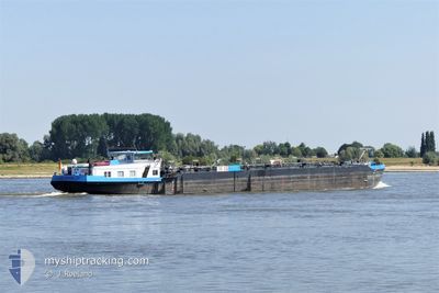
The vessel MAIK DEYMANN (MMSI: 244181288) is a Tanker It's sailing under the flag of [NL] Netherlands.
In this page you can find informations about the vessels current position, last detected port calls, and current voyage information. If the vessels is not in coverage by AIS you will find the latest position.
The current position of MAIK DEYMANN is detected by our AIS receivers and we are not responsible for the reliability of the data. The last position was recorded while the vessel was in Coverage by the Ais receivers of our vessel tracking app.
The current draught of MAIK DEYMANN as reported by AIS is 0.3 meters
Weather
| Temperature | 14.1°C / 57.38°F |
|---|---|
| Wind Speed | 5 knots |
| Direction | 172° S |
| Pressure | 1006.9 hPa |
| Humidity | 92.1 % |
| Cloud Coverage | 100 % |
Featured Company
Last Port Calls
| Port | Arrival | Departure | Time In Port |
|---|---|---|---|
| 2024-05-03 09:45 | 2024-05-03 10:40 | 54 m | |
| 2024-05-02 09:01 | 2024-05-02 09:13 | 12 m | |
| 2024-04-29 12:03 | 2024-05-02 06:07 | 2 d | |
| 2024-04-28 07:00 | 2024-04-29 11:09 | 1 d | |
| 2024-04-28 05:45 | 2024-04-28 06:03 | 17 m | |
| 2024-04-27 07:05 | 2024-04-27 07:27 | 21 m | |
| 2024-04-26 08:14 | 2024-04-26 08:45 | 30 m | |
| 2024-04-25 22:22 | 2024-04-26 06:53 | 8 h | |
| 2024-04-24 12:15 | 2024-04-24 12:40 | 25 m | |
| 2024-04-22 12:41 | 2024-04-22 14:26 | 1 h |
Most Visited Ports (Last year)
| Port | Arrivals | |
|---|---|---|
| 135 | ||
| 46 | ||
| 26 | ||
| 15 | ||
| 15 | ||
| 12 |
Last Trips
| Origin | Departure | Destination | Arrival | Distance | |
|---|---|---|---|---|---|
| 2024-05-02 11:13 | 2024-05-03 11:45 | 99.58 nm | |||
| 2024-05-02 08:07 | 2024-05-02 11:01 | 1.42 nm | |||
| 2024-04-29 13:09 | 2024-04-29 14:03 | 7.64 nm | |||
| 2024-04-28 08:03 | 2024-04-28 09:00 | 10.30 nm | |||
| 2024-04-27 09:27 | 2024-04-28 07:45 | 139.65 nm | |||
| 2024-04-26 10:45 | 2024-04-27 09:05 | 141.24 nm | |||
| 2024-04-26 08:53 | 2024-04-26 10:14 | 9.35 nm | |||
| 2024-04-24 14:40 | 2024-04-26 00:22 | 9.48 nm | |||
| 2024-04-22 16:26 | 2024-04-24 14:15 | 112.24 nm | |||
| 2024-04-21 15:34 | 2024-04-22 14:41 | 71.73 nm |
Events
| Time | Event | Details | Position / Dest | Info |
|---|---|---|---|---|
| 2024-05-06 08:53 | IN Coverage |
49.97273 / 7.88508
North Sea
|
Speed: 3.1 kn Course: 89.8° |
|
| 2024-05-05 09:59 | OUT of Coverage |
50.47337 / 7.34628
North Sea
|
Speed: 4.6 kn Course: 131° |
|
| 2024-05-05 04:01 | START Moving | 1.69 nm, North East of GODORF |
50.86573 / 7.01998
FRANKFURT HOCHST
|
Speed: 5 kn Course: 207.9° |
| 2024-05-05 04:00 | Status Changed | Under way using engine Moored |
50.86745 / 7.02093
FRANKFURT HOCHST
|
Speed: 1.2 kn Course: 511° |
| 2024-05-04 17:17 | Status Changed | Moored Under way using engine |
50.86763 / 7.02119
FRANKFURT HOCHST
|
Speed: 0.1 kn Course: 511° |
| 2024-05-04 16:57 | STOP Moving | 1.8 nm, North East of GODORF |
50.86760 / 7.02113
FRANKFURT HOCHST
|
Speed: 0.1 kn Course: 511° |
| 2024-05-04 04:06 | IN Coverage |
51.52612 / 6.69343
North Sea
|
Speed: 5.7 kn Course: 117.9° |
|
| 2024-05-03 17:38 | OUT of Coverage |
51.52821 / 6.68522
North Sea
|
Speed: 0.1 kn Course: 148.1° |
|
| 2024-05-03 17:28 | STOP Moving | 1.39 nm, North West of WALSUM |
51.52828 / 6.68525
FRANKFURT HOCHST
|
Speed: 0.2 kn Course: 511° |
| 2024-05-03 17:02 | IN Coverage |
51.55804 / 6.68391
North Sea
|
Speed: 5.7 kn Course: 207.5° |