
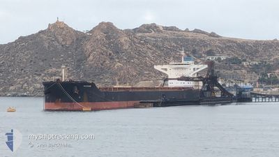
MAIRAKI
Bulk Carrier
Current Trip
| Time Travelled | 4 days |
|---|---|
| Remaining Time | --- |
| Distance Travelled | 1041.03 nm |
| Remaining Distance | --- |
| AVG Speed | 9.1 Knots |
| MAX Speed | 12.3 Knots |
| AVG Wind | 10.9 knots |
| MAX Wind | 19 knots |
| MIN Temp | 16.9°C / 62.42°F |
| MAX Temp | 23.8°C / 74.84°F |
| Draught | 17.9 m |
| Position Received | 7 h, 23 m ago |
Current Position
| Longitude | 151.80868° |
|---|---|
| Latitude | -34.58823° |
| Status | Under way using engine |
| Speed | 9.8 Knots |
| Course | 200.7° |
| Area | Tasman Sea |
| Station | T-AIS |
| Position Received | 7 h, 23 m ago |
Info
Information
The current position of MAIRAKI is in Tasman Sea with coordinates -34.58823° / 151.80868° as reported on 2024-05-28 22:06 by AIS to our vessel tracker app. The vessel's current speed is 9.8 Knots and is heading at the port of ISKENDERUN. The estimated time of arrival as calculated by vessel tracking app is 2024-07-22 12:00 LT
The vessel MAIRAKI (IMO: 9444546, MMSI: 538004073) is a Bulk Carrier that was built in 2011 ( 13 years old ). It's sailing under the flag of [MH] Marshall Is.
In this page you can find informations about the vessels current position, last detected port calls, and current voyage information. If the vessels is not in coverage by AIS you will find the latest position.
The current position of MAIRAKI is detected by our AIS receivers and we are not responsible for the reliability of the data. The last position was recorded while the vessel was in Coverage by the Ais receivers of our vessel tracking app.
The current draught of MAIRAKI as reported by AIS is 17.9 meters
Weather
| Temperature | 19.7°C / 67.46°F |
|---|---|
| Wind Speed | 16 knots |
| Direction | 357° N |
| Pressure | 1023.8 hPa |
| Humidity | 58.3 % |
| Cloud Coverage | 4 % |
Featured Company
Events
| Time | Event | Details | Position / Dest | Info |
|---|---|---|---|---|
| 2024-05-28 22:15 | Status Changed | Default Under way using engine |
-34.61218 / 151.79700
ISDEMIR TURKEY
|
Speed: 9.8 kn Course: 200.7° |
| 2024-05-28 22:06 | OUT of Coverage |
-34.58823 / 151.80868
Tasman Sea
|
Speed: 9.8 kn Course: 200.7° |
|
| 2024-05-28 22:06 | Status Changed | Under way using engine Default |
-34.58780 / 151.80888
ISDEMIR TURKEY
|
Speed: 9.8 kn Course: 203° |
| 2024-05-28 22:04 | Status Changed | Default Under way using engine |
-34.58270 / 151.81134
ISDEMIR TURKEY
|
Speed: 9.8 kn Course: 202.4° |
| 2024-05-28 21:52 | Status Changed | Under way using engine Default |
-34.55358 / 151.82568
ISDEMIR TURKEY
|
Speed: 9.8 kn Course: 202° |
| 2024-05-28 21:47 | Status Changed | Default Under way using engine |
-34.53974 / 151.83270
ISDEMIR TURKEY
|
Speed: 9.7 kn Course: 200.5° |
| 2024-05-28 21:31 | Status Changed | Under way using engine Default |
-34.50133 / 151.85234
ISDEMIR TURKEY
|
Speed: 9.7 kn Course: 203° |
| 2024-05-28 21:27 | Status Changed | Default Under way using engine |
-34.49012 / 151.85829
ISDEMIR TURKEY
|
Speed: 9.7 kn Course: 204.9° |
| 2024-05-28 21:23 | Status Changed | Under way using engine Default |
-34.48009 / 151.86334
ISDEMIR TURKEY
|
Speed: 9 kn Course: 202° |
| 2024-05-28 21:15 | IN Coverage |
-34.48009 / 151.86334
Tasman Sea
|
Speed: 9.7 kn Course: 204.9° |