
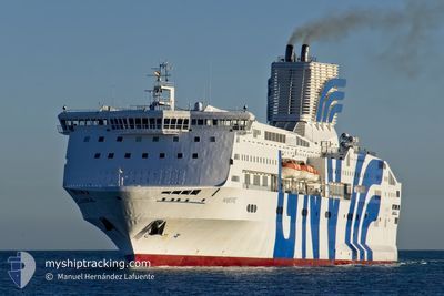
MAJESTIC
Ro-Ro/Passenger Ship
Current Trip
| Time Travelled | 16 h, 57 mins |
|---|---|
| Remaining Time | 3 h, 27 mins |
| Distance Travelled | 348.84 nm |
| Remaining Distance | 71.44 nm |
| AVG Speed | 19.3 Knots |
| MAX Speed | 20.9 Knots |
| AVG Wind | 8.1 knots |
| MAX Wind | 19.4 knots |
| MIN Temp | 18.8°C / 65.84°F |
| MAX Temp | 21.4°C / 70.52°F |
| Draught | 6.6 m |
| Position Received | 3 m ago |
Current Position
| Longitude | 3.47029° |
|---|---|
| Latitude | 41.80945° |
| Status | Under way using engine |
| Speed | 20 Knots |
| Course | 239.5° |
| Area | Mediterranean Sea - Western Basin |
| Station | T-AIS |
| Position Received | 3 m ago |
Info
Information
The current position of MAJESTIC is in Mediterranean Sea - Western Basin with coordinates 41.80945° / 3.47029° as reported on 2024-06-25 05:26 by AIS to our vessel tracker app. The vessel's current speed is 20 Knots and is heading at the port of BARCELONA. The estimated time of arrival as calculated by vessel tracking app is 2024-06-25 08:56 LT
The vessel MAJESTIC (IMO: 9015735, MMSI: 247142000) is a Ro-Ro/Passenger Ship that was built in 1993 ( 31 years old ). It's sailing under the flag of [IT] Italy.
In this page you can find informations about the vessels current position, last detected port calls, and current voyage information. If the vessels is not in coverage by AIS you will find the latest position.
The current position of MAJESTIC is detected by our AIS receivers and we are not responsible for the reliability of the data. The last position was recorded while the vessel was in Coverage by the Ais receivers of our vessel tracking app.
The current draught of MAJESTIC as reported by AIS is 6.6 meters
Weather
| Temperature | 21.4°C / 70.52°F |
|---|---|
| Wind Speed | 9 knots |
| Direction | 250° WSW |
| Pressure | 1011.2 hPa |
| Humidity | 81.6 % |
| Cloud Coverage | 48 % |
Featured Company
Last Port Calls
| Port | Arrival | Departure | Time In Port |
|---|---|---|---|
| 2024-06-24 05:15 | 2024-06-24 12:32 | 7 h | |
| 2024-06-23 04:45 | 2024-06-23 08:32 | 3 h | |
| 2024-06-21 21:44 | 2024-06-22 01:44 | 4 h | |
| 2024-06-11 06:10 | 2024-06-21 16:11 | 10 d | |
| 2024-06-09 09:23 | 2024-06-10 11:17 | 1 d | |
| 2024-06-07 20:22 | 2024-06-07 23:22 | 3 h | |
| 2024-06-06 17:47 | 2024-06-07 00:30 | 6 h | |
| 2024-06-04 10:12 | 2024-06-04 16:27 | 6 h | |
| 2024-06-02 21:29 | 2024-06-03 03:36 | 6 h | |
| 2024-06-01 18:51 | 2024-06-02 01:29 | 6 h |
Most Visited Ports (Last year)
| Port | Arrivals | |
|---|---|---|
| 50 | ||
| 32 | ||
| 30 | ||
| 28 | ||
| 19 | ||
| 19 |
Last Trips
| Origin | Departure | Destination | Arrival | Distance | |
|---|---|---|---|---|---|
| 2024-06-23 10:32 | 2024-06-24 07:15 | 367.75 nm | |||
| 2024-06-22 02:44 | 2024-06-23 06:45 | 536.86 nm | |||
| 2024-06-21 18:11 | 2024-06-21 22:44 | 84.44 nm | |||
| 2024-06-10 12:17 | 2024-06-11 08:10 | 94.97 nm | |||
| 2024-06-08 01:22 | 2024-06-09 10:23 | 535.64 nm | |||
| 2024-06-07 02:30 | 2024-06-07 22:22 | 353.71 nm | |||
| 2024-06-04 17:27 | 2024-06-06 19:47 | 871.62 nm | |||
| 2024-06-03 05:36 | 2024-06-04 11:12 | 536.41 nm | |||
| 2024-06-02 03:29 | 2024-06-02 23:29 | 355.43 nm | |||
| 2024-05-31 17:38 | 2024-06-01 20:51 | 467.39 nm |
Events
| Time | Event | Details | Position / Dest | Info |
|---|---|---|---|---|
| 2024-06-25 04:19 | Change Sea Area | Spanish part of the Mediterranean Sea - Western Basin French part of the Mediterranean Sea - Western Basin |
41.99844 / 3.89246
Mediterranean Sea - Western Basin
ESBCN
|
Speed: 19.6 kn Course: 238.2° |
| 2024-06-25 04:18 | IN Coverage |
41.99844 / 3.89246
Mediterranean Sea - Western Basin
ESBCN
|
Speed: 19.6 kn Course: 238.2° |
|
| 2024-06-24 22:53 | OUT of Coverage |
42.99599 / 6.60161
Mediterranean Sea - Western Basin
ESBCN
|
Speed: 19.2 kn Course: 235.5° |
|
| 2024-06-24 22:53 | IN Coverage |
42.99599 / 6.60161
Mediterranean Sea - Western Basin
ESBCN
|
Speed: 19.2 kn Course: 235.5° |
|
| 2024-06-24 19:29 | Status Changed | Default Under way using engine |
42.97345 / 6.54308
ESBCN
|
Speed: 19.1 kn Course: 235.2° |
| 2024-06-24 19:20 | OUT of Coverage |
43.00392 / 6.61719
Mediterranean Sea - Western Basin
ESBCN
|
Speed: 19.1 kn Course: 235.2° |
|
| 2024-06-24 16:47 | Change Sea Area | French part of the Mediterranean Sea - Western Basin Mon�gasque part of the Mediterranean Sea - Western Basin |
43.48190 / 7.49672
Mediterranean Sea - Western Basin
ESBCN
|
Speed: 19.2 kn Course: 232.2° |
| 2024-06-24 16:40 | Change Sea Area | Mon�gasque part of the Mediterranean Sea - Western Basin French part of the Mediterranean Sea - Western Basin |
43.50503 / 7.53777
Mediterranean Sea - Western Basin
ESBCN
|
Speed: 19.3 kn Course: 232.1° |
| 2024-06-24 16:26 | Change Sea Area | French part of the Mediterranean Sea - Western Basin Italian part of the Mediterranean Sea - Western Basin |
43.55116 / 7.62002
Mediterranean Sea - Western Basin
ESBCN
|
Speed: 19.9 kn Course: 232.4° |
| 2024-06-24 15:53 | Change Sea Area | Italian part of the Mediterranean Sea - Western Basin Italian part of the Ligurian Sea |
43.66067 / 7.81757
Mediterranean Sea - Western Basin
ESBCN
|
Speed: 19.8 kn Course: 232.8° |