
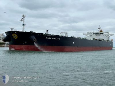
MARE PICENUM
Crude Oil Tanker
Current Trip
| Time Travelled | 8 days |
|---|---|
| Remaining Time | 7 days |
| Distance Travelled | 2309.66 nm |
| Remaining Distance | 2416.07 nm |
| AVG Speed | 11.7 Knots |
| MAX Speed | 16.2 Knots |
| AVG Wind | 9.3 knots |
| MAX Wind | 25 knots |
| MIN Temp | 13°C / 55.4°F |
| MAX Temp | 26.1°C / 78.98°F |
| Draught | 8.8 m |
| Position Received | 3 d ago |
Current Position
| Longitude | -13.76051° |
|---|---|
| Latitude | 27.67169° |
| Status | Under way using engine |
| Speed | 13.2 Knots |
| Course | 217.7° |
| Area | North Atlantic Ocean |
| Station | T-AIS |
| Position Received | 3 d ago |
Info
Information
The current position of MARE PICENUM is in North Atlantic Ocean with coordinates 27.67169° / -13.76051° as reported on 2024-05-16 01:02 by AIS to our vessel tracker app. The vessel's current speed is 13.2 Knots and is heading at the port of LUANDA. The estimated time of arrival as calculated by vessel tracking app is 2024-05-26 22:44 LT
The vessel MARE PICENUM (IMO: 9449405, MMSI: 247293200) is a Crude Oil Tanker that was built in 2011 ( 13 years old ). It's sailing under the flag of [IT] Italy.
In this page you can find informations about the vessels current position, last detected port calls, and current voyage information. If the vessels is not in coverage by AIS you will find the latest position.
The current position of MARE PICENUM is detected by our AIS receivers and we are not responsible for the reliability of the data. The last position was recorded while the vessel was in Coverage by the Ais receivers of our vessel tracking app.
The current draught of MARE PICENUM as reported by AIS is 8.8 meters
Weather
| Temperature | 24°C / 75.2°F |
|---|---|
| Wind Speed | 19 knots |
| Direction | 336° NNW |
| Pressure | 1011.6 hPa |
| Humidity | 79.3 % |
| Cloud Coverage | 4 % |
Featured Company
Last Port Calls
| Port | Arrival | Departure | Time In Port |
|---|---|---|---|
| 2024-05-08 16:44 | 2024-05-10 13:23 | 1 d | |
| 2024-04-15 11:55 | 2024-04-16 14:27 | 1 d | |
| 2024-03-11 09:05 | 2024-03-12 20:55 | 1 d | |
| 2024-03-05 20:25 | 2024-03-06 19:07 | 22 h |
Most Visited Ports (Last year)
| Port | Arrivals | |
|---|---|---|
| 2 | ||
| 2 | ||
| 2 | ||
| 2 | ||
| 1 | ||
| 1 |
Last Trips
| Origin | Departure | Destination | Arrival | Distance | |
|---|---|---|---|---|---|
| 2024-04-16 11:27 | 2024-05-08 18:44 | 5192.82 nm | |||
| 2024-03-12 17:55 | 2024-04-15 08:55 | 4715.94 nm | |||
| 2024-03-06 16:07 | 2024-03-11 06:05 | 4.48 nm | |||
| 2024-01-24 16:19 | 2024-03-05 17:25 | 7853.45 nm |
Events
| Time | Event | Details | Position / Dest | Info |
|---|---|---|---|---|
| 2024-05-16 01:13 | Status Changed | Default Under way using engine |
27.63944 / -13.78842
ANGOLA FOR ORDERS
|
Speed: 13.2 kn Course: 217.7° |
| 2024-05-16 01:02 | OUT of Coverage |
27.67169 / -13.76051
North Atlantic Ocean
ANGOLA FOR ORDERS
|
Speed: 13.2 kn Course: 217.7° |
|
| 2024-05-16 00:58 | Status Changed | Under way using engine Default |
27.68093 / -13.75255
ANGOLA FOR ORDERS
|
Speed: 13.1 kn Course: 217° |
| 2024-05-16 00:53 | Status Changed | Default Under way using engine |
27.69569 / -13.73991
ANGOLA FOR ORDERS
|
Speed: 13.2 kn Course: 216.6° |
| 2024-05-16 00:46 | Change Sea Area | Moroccan part of the North Atlantic Ocean Spanish (Canary Islands) part of the North Atlantic Ocean |
27.71785 / -13.72125
North Atlantic Ocean
ANGOLA FOR ORDERS
|
Speed: 13.1 kn Course: 216.7° |
| 2024-05-16 00:46 | Status Changed | Under way using engine Default |
27.71785 / -13.72125
ANGOLA FOR ORDERS
|
Speed: 13.2 kn Course: 206° |
| 2024-05-16 00:46 | IN Coverage |
27.71785 / -13.72125
North Atlantic Ocean
ANGOLA FOR ORDERS
|
Speed: 13.1 kn Course: 216.7° |
|
| 2024-05-15 23:29 | Status Changed | Default Under way using engine |
27.96769 / -13.57761
ANGOLA FOR ORDERS
|
Speed: 13.1 kn Course: 206.8° |
| 2024-05-15 23:21 | Status Changed | Under way using engine Default |
27.99307 / -13.56296
ANGOLA FOR ORDERS
|
Speed: 13.1 kn Course: 207° |
| 2024-05-15 23:21 | OUT of Coverage |
27.99307 / -13.56296
North Atlantic Ocean
ANGOLA FOR ORDERS
|
Speed: 13.1 kn Course: 206.8° |