
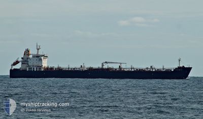
MARIA GLORY
Oil/Chemical Tanker
Current Trip
| Time Travelled | 14 days |
|---|---|
| Remaining Time | --- |
| Distance Travelled | 3609.11 nm |
| Remaining Distance | --- |
| AVG Speed | 11.1 Knots |
| MAX Speed | 11.1 Knots |
| AVG Wind | 11.8 knots |
| MAX Wind | 28.9 knots |
| MIN Temp | 27.2°C / 80.96°F |
| MAX Temp | 35.2°C / 95.36°F |
| Draught | 8 m |
| Position Received | Now |
Current Position
| Longitude | 50.77199° |
|---|---|
| Latitude | 26.15124° |
| Status | At anchor |
| Speed | |
| Course | 350° |
| Area | Persian Gulf |
| Station | T-AIS |
| Position Received | Now |
Info
Information
The current position of MARIA GLORY is in Persian Gulf with coordinates 26.15124° / 50.77199° as reported on 2024-06-26 14:09 by AIS to our vessel tracker app. The vessel's current speed is 0 Knots
The vessel MARIA GLORY (IMO: 9314909, MMSI: 538003855) is a Oil/Chemical Tanker that was built in 2006 ( 18 years old ). It's sailing under the flag of [MH] Marshall Is.
In this page you can find informations about the vessels current position, last detected port calls, and current voyage information. If the vessels is not in coverage by AIS you will find the latest position.
The current position of MARIA GLORY is detected by our AIS receivers and we are not responsible for the reliability of the data. The last position was recorded while the vessel was in Coverage by the Ais receivers of our vessel tracking app.
The current draught of MARIA GLORY as reported by AIS is 8 meters
Weather
| Temperature | 34.8°C / 94.64°F |
|---|---|
| Wind Speed | 12 knots |
| Direction | 335° NNW |
| Pressure | 993.8 hPa |
| Humidity | 59 % |
| Cloud Coverage | --- |
Featured Company
Last Port Calls
| Port | Arrival | Departure | Time In Port |
|---|---|---|---|
| 2024-06-09 06:42 | 2024-06-12 07:24 | 3 d | |
| 2024-05-11 04:51 | 2024-05-15 11:11 | 4 d | |
| 2024-04-04 19:59 | 2024-04-08 15:39 | 3 d |
Last Trips
| Origin | Departure | Destination | Arrival | Distance | |
|---|---|---|---|---|---|
| 2024-05-15 14:11 | 2024-06-09 12:42 | 5311.35 nm | |||
| 2024-04-08 19:39 | 2024-05-11 07:51 | 6445.87 nm | |||
| 2024-03-25 09:01 | 2024-04-04 23:59 | 2885.92 nm |
Events
| Time | Event | Details | Position / Dest | Info |
|---|---|---|---|---|
| 2024-06-26 13:39 | Status Changed | At anchor Default |
26.15122 / 50.77202
BH SIT
|
Speed: Course: 349° |
| 2024-06-26 13:30 | Status Changed | Default At anchor |
26.15125 / 50.77203
BH SIT
|
Speed: Course: 351° |
| 2024-06-26 13:21 | Status Changed | At anchor Default |
26.15124 / 50.77196
BH SIT
|
Speed: Course: 352° |
| 2024-06-26 13:06 | Status Changed | Default At anchor |
26.15123 / 50.77199
BH SIT
|
Speed: Course: 350° |
| 2024-06-26 13:03 | Status Changed | At anchor Default |
26.15121 / 50.77198
BH SIT
|
Speed: Course: 354° |
| 2024-06-26 12:54 | Status Changed | Default At anchor |
26.15118 / 50.77186
BH SIT
|
Speed: Course: 354° |
| 2024-06-26 12:42 | Status Changed | At anchor Default |
26.15121 / 50.77175
BH SIT
|
Speed: Course: 129° |
| 2024-06-26 12:21 | Status Changed | Default At anchor |
26.15121 / 50.77166
BH SIT
|
Speed: Course: 358° |
| 2024-06-26 12:11 | Status Changed | At anchor Default |
26.15120 / 50.77171
BH SIT
|
Speed: Course: 355° |
| 2024-06-26 11:47 | Status Changed | Default At anchor |
26.15124 / 50.77185
BH SIT
|
Speed: Course: 355° |