
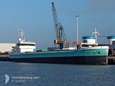
MARIETJE HESTER
General Cargo
Current Trip
| Time Travelled | 3 days |
|---|---|
| Remaining Time | --- |
| Distance Travelled | 341.09 nm |
| Remaining Distance | --- |
| AVG Speed | 10.8 Knots |
| MAX Speed | 11.9 Knots |
| AVG Wind | 7.6 knots |
| MAX Wind | 17 knots |
| MIN Temp | 1.7°C / 35.06°F |
| MAX Temp | 5.6°C / 42.08°F |
| Draught | 5.4 m |
| Position Received | 3 m ago |
Current Position
| Longitude | 26.92195° |
|---|---|
| Latitude | 60.42617° |
| Status | Moored |
| Speed | |
| Course | 309° |
| Area | Gulf of Finland |
| Station | T-AIS |
| Position Received | 3 m ago |
Info
Information
The current position of MARIETJE HESTER is in Gulf of Finland with coordinates 60.42617° / 26.92195° as reported on 2024-05-10 14:33 by AIS to our vessel tracker app. The vessel's current speed is 0 Knots
The vessel MARIETJE HESTER (IMO: 9279032, MMSI: 244482000) is a General Cargo that was built in 2005 ( 19 years old ). It's sailing under the flag of [NL] Netherlands.
In this page you can find informations about the vessels current position, last detected port calls, and current voyage information. If the vessels is not in coverage by AIS you will find the latest position.
The current position of MARIETJE HESTER is detected by our AIS receivers and we are not responsible for the reliability of the data. The last position was recorded while the vessel was in Coverage by the Ais receivers of our vessel tracking app.
The current draught of MARIETJE HESTER as reported by AIS is 5.4 meters
Weather
| Temperature | 10.4°C / 50.72°F |
|---|---|
| Wind Speed | 13 knots |
| Direction | 320° NW |
| Pressure | 1010 hPa |
| Humidity | 42.7 % |
| Cloud Coverage | 21 % |
Featured Company
Last Port Calls
| Port | Arrival | Departure | Time In Port |
|---|---|---|---|
| 2024-05-05 07:44 | 2024-05-07 10:03 | 2 d | |
| 2024-04-28 12:40 | 2024-04-29 15:28 | 1 d | |
| 2024-04-27 18:43 | 2024-04-28 03:27 | 8 h | |
| 2024-04-23 13:40 | 2024-04-23 19:41 | 6 h | |
| 2024-04-08 06:18 | 2024-04-09 15:01 | 1 d | |
| 2024-04-08 04:58 | 2024-04-08 05:18 | 20 m | |
| 2024-04-03 16:42 | 2024-04-04 15:42 | 23 h | |
| 2024-04-01 05:01 | 2024-04-02 17:30 | 1 d | |
| 2024-03-28 07:39 | 2024-03-28 21:55 | 14 h | |
| 2024-03-26 16:03 | 2024-03-27 22:59 | 1 d |
Last Trips
| Origin | Departure | Destination | Arrival | Distance | |
|---|---|---|---|---|---|
| 2024-04-29 17:28 | 2024-05-05 09:44 | 1016.84 nm | |||
| 2024-04-28 05:27 | 2024-04-28 14:40 | 96.57 nm | |||
| 2024-04-23 22:41 | 2024-04-27 20:43 | 919.82 nm | |||
| 2024-04-09 16:01 | 2024-04-23 16:40 | 2112.17 nm | |||
| 2024-04-08 06:18 | 2024-04-08 07:18 | 4.77 nm | |||
| 2024-04-04 17:42 | 2024-04-08 05:58 | 660.96 nm | |||
| 2024-04-02 18:30 | 2024-04-03 18:42 | 250.73 nm | |||
| 2024-03-28 21:55 | 2024-04-01 06:01 | 704.12 nm | |||
| 2024-03-27 22:59 | 2024-03-28 07:39 | 79.59 nm | |||
| 2024-03-19 23:06 | 2024-03-26 16:03 | 947.63 nm |
Events
| Time | Event | Details | Position / Dest | Info |
|---|---|---|---|---|
| 2024-05-10 14:30 | Status Changed | Moored Default |
60.42616 / 26.92199
NLAMS
|
Speed: Course: 309° |
| 2024-05-10 14:24 | Status Changed | Default Moored |
60.42616 / 26.92188
NLAMS
|
Speed: Course: 309° |
| 2024-05-10 13:27 | Status Changed | Moored Default |
60.42608 / 26.92193
NLAMS
|
Speed: Course: 309° |
| 2024-05-10 13:18 | Status Changed | Default Moored |
60.42603 / 26.92181
NLAMS
|
Speed: Course: 309° |
| 2024-05-10 10:57 | Status Changed | Moored Default |
60.42607 / 26.92184
NLAMS
|
Speed: Course: 310° |
| 2024-05-10 10:54 | Status Changed | Default Moored |
60.42613 / 26.92186
NLAMS
|
Speed: Course: 309° |
| 2024-05-10 10:22 | Status Changed | Moored Default |
60.42617 / 26.92184
NLAMS
|
Speed: Course: 309° |
| 2024-05-10 10:10 | Status Changed | Default Moored |
60.42612 / 26.92177
NLAMS
|
Speed: 0.1 kn Course: 309° |
| 2024-05-10 09:34 | Status Changed | Moored Default |
60.42610 / 26.92176
NLAMS
|
Speed: Course: 309° |
| 2024-05-10 09:31 | Status Changed | Default Moored |
60.42610 / 26.92179
NLAMS
|
Speed: Course: 309° |