
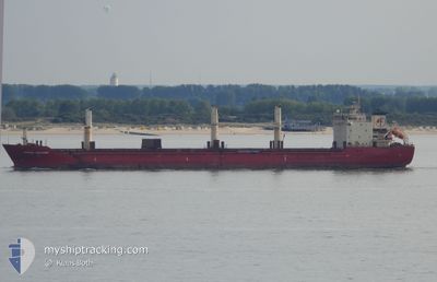
MERCURY J
Bulk Carrier
Current Trip
| Time Travelled | 3 days |
|---|---|
| Remaining Time | --- |
| Distance Travelled | 474.19 nm |
| Remaining Distance | --- |
| AVG Speed | 7.8 Knots |
| MAX Speed | 7.8 Knots |
| AVG Wind | 6.1 knots |
| MAX Wind | 14.9 knots |
| MIN Temp | 16.8°C / 62.24°F |
| MAX Temp | 23.6°C / 74.48°F |
| Draught | 10.3 m |
| Position Received | Now |
Current Position
| Longitude | 29.13874° |
|---|---|
| Latitude | 41.25570° |
| Status | Under way using engine |
| Speed | 4.7 Knots |
| Course | 196° |
| Area | Black Sea |
| Station | T-AIS |
| Position Received | Now |
Info
Information
The current position of MERCURY J is in Black Sea with coordinates 41.25570° / 29.13874° as reported on 2024-05-31 08:41 by AIS to our vessel tracker app. The vessel's current speed is 4.7 Knots and is heading at the port of DAMIETTA. The estimated time of arrival as calculated by vessel tracking app is 2024-06-02 15:00 LT
The vessel MERCURY J (IMO: 9299472, MMSI: 511100372) is a Bulk Carrier that was built in 2005 ( 19 years old ). It's sailing under the flag of [PW] Palau.
In this page you can find informations about the vessels current position, last detected port calls, and current voyage information. If the vessels is not in coverage by AIS you will find the latest position.
The current position of MERCURY J is detected by our AIS receivers and we are not responsible for the reliability of the data. The last position was recorded while the vessel was in Coverage by the Ais receivers of our vessel tracking app.
The current draught of MERCURY J as reported by AIS is 10.3 meters
Weather
| Temperature | 23.4°C / 74.12°F |
|---|---|
| Wind Speed | 1 knots |
| Direction | 355° N |
| Pressure | 1014.1 hPa |
| Humidity | 57.7 % |
| Cloud Coverage | --- |
Featured Company
Last Port Calls
| Port | Arrival | Departure | Time In Port |
|---|---|---|---|
| 2024-05-26 08:34 | 2024-05-27 15:01 | 1 d | |
| 2024-05-06 06:46 | 2024-05-11 18:38 | 5 d | |
| 2024-04-24 22:17 | |||
| 2024-04-09 12:21 | 2024-04-14 20:30 | 5 d | |
| 2024-04-01 21:35 | 2024-04-02 14:49 | 17 h | |
| 2024-03-23 21:49 | 2024-03-26 17:41 | 2 d | |
| 2024-03-23 21:42 | 2024-03-23 21:44 | 1 m | |
| 2024-03-22 04:33 | 2024-03-23 21:35 | 1 d | |
| 2024-03-21 10:49 | 2024-03-22 04:27 | 17 h | |
| 2024-03-21 08:03 | 2024-03-21 10:48 | 2 h |
Most Visited Ports (Last year)
| Port | Arrivals | |
|---|---|---|
| 5 | ||
| 4 | ||
| 4 | ||
| 3 | ||
| 2 | ||
| 2 |
Last Trips
| Origin | Departure | Destination | Arrival | Distance | |
|---|---|---|---|---|---|
| 2024-05-11 21:38 | 2024-05-26 11:34 | 1660.08 nm | |||
| 2024-04-25 00:17 | 2024-05-06 09:46 | 517.56 nm | |||
| 2024-04-02 16:49 | 2024-04-09 14:21 | 37.11 nm | |||
| 2024-03-26 19:41 | 2024-04-01 23:35 | 1121.44 nm | |||
| 2024-03-23 23:44 | 2024-03-23 23:49 | 1.05 nm | |||
| 2024-03-23 23:35 | 2024-03-23 23:42 | 4.08 nm | |||
| 2024-03-22 06:27 | 2024-03-22 06:33 | 1.25 nm | |||
| 2024-03-21 12:48 | 2024-03-21 12:49 | 0.52 nm | |||
| 2024-03-13 12:25 | 2024-03-21 10:03 | 1245.10 nm | |||
| 2024-03-03 21:19 | 2024-03-09 10:27 | 12.45 nm |
Events
| Time | Event | Details | Position / Dest | Info |
|---|---|---|---|---|
| 2024-05-31 06:25 | START Moving | 13.41 nm, North East of RUMELI FENERI |
41.43415 / 29.23805
EG DAM
|
Speed: 3.3 kn Course: 210° |
| 2024-05-30 16:48 | STOP Moving | 14.48 nm, North of RUMELI FENERI |
41.46867 / 29.17258
EG DAM
|
Speed: 0.3 kn Course: 219° |
| 2024-05-30 14:55 | Detected in Sea | Turkish part of the Black Sea |
41.49748 / 29.48159
Black Sea
EG DAM
|
Speed: 9.8 kn Course: 242.9° |
| 2024-05-30 14:54 | Status Changed | Under way using engine Default |
41.49877 / 29.48481
EG DAM
|
Speed: 9.7 kn Course: 243° |
| 2024-05-30 14:36 | IN Coverage |
41.49748 / 29.48159
Black Sea
EG DAM
|
Speed: 9.8 kn Course: 242.9° |
|
| 2024-05-29 02:17 | Status Changed | Default Under way using engine |
44.14238 / 37.46975
EG DAM
|
Speed: 10.6 kn Course: 244.2° |
| 2024-05-29 02:15 | Status Changed | Under way using engine Default |
44.14537 / 37.47834
EG DAM
|
Speed: 10.7 kn Course: 244° |
| 2024-05-29 02:15 | OUT of Coverage |
44.14537 / 37.47834
Black Sea
EG DAM
|
Speed: 10.6 kn Course: 244.2° |
|
| 2024-05-29 02:03 | Status Changed | Default Under way using engine |
44.16044 / 37.52177
EG DAM
|
Speed: 10.7 kn Course: 245.3° |
| 2024-05-29 00:54 | OUT of Coverage |
44.26833 / 37.75645
Black Sea
EG DAM
|
Speed: 10 kn Course: 233.4° |