
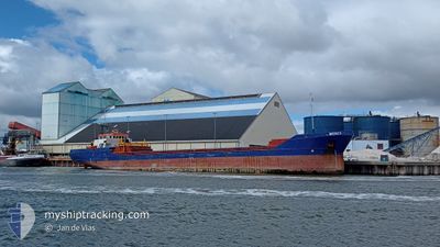
MERCY
General Cargo
Current Trip
| Time Travelled | 2 days |
|---|---|
| Remaining Time | 16 h, 24 mins |
| Distance Travelled | 366.82 nm |
| Remaining Distance | 151.26 nm |
| AVG Speed | 8.6 Knots |
| MAX Speed | 8.6 Knots |
| AVG Wind | 6.6 knots |
| MAX Wind | 14 knots |
| MIN Temp | 24.6°C / 76.28°F |
| MAX Temp | 31.5°C / 88.7°F |
| Draught | 5.4 m |
| Position Received | 3 h, 3 m ago |
Current Position
| Longitude | 27.62454° |
|---|---|
| Latitude | 36.51069° |
| Status | Under way using engine |
| Speed | 7.8 Knots |
| Course | 276.6° |
| Area | Aegean Sea |
| Station | T-AIS |
| Position Received | 3 h, 3 m ago |
Info
Information
The current position of MERCY is in Aegean Sea with coordinates 36.51069° / 27.62454° as reported on 2024-06-13 01:57 by AIS to our vessel tracker app. The vessel's current speed is 7.8 Knots and is heading at the port of VOUDIA. The estimated time of arrival as calculated by vessel tracking app is 2024-06-13 21:24 LT
The vessel MERCY (IMO: 9148104, MMSI: 305226000) is a General Cargo that was built in 1996 ( 28 years old ). It's sailing under the flag of [AG] Antigua Barbuda.
In this page you can find informations about the vessels current position, last detected port calls, and current voyage information. If the vessels is not in coverage by AIS you will find the latest position.
The current position of MERCY is detected by our AIS receivers and we are not responsible for the reliability of the data. The last position was recorded while the vessel was in Coverage by the Ais receivers of our vessel tracking app.
The current draught of MERCY as reported by AIS is 5.4 meters
Weather
| Temperature | 24.3°C / 75.74°F |
|---|---|
| Wind Speed | 8 knots |
| Direction | 287° WNW |
| Pressure | 1012 hPa |
| Humidity | 78.2 % |
| Cloud Coverage | 4 % |
Featured Company
Last Port Calls
| Port | Arrival | Departure | Time In Port |
|---|---|---|---|
| 2024-06-10 09:16 | 2024-06-11 04:25 | 19 h | |
| 2024-05-28 06:45 | 2024-05-28 17:57 | 11 h | |
| 2024-05-27 04:49 | 2024-05-27 11:33 | 6 h | |
| 2024-05-18 13:06 | 2024-05-22 17:21 | 4 d | |
| 2024-05-11 17:24 | 2024-05-14 17:02 | 2 d | |
| 2024-04-24 00:21 | 2024-04-24 21:00 | 20 h | |
| 2024-04-20 03:33 | 2024-04-20 15:30 | 11 h | |
| 2024-04-15 20:04 | 2024-04-16 19:24 | 23 h | |
| 2024-04-14 14:15 | 2024-04-15 19:25 | 1 d | |
| 2024-04-14 13:16 | 2024-04-14 14:01 | 45 m |
Last Trips
| Origin | Departure | Destination | Arrival | Distance | |
|---|---|---|---|---|---|
| 2024-05-28 19:57 | 2024-06-10 12:16 | 1361.87 nm | |||
| 2024-05-27 13:33 | 2024-05-28 08:45 | 150.82 nm | |||
| 2024-05-22 20:21 | 2024-05-27 06:49 | 672.09 nm | |||
| 2024-05-14 19:02 | 2024-05-18 16:06 | 470.78 nm | |||
| 2024-04-24 23:00 | 2024-05-11 19:24 | 3008.50 nm | |||
| 2024-04-20 16:30 | 2024-04-24 02:21 | 693.33 nm | |||
| 2024-04-16 21:24 | 2024-04-20 04:33 | 577.88 nm | |||
| 2024-04-15 21:25 | 2024-04-15 22:04 | 3.89 nm | |||
| 2024-04-14 16:01 | 2024-04-14 16:15 | 0.34 nm | |||
| 2024-04-08 22:18 | 2024-04-14 15:16 | 639.41 nm |
Events
| Time | Event | Details | Position / Dest | Info |
|---|---|---|---|---|
| 2024-06-13 02:10 | Status Changed | Default Under way using engine |
36.51433 / 27.58792
VOUDIA BAY
|
Speed: 7.8 kn Course: 276.6° |
| 2024-06-13 01:57 | OUT of Coverage |
36.51069 / 27.62454
Aegean Sea
VOUDIA BAY
|
Speed: 7.8 kn Course: 276.6° |
|
| 2024-06-13 00:59 | Status Changed | Under way using engine Default |
36.50222 / 27.78362
VOUDIA BAY
|
Speed: 8 kn Course: 272° |
| 2024-06-13 00:48 | Status Changed | Default Under way using engine |
36.50095 / 27.81381
VOUDIA BAY
|
Speed: 8 kn Course: 272° |
| 2024-06-13 00:01 | Detected in Sea | Greek part of the Aegean Sea |
36.49542 / 27.94262
Aegean Sea
VOUDIA BAY
|
Speed: 7.8 kn Course: 268.7° |
| 2024-06-13 00:01 | Status Changed | Under way using engine Default |
36.49542 / 27.94262
VOUDIA BAY
|
Speed: 7.6 kn Course: 269° |
| 2024-06-12 23:53 | Status Changed | Default Under way using engine |
36.49575 / 27.96375
VOUDIA BAY
|
Speed: 7.3 kn Course: 269.2° |
| 2024-06-12 23:45 | Detected in Sea | Turkish part of the Aegean Sea |
36.49600 / 27.98421
Aegean Sea
VOUDIA BAY
|
Speed: 7.3 kn Course: 269.2° |
| 2024-06-12 23:45 | Status Changed | Under way using engine Default |
36.49600 / 27.98459
VOUDIA BAY
|
Speed: 7.2 kn Course: 269° |
| 2024-06-12 23:41 | IN Coverage |
36.49600 / 27.98421
Aegean Sea
VOUDIA BAY
|
Speed: 7.3 kn Course: 269.2° |