
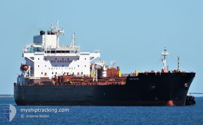
MERSEY
Tanker
Current Trip
BR SUA
| Time Travelled | 13 days |
|---|---|
| Remaining Time | --- |
| Distance Travelled | 1931.10 nm |
| Remaining Distance | --- |
| AVG Speed | 9.1 Knots |
| MAX Speed | 13.3 Knots |
| AVG Wind | 13.5 knots |
| MAX Wind | 32.6 knots |
| MIN Temp | 12.3°C / 54.14°F |
| MAX Temp | 29.1°C / 84.38°F |
| Draught | 7.4 m |
| Position Received | 9 d ago |
Current Position
| Longitude | -42.25920° |
|---|---|
| Latitude | -23.77932° |
| Status | Under way using engine |
| Speed | 12.1 Knots |
| Course | 231.9° |
| Area | South Atlantic Ocean |
| Station | T-AIS |
| Position Received | 9 d ago |
Info
Information
The current position of MERSEY is in South Atlantic Ocean with coordinates -23.77932° / -42.25920° as reported on 2024-05-24 07:43 by AIS to our vessel tracker app. The vessel's current speed is 12.1 Knots
The vessel MERSEY (IMO: 9865752, MMSI: 538008664) is a Tanker It's sailing under the flag of [MH] Marshall Is.
In this page you can find informations about the vessels current position, last detected port calls, and current voyage information. If the vessels is not in coverage by AIS you will find the latest position.
The current position of MERSEY is detected by our AIS receivers and we are not responsible for the reliability of the data. The last position was recorded while the vessel was in Coverage by the Ais receivers of our vessel tracking app.
The current draught of MERSEY as reported by AIS is 7.4 meters
Weather
| Temperature | 19.8°C / 67.64°F |
|---|---|
| Wind Speed | 19 knots |
| Direction | 4° N |
| Pressure | 1019.3 hPa |
| Humidity | 88.6 % |
| Cloud Coverage | 7 % |
Featured Company
Last Port Calls
Last Trips
| Origin | Departure | Destination | Arrival | Distance | |
|---|---|---|---|---|---|
| 2024-05-14 23:46 | 2024-05-18 10:13 | 869.49 nm | |||
| 2024-05-08 07:03 | 2024-05-12 23:01 | 36.62 nm | |||
| 2024-04-13 16:31 | 2024-05-05 05:20 | 3579.77 nm | |||
| 2024-04-04 22:02 | 2024-04-10 15:30 | 463.89 nm | |||
| 2024-04-02 02:38 | 2024-04-03 14:10 | 4.47 nm |
Events
| Time | Event | Details | Position / Dest | Info |
|---|---|---|---|---|
| 2024-06-02 14:53 | START Moving | 3.37 nm, South East of TRAMANDAI |
-30.01906 / -50.09379
BR SUA
|
Speed: 3.6 kn Course: 70° |
| 2024-05-31 14:17 | STOP Moving | 3.75 nm, South East of TRAMANDAI |
-30.03060 / -50.09668
BR SUA
|
Speed: 0.3 kn Course: 335° |
| 2024-05-30 23:18 | START Moving | 12.27 nm, North East of TRAMANDAI |
-29.83177 / -49.98506
BR SUA
|
Speed: 3.1 kn Course: 164° |
| 2024-05-30 21:36 | STOP Moving | 12.63 nm, North East of TRAMANDAI |
-29.83909 / -49.96677
BR SUA
|
Speed: 0.3 kn Course: 59° |
| 2024-05-29 11:26 | START Moving | 4.84 nm, North East of TRAMANDAI |
-29.93741 / -50.06709
BR SUA
|
Speed: 4.5 kn Course: 86° |
| 2024-05-29 10:05 | STOP Moving | 3.7 nm, East of TRAMANDAI |
-29.96578 / -50.07563
BR SUA
|
Speed: 0.2 kn Course: 54° |
| 2024-05-29 09:30 | START Moving | 3.74 nm, East of TRAMANDAI |
-29.96512 / -50.07487
BR SUA
|
Speed: 3.5 kn Course: 44° |
| 2024-05-26 22:32 | STOP Moving | 3.87 nm, East of TRAMANDAI |
-29.96370 / -50.07294
BR SUA
|
Speed: 0.2 kn Course: 170° |
| 2024-05-24 07:49 | Status Changed | Default Under way using engine |
-23.79032 / -42.27284
BR SUA
|
Speed: 12.1 kn Course: 231.9° |
| 2024-05-24 07:43 | OUT of Coverage |
-23.77932 / -42.25920
South Atlantic Ocean
|
Speed: 12.1 kn Course: 231.9° |