
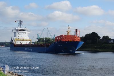
MILA
General Cargo
Current Position
| Longitude | 16.79670° |
|---|---|
| Latitude | 55.18688° |
| Status | Under way using engine |
| Speed | 10.5 Knots |
| Course | 65.9° |
| Area | Baltic Sea |
| Station | T-AIS |
| Position Received | 1 d ago |
Info
Information
The current position of MILA is in Baltic Sea with coordinates 55.18688° / 16.79670° as reported on 2024-06-06 02:03 by AIS to our vessel tracker app. The vessel's current speed is 10.5 Knots and is currently inside the port of LIEPAJA.
The vessel MILA (IMO: 9501681, MMSI: 305836000) is a General Cargo that was built in 2013 ( 11 years old ). It's sailing under the flag of [AG] Antigua Barbuda.
In this page you can find informations about the vessels current position, last detected port calls, and current voyage information. If the vessels is not in coverage by AIS you will find the latest position.
The current position of MILA is detected by our AIS receivers and we are not responsible for the reliability of the data. The last position was recorded while the vessel was in Coverage by the Ais receivers of our vessel tracking app.
The current draught of MILA as reported by AIS is 5.3 meters
Weather
| Temperature | 14°C / 57.2°F |
|---|---|
| Wind Speed | 8 knots |
| Direction | 242° WSW |
| Pressure | 1017.6 hPa |
| Humidity | 65.4 % |
| Cloud Coverage | 10 % |
Featured Company
Last Port Calls
| Port | Arrival | Departure | Time In Port |
|---|---|---|---|
| 2024-05-09 07:39 | 2024-05-13 15:21 | 4 d | |
| 2024-05-02 16:19 | 2024-05-07 03:16 | 4 d | |
| 2024-04-28 17:12 | 2024-04-29 15:29 | 22 h | |
| 2024-04-24 00:22 | 2024-04-26 19:03 | 2 d | |
| 2024-04-17 22:33 | 2024-04-19 15:20 | 1 d | |
| 2024-04-06 19:14 | 2024-04-09 22:38 | 3 d | |
| 2024-04-02 12:50 |
Most Visited Ports (Last year)
| Port | Arrivals | |
|---|---|---|
| 3 | ||
| 2 | ||
| 2 | ||
| 2 | ||
| 1 | ||
| 1 |
Last Trips
| Origin | Departure | Destination | Arrival | Distance | |
|---|---|---|---|---|---|
| 2024-05-07 05:16 | 2024-05-09 09:39 | 519.25 nm | |||
| 2024-04-29 18:29 | 2024-05-02 18:19 | 586.54 nm | |||
| 2024-04-26 21:03 | 2024-04-28 20:12 | 513.80 nm | |||
| 2024-04-19 18:20 | 2024-04-24 02:22 | 647.01 nm | |||
| 2024-04-10 00:38 | 2024-04-18 01:33 | 1889.32 nm | |||
| 2024-04-02 14:50 | 2024-04-06 21:14 | 790.12 nm |
Events
| Time | Event | Details | Position / Dest | Info |
|---|---|---|---|---|
| 2024-06-06 02:03 | OUT of Coverage |
55.18688 / 16.79670
Baltic Sea
LVLPX
|
Speed: 10.5 kn Course: 65.9° |
|
| 2024-06-05 18:24 | ETA Changed | 2024/06/06 17:00 2024/06/06 15:00 |
54.36774 / 14.99629
LVLPX
|
Speed: 10.3 kn Course: 45.1° |
| 2024-06-05 17:19 | Destination Changed | LVLPX FOR ORDER |
54.23731 / 14.77234
LVLPX
|
Speed: 10.2 kn Course: 46° |
| 2024-06-05 17:19 | ETA Changed | 2024/06/06 15:00 2025/05/28 22:00 |
54.23731 / 14.77234
LVLPX
|
Speed: 10.2 kn Course: 46° |
| 2024-06-05 16:30 | IN Coverage |
54.14429 / 14.60567
Baltic Sea
|
Speed: 10.2 kn Course: 47.1° |
|
| 2024-06-05 15:17 | START Moving | 6.3 nm, North East of SWINOUJSCIE |
53.99909 / 14.33830
FOR ORDER
|
Speed: 10.4 kn Course: 48° |
| 2024-06-05 07:08 | Status Changed | Default At anchor |
53.97016 / 14.30870
FOR ORDER
|
Speed: Course: 218° |
| 2024-06-05 06:59 | OUT of Coverage |
53.97024 / 14.30851
Baltic Sea
|
Speed: Course: 169.2° |
|
| 2024-06-05 04:44 | Status Changed | At anchor Default |
53.97041 / 14.30778
FOR ORDER
|
Speed: Course: 193° |
| 2024-06-05 04:38 | Status Changed | Default At anchor |
53.97044 / 14.30769
FOR ORDER
|
Speed: Course: 192° |