
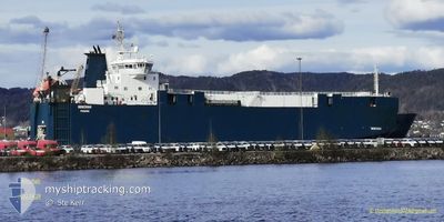
MINCHAH
Vehicles Carrier
Current Trip
| Time Travelled | 5 days |
|---|---|
| Remaining Time | 3 h, 52 mins |
| Distance Travelled | 1082.73 nm |
| Remaining Distance | 34.95 nm |
| AVG Speed | 12.2 Knots |
| MAX Speed | 16.2 Knots |
| AVG Wind | 8 knots |
| MAX Wind | 19.8 knots |
| MIN Temp | 24.6°C / 76.28°F |
| MAX Temp | 29.7°C / 85.46°F |
| Draught | 4.9 m |
| Position Received | Now |
Current Position
| Longitude | -79.50683° |
|---|---|
| Latitude | 26.25650° |
| Status | Under way using engine |
| Speed | 9.2 Knots |
| Course | 247° |
| Area | North Atlantic Ocean |
| Station | T-AIS |
| Position Received | Now |
Info
Information
The current position of MINCHAH is in North Atlantic Ocean with coordinates 26.25650° / -79.50683° as reported on 2024-06-26 04:57 by AIS to our vessel tracker app. The vessel's current speed is 9.2 Knots and is heading at the port of PORT EVERGLADES. The estimated time of arrival as calculated by vessel tracking app is 2024-06-26 08:49 LT
The vessel MINCHAH (IMO: 9131955, MMSI: 352001233) is a Vehicles Carrier that was built in 1997 ( 27 years old ). It's sailing under the flag of [PA] Panama.
In this page you can find informations about the vessels current position, last detected port calls, and current voyage information. If the vessels is not in coverage by AIS you will find the latest position.
The current position of MINCHAH is detected by our AIS receivers and we are not responsible for the reliability of the data. The last position was recorded while the vessel was in Coverage by the Ais receivers of our vessel tracking app.
The current draught of MINCHAH as reported by AIS is 4.9 meters
Weather
| Temperature | 28.4°C / 83.12°F |
|---|---|
| Wind Speed | 10 knots |
| Direction | 275° W |
| Pressure | 1014.5 hPa |
| Humidity | 77.3 % |
| Cloud Coverage | 100 % |
Featured Company
Last Port Calls
| Port | Arrival | Departure | Time In Port |
|---|---|---|---|
| 2024-06-19 10:33 | 2024-06-20 07:01 | 20 h | |
| 2024-06-15 08:18 | 2024-06-16 02:14 | 17 h | |
| 2024-06-11 14:04 | 2024-06-13 18:39 | 2 d | |
| 2024-06-11 13:49 | 2024-06-11 13:56 | 6 m | |
| 2024-06-07 12:07 | 2024-06-08 10:42 | 22 h | |
| 2024-06-03 13:13 | 2024-06-03 21:42 | 8 h | |
| 2024-06-01 07:22 | 2024-06-02 00:41 | 17 h | |
| 2024-06-01 06:53 | 2024-06-01 07:01 | 7 m | |
| 2024-05-24 12:26 | 2024-05-25 14:59 | 1 d | |
| 2024-05-20 08:44 | 2024-05-21 08:31 | 23 h |
Most Visited Ports (Last year)
| Port | Arrivals | |
|---|---|---|
| 26 | ||
| 23 | ||
| 22 | ||
| 5 | ||
| 5 | ||
| 4 |
Last Trips
| Origin | Departure | Destination | Arrival | Distance | |
|---|---|---|---|---|---|
| 2024-06-15 22:14 | 2024-06-19 06:33 | 971.48 nm | |||
| 2024-06-13 14:39 | 2024-06-15 04:18 | 299.90 nm | |||
| 2024-06-11 09:56 | 2024-06-11 10:04 | 0.60 nm | |||
| 2024-06-08 06:42 | 2024-06-11 09:49 | 967.36 nm | |||
| 2024-06-03 17:42 | 2024-06-07 08:07 | 962.75 nm | |||
| 2024-06-01 20:41 | 2024-06-03 09:13 | 302.71 nm | |||
| 2024-06-01 03:01 | 2024-06-01 03:22 | 0.85 nm | |||
| 2024-05-25 10:59 | 2024-06-01 02:53 | 1148.67 nm | |||
| 2024-05-21 04:31 | 2024-05-24 08:26 | 960.40 nm | |||
| 2024-05-20 04:42 | 2024-05-20 04:44 | 0.28 nm |
Events
| Time | Event | Details | Position / Dest | Info |
|---|---|---|---|---|
| 2024-06-26 03:53 | Draught Changed | 4.9 5.1 |
26.30683 / -79.33333
USPEF
|
Speed: 9.6 kn Course: 251° |
| 2024-06-26 03:53 | Destination Changed | USPEF HTMIR |
26.30683 / -79.33333
USPEF
|
Speed: 9.6 kn Course: 251° |
| 2024-06-26 03:53 | ETA Changed | 2024/06/26 08:00 2024/06/21 11:00 |
26.30683 / -79.33333
USPEF
|
Speed: 9.6 kn Course: 251° |
| 2024-06-26 03:46 | Status Changed | Under way using engine Default |
26.31183 / -79.31683
HTMIR
|
Speed: 9.6 kn Course: 250° |
| 2024-06-26 03:25 | Status Changed | Default Under way using engine |
26.33067 / -79.25684
HTMIR
|
Speed: 7.7 kn Course: 252° |
| 2024-06-26 03:02 | Change Sea Area | Bahamas part of the North Atlantic Ocean Domican Republic part of the Caribbean Sea |
26.35133 / -79.19283
North Atlantic Ocean
|
Speed: 10.5 kn Course: 250° |
| 2024-06-26 03:02 | Status Changed | Under way using engine Default |
26.35133 / -79.19283
HTMIR
|
Speed: 10.4 kn Course: 249° |
| 2024-06-26 02:51 | IN Coverage |
26.35133 / -79.19283
North Atlantic Ocean
|
Speed: 10.5 kn Course: 250° |
|
| 2024-06-25 22:27 | START Moving | 1.1 nm, South West of FREEPORT (BS) |
26.51567 / -78.79283
HTMIR
|
Speed: 3.1 kn Course: 210° |
| 2024-06-25 12:43 | STOP Moving | 1.14 nm, West of FREEPORT (BS) |
26.51783 / -78.79450
HTMIR
|
Speed: 0.1 kn Course: 127° |