
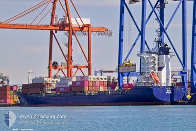
MITO
Cargo/Container Ship
Current Trip
IL HFA
| Time Travelled | --- |
|---|---|
| Remaining Time | --- |
| Distance Travelled | --- |
| Remaining Distance | --- |
| AVG Speed | --- |
| MAX Speed | --- |
| AVG Wind | --- |
| MAX Wind | --- |
| MIN Temp | --- |
| MAX Temp | --- |
| Draught | 8.6 m |
| Position Received | 2 m ago |
Current Position
| Longitude | 35.49084° |
|---|---|
| Latitude | 33.81820° |
| Status | Moored |
| Speed | |
| Course | 353° |
| Area | Mediterranean Sea - Eastern Basin |
| Station | T-AIS |
| Position Received | 2 m ago |
Info
Information
The current position of MITO is in Mediterranean Sea - Eastern Basin with coordinates 33.81820° / 35.49084° as reported on 2024-05-17 03:40 by AIS to our vessel tracker app. The vessel's current speed is 0 Knots
The vessel MITO (IMO: 9319571, MMSI: 255806508) is a Cargo/Container Ship that was built in 2006 ( 18 years old ). It's sailing under the flag of [PT] Portugal.
In this page you can find informations about the vessels current position, last detected port calls, and current voyage information. If the vessels is not in coverage by AIS you will find the latest position.
The current position of MITO is detected by our AIS receivers and we are not responsible for the reliability of the data. The last position was recorded while the vessel was in Coverage by the Ais receivers of our vessel tracking app.
The current draught of MITO as reported by AIS is 8.6 meters
Weather
| Temperature | 18.7°C / 65.66°F |
|---|---|
| Wind Speed | 2 knots |
| Direction | 272° W |
| Pressure | 1018.2 hPa |
| Humidity | 55.4 % |
| Cloud Coverage | --- |
Featured Company
Last Port Calls
| Port | Arrival | Departure | Time In Port |
|---|---|---|---|
| 2024-05-16 23:28 | |||
| 2024-05-14 05:40 | 2024-05-15 20:08 | 1 d | |
| 2024-05-07 09:11 | 2024-05-07 16:39 | 7 h | |
| 2024-05-06 04:46 | 2024-05-06 19:38 | 14 h | |
| 2024-05-04 20:16 | 2024-05-05 12:46 | 16 h | |
| 2024-04-29 22:38 | 2024-04-30 19:21 | 20 h | |
| 2024-04-28 12:48 | 2024-04-29 04:36 | 15 h | |
| 2024-04-22 22:17 | 2024-04-24 03:12 | 1 d | |
| 2024-04-17 06:36 | 2024-04-17 20:56 | 14 h | |
| 2024-04-12 14:18 | 2024-04-13 11:42 | 21 h |
Last Trips
| Origin | Departure | Destination | Arrival | Distance | |
|---|---|---|---|---|---|
| 2024-05-15 22:08 | 2024-05-17 02:28 | 303.90 nm | |||
| 2024-05-07 18:39 | 2024-05-14 07:40 | 1190.04 nm | |||
| 2024-05-06 21:38 | 2024-05-07 11:11 | 138.41 nm | |||
| 2024-05-05 14:46 | 2024-05-06 06:46 | 70.88 nm | |||
| 2024-04-30 21:21 | 2024-05-04 22:16 | 1289.29 nm | |||
| 2024-04-29 06:36 | 2024-04-30 00:38 | 130.48 nm | |||
| 2024-04-24 05:12 | 2024-04-28 14:48 | 1555.94 nm | |||
| 2024-04-17 23:56 | 2024-04-23 00:17 | 1783.20 nm | |||
| 2024-04-13 13:42 | 2024-04-17 09:36 | 485.11 nm | |||
| 2024-04-09 06:36 | 2024-04-12 16:18 | 1185.68 nm |
Events
| Time | Event | Details | Position / Dest | Info |
|---|---|---|---|---|
| 2024-05-17 02:40 | IN Coverage |
33.81820 / 35.49078
Mediterranean Sea - Eastern Basin
|
Speed: Course: 83.8° |
|
| 2024-05-17 01:02 | OUT of Coverage |
32.81542 / 35.01374
Mediterranean Sea - Eastern Basin
[IL] HAIFA
|
Speed: Course: 116.9° |
|
| 2024-05-16 23:28 | IN Coverage |
32.81554 / 35.01375
Mediterranean Sea - Eastern Basin
[IL] HAIFA
|
Speed: Course: 116.9° |
|
| 2024-05-16 23:28 | PORT ARRIVAL |
|
32.81554 / 35.01375
[IL] HAIFA
|
Speed: Course: 352° |
| 2024-05-16 21:50 | OUT of Coverage |
33.81824 / 35.49075
Mediterranean Sea - Eastern Basin
|
Speed: Course: 74.1° |
|
| 2024-05-16 16:29 | Status Changed | Moored Under way using engine |
33.81826 / 35.49078
IL HFA
|
Speed: Course: 352° |
| 2024-05-16 12:39 | IN Coverage |
33.81800 / 35.49135
Mediterranean Sea - Eastern Basin
IL HFA
|
Speed: Course: 200.4° |
|
| 2024-05-16 02:49 | Status Changed | Default Under way using engine |
32.10067 / 32.96513
IL HFA
|
Speed: 10.5 kn Course: 60.6° |
| 2024-05-16 02:43 | OUT of Coverage |
32.09312 / 32.94925
Mediterranean Sea - Eastern Basin
IL HFA
|
Speed: 10.5 kn Course: 60.6° |
|
| 2024-05-16 02:03 | Status Changed | Under way using engine Default |
32.03161 / 32.82754
IL HFA
|
Speed: 10.5 kn Course: 59° |