
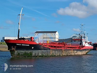
MNO ZEEZAND
Trailing Suction Hopper Dredger
Current Trip
DREDGE AREA
| Time Travelled | 8 h, 0 mins |
|---|---|
| Remaining Time | --- |
| Distance Travelled | 81.88 nm |
| Remaining Distance | --- |
| AVG Speed | 10.3 Knots |
| MAX Speed | 12.3 Knots |
| AVG Wind | 13.3 knots |
| MAX Wind | 16.9 knots |
| MIN Temp | 12.6°C / 54.68°F |
| MAX Temp | 13.5°C / 56.3°F |
| Draught | 5.1 m |
| Position Received | Now |
Current Position
| Longitude | 3.36271° |
|---|---|
| Latitude | 51.68557° |
| Status | Under way using engine |
| Speed | 9.5 Knots |
| Course | 155.9° |
| Area | North Sea |
| Station | T-AIS |
| Position Received | Now |
Info
Information
The current position of MNO ZEEZAND is in North Sea with coordinates 51.68557° / 3.36271° as reported on 2024-06-02 22:06 by AIS to our vessel tracker app. The vessel's current speed is 9.5 Knots
The vessel MNO ZEEZAND (IMO: 9196278, MMSI: 244430000) is a Trailing Suction Hopper Dredger that was built in 1999 ( 25 years old ). It's sailing under the flag of [NL] Netherlands.
In this page you can find informations about the vessels current position, last detected port calls, and current voyage information. If the vessels is not in coverage by AIS you will find the latest position.
The current position of MNO ZEEZAND is detected by our AIS receivers and we are not responsible for the reliability of the data. The last position was recorded while the vessel was in Coverage by the Ais receivers of our vessel tracking app.
The current draught of MNO ZEEZAND as reported by AIS is 5.1 meters
Weather
| Temperature | 12.8°C / 55.04°F |
|---|---|
| Wind Speed | 8 knots |
| Direction | 19° NNE |
| Pressure | 1024 hPa |
| Humidity | 78.8 % |
| Cloud Coverage | --- |
Featured Company
Last Port Calls
| Port | Arrival | Departure | Time In Port |
|---|---|---|---|
| 2024-06-02 12:06 | 2024-06-02 14:07 | 2 h | |
| 2024-06-02 07:38 | 2024-06-02 08:44 | 1 h | |
| 2024-06-02 03:44 | 2024-06-02 04:03 | 19 m | |
| 2024-06-01 23:42 | 2024-06-02 00:19 | 37 m | |
| 2024-06-01 18:35 | 2024-06-01 19:56 | 1 h | |
| 2024-06-01 11:34 | 2024-06-01 14:15 | 2 h | |
| 2024-05-31 23:00 | 2024-06-01 03:28 | 4 h | |
| 2024-05-30 21:14 | 2024-05-31 02:34 | 5 h | |
| 2024-05-30 13:54 | 2024-05-30 14:48 | 54 m | |
| 2024-05-29 20:45 | 2024-05-30 01:52 | 5 h |
Most Visited Ports (Last year)
| Port | Arrivals | |
|---|---|---|
| 742 | ||
| 145 | ||
| 8 |
Last Trips
| Origin | Departure | Destination | Arrival | Distance | |
|---|---|---|---|---|---|
| 2024-06-02 10:44 | 2024-06-02 14:06 | 23.80 nm | |||
| 2024-06-02 06:03 | 2024-06-02 09:38 | 24.84 nm | |||
| 2024-06-02 02:19 | 2024-06-02 05:44 | 26.92 nm | |||
| 2024-06-01 21:56 | 2024-06-02 01:42 | 26.96 nm | |||
| 2024-06-01 16:15 | 2024-06-01 20:35 | 28.70 nm | |||
| 2024-06-01 05:28 | 2024-06-01 13:34 | 67.95 nm | |||
| 2024-05-31 04:34 | 2024-06-01 01:00 | 144.15 nm | |||
| 2024-05-30 16:48 | 2024-05-30 23:14 | 55.82 nm | |||
| 2024-05-30 03:52 | 2024-05-30 15:54 | 56.34 nm | |||
| 2024-05-29 04:41 | 2024-05-29 22:45 | 95.65 nm |
Events
| Time | Event | Details | Position / Dest | Info |
|---|---|---|---|---|
| 2024-06-02 20:23 | Status Changed | Under way using engine Default |
51.95143 / 3.33385
DREDGE AREA
|
Speed: 10.4 kn Course: 194° |
| 2024-06-02 20:13 | Status Changed | Default Under way using engine |
51.98007 / 3.34639
DREDGE AREA
|
Speed: 10.3 kn Course: 191.7° |
| 2024-06-02 20:05 | Status Changed | Under way using engine Default |
52.00273 / 3.35476
DREDGE AREA
|
Speed: 10.7 kn Course: 197° |
| 2024-06-02 19:40 | Status Changed | Default Under way using engine |
52.07404 / 3.39087
DREDGE AREA
|
Speed: 7.1 kn Course: 205.1° |
| 2024-06-02 19:36 | Status Changed | Under way using engine Default |
52.08123 / 3.39510
DREDGE AREA
|
Speed: 7.4 kn Course: 207° |
| 2024-06-02 19:20 | IN Coverage |
52.08063 / 3.39472
North Sea
|
Speed: 7.1 kn Course: 205.1° |
|
| 2024-06-02 18:35 | Status Changed | Default Under way using engine |
52.11333 / 3.63833
DREDGE AREA
|
Speed: 10.8 kn Course: 284.7° |
| 2024-06-02 18:34 | OUT of Coverage |
52.11301 / 3.64412
North Sea
|
Speed: 10.8 kn Course: 284.7° |
|
| 2024-06-02 18:12 | Status Changed | Under way using engine Default |
52.12053 / 3.75278
DREDGE AREA
|
Speed: 11.9 kn Course: 182° |
| 2024-06-02 18:12 | IN Coverage |
52.11415 / 3.73185
North Sea
|
Speed: 12 kn Course: 251.2° |