
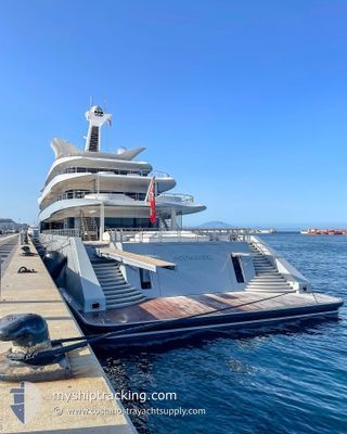
MOONRISE
Pleasure Craft
Current Trip
ILE ST MARGUERITE
| Time Travelled | 28 days |
|---|---|
| Remaining Time | --- |
| Distance Travelled | 826.64 nm |
| Remaining Distance | --- |
| AVG Speed | 13.6 Knots |
| MAX Speed | 17.2 Knots |
| AVG Wind | 10.2 knots |
| MAX Wind | 22.9 knots |
| MIN Temp | 18.2°C / 64.76°F |
| MAX Temp | 26.1°C / 78.98°F |
| Draught | 4.2 m |
| Position Received | 2 m ago |
Current Position
| Longitude | 7.05649° |
|---|---|
| Latitude | 43.53191° |
| Status | At anchor |
| Speed | |
| Course | 62° |
| Area | Mediterranean Sea - Western Basin |
| Station | T-AIS |
| Position Received | 2 m ago |
Info
Information
The current position of MOONRISE is in Mediterranean Sea - Western Basin with coordinates 43.53191° / 7.05649° as reported on 2024-06-25 23:42 by AIS to our vessel tracker app. The vessel's current speed is 0 Knots
The vessel MOONRISE (IMO: 9816232, MMSI: 319178500) is a Pleasure Craft It's sailing under the flag of [KY] Cayman Is.
In this page you can find informations about the vessels current position, last detected port calls, and current voyage information. If the vessels is not in coverage by AIS you will find the latest position.
The current position of MOONRISE is detected by our AIS receivers and we are not responsible for the reliability of the data. The last position was recorded while the vessel was in Coverage by the Ais receivers of our vessel tracking app.
The current draught of MOONRISE as reported by AIS is 4.2 meters
Weather
| Temperature | 19.6°C / 67.28°F |
|---|---|
| Wind Speed | 4 knots |
| Direction | 272° W |
| Pressure | 1012.6 hPa |
| Humidity | 84.9 % |
| Cloud Coverage | 95 % |
Featured Company
Last Port Calls
| Port | Arrival | Departure | Time In Port |
|---|---|---|---|
| 2024-04-29 13:36 | 2024-05-28 06:55 | 28 d | |
| 2024-04-26 06:21 | 2024-04-29 06:22 | 3 d | |
| 2024-04-15 16:31 | 2024-04-17 12:40 | 1 d |
Last Trips
| Origin | Departure | Destination | Arrival | Distance | |
|---|---|---|---|---|---|
| 2024-04-29 08:22 | 2024-04-29 15:36 | 94.21 nm | |||
| 2024-04-17 08:40 | 2024-04-26 08:21 | 3269.53 nm | |||
| 2024-03-25 09:12 | 2024-04-15 12:31 | 220.42 nm |
Events
| Time | Event | Details | Position / Dest | Info |
|---|---|---|---|---|
| 2024-06-24 11:23 | Draught Changed | 4.2 4 |
43.53227 / 7.05532
ILE ST MARGUERITE
|
Speed: Course: 101° |
| 2024-06-24 11:23 | ETA Changed | 2024/06/21 08:30 |
43.53227 / 7.05532
ILE ST MARGUERITE
|
Speed: Course: 101° |
| 2024-06-24 11:11 | Draught Changed | 4 4.2 |
43.53227 / 7.05531
ILE ST MARGUERITE
|
Speed: Course: 103° |
| 2024-06-21 18:56 | Status Changed | At anchor Under way using engine |
43.53258 / 7.05783
ILE ST MARGUERITE
|
Speed: Course: 268° |
| 2024-06-21 18:53 | Status Changed | Under way using engine At anchor |
43.53258 / 7.05783
ILE ST MARGUERITE
|
Speed: Course: 303° |
| 2024-06-21 07:53 | Status Changed | At anchor Under way using engine |
43.53202 / 7.05695
ILE ST MARGUERITE
|
Speed: 0.5 kn Course: 301° |
| 2024-06-21 07:50 | STOP Moving | 1.55 nm, South East of CANNES |
43.53186 / 7.05661
ILE ST MARGUERITE
|
Speed: 0.3 kn Course: 282° |
| 2024-06-21 07:27 | START Moving | 1.68 nm, South East of GOLFE JUAN |
43.54939 / 7.11116
ILE ST MARGUERITE
|
Speed: 4.1 kn Course: 194° |
| 2024-06-21 07:23 | Destination Changed | ILE ST MARGUERITE GOLFE JUAN |
43.55118 / 7.11027
ILE ST MARGUERITE
|
Speed: 0.6 kn Course: 46° |
| 2024-06-21 07:23 | ETA Changed | 2024/06/21 08:30 2024/06/15 15:00 |
43.55118 / 7.11027
ILE ST MARGUERITE
|
Speed: 0.6 kn Course: 46° |