
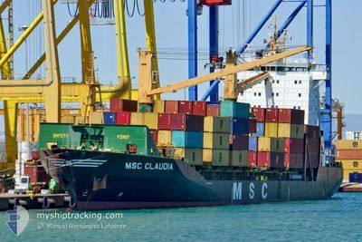
MSC CLAUDIA
Container Ship
Current Trip
| Time Travelled | 20 h, 54 mins |
|---|---|
| Remaining Time | --- |
| Distance Travelled | 141.94 nm |
| Remaining Distance | --- |
| AVG Speed | 21.1 Knots |
| MAX Speed | 21.1 Knots |
| AVG Wind | 4.5 knots |
| MAX Wind | 11 knots |
| MIN Temp | 18.8°C / 65.84°F |
| MAX Temp | 22.2°C / 71.96°F |
| Draught | 7.7 m |
| Position Received | 1 m ago |
Current Position
| Longitude | 35.48958° |
|---|---|
| Latitude | 33.81789° |
| Status | Under way using engine |
| Speed | 0.1 Knots |
| Course | --- |
| Area | Mediterranean Sea - Eastern Basin |
| Station | T-AIS |
| Position Received | 1 m ago |
Info
Information
The current position of MSC CLAUDIA is in Mediterranean Sea - Eastern Basin with coordinates 33.81789° / 35.48958° as reported on 2024-05-28 20:43 by AIS to our vessel tracker app. The vessel's current speed is 0.1 Knots and is heading at the port of HAIFA. The estimated time of arrival as calculated by vessel tracking app is 2024-05-26 09:50 LT
The vessel MSC CLAUDIA (IMO: 9113446, MMSI: 636018573) is a Container Ship that was built in 1996 ( 28 years old ). It's sailing under the flag of [LR] Liberia.
In this page you can find informations about the vessels current position, last detected port calls, and current voyage information. If the vessels is not in coverage by AIS you will find the latest position.
The current position of MSC CLAUDIA is detected by our AIS receivers and we are not responsible for the reliability of the data. The last position was recorded while the vessel was in Coverage by the Ais receivers of our vessel tracking app.
The current draught of MSC CLAUDIA as reported by AIS is 7.7 meters
Weather
| Temperature | 19°C / 66.2°F |
|---|---|
| Wind Speed | 4 knots |
| Direction | 227° SW |
| Pressure | 1014 hPa |
| Humidity | 81.6 % |
| Cloud Coverage | 4 % |
Featured Company
Last Port Calls
| Port | Arrival | Departure | Time In Port |
|---|---|---|---|
| 2024-05-27 22:39 | 2024-05-27 23:50 | 1 h | |
| 2024-05-27 22:20 | 2024-05-27 22:24 | 4 m | |
| 2024-05-27 20:53 | 2024-05-27 22:14 | 1 h | |
| 2024-05-27 09:13 | 2024-05-27 20:29 | 11 h | |
| 2024-05-27 06:55 | 2024-05-27 09:08 | 2 h | |
| 2024-05-24 20:52 | 2024-05-25 08:48 | 11 h | |
| 2024-05-23 10:45 | 2024-05-24 08:24 | 21 h | |
| 2024-05-21 23:22 | 2024-05-22 04:28 | 5 h | |
| 2024-05-21 17:25 | |||
| 2024-05-21 14:12 | 2024-05-21 17:15 | 3 h |
Last Trips
| Origin | Departure | Destination | Arrival | Distance | |
|---|---|---|---|---|---|
| 2024-05-28 01:24 | 2024-05-28 01:39 | 0.54 nm | |||
| 2024-05-28 01:14 | 2024-05-28 01:20 | 0.60 nm | |||
| 2024-05-27 23:29 | 2024-05-27 23:53 | 2.49 nm | |||
| 2024-05-27 12:08 | 2024-05-27 12:13 | 0.83 nm | |||
| 2024-05-25 11:48 | 2024-05-27 09:55 | 801.06 nm | |||
| 2024-05-24 11:24 | 2024-05-24 23:52 | 92.74 nm | |||
| 2024-05-22 07:28 | 2024-05-23 13:45 | 446.81 nm | |||
| 2024-05-21 20:15 | 2024-05-21 20:25 | 6.65 nm | |||
| 2024-05-21 20:15 | 2024-05-21 17:12 | 6.65 nm | |||
| 2024-05-21 07:37 | 2024-05-21 08:51 | 4.90 nm |
Events
| Time | Event | Details | Position / Dest | Info |
|---|---|---|---|---|
| 2024-05-28 20:04 | Status Changed | Under way using engine Moored |
33.81832 / 35.49077
ILHFA
|
Speed: Course: 511° |
| 2024-05-28 19:26 | ETA Changed | 2024/05/29 01:00 2024/05/29 09:50 |
33.81804 / 35.48839
ILHFA
|
Speed: 0.1 kn Course: 511° |
| 2024-05-28 19:24 | Draught Changed | 7.7 8.5 |
33.81804 / 35.48839
ILHFA
|
Speed: 0.1 kn Course: 511° |
| 2024-05-28 19:24 | ETA Changed | 2024/05/29 09:50 2024/05/26 09:50 |
33.81804 / 35.48839
ILHFA
|
Speed: 0.1 kn Course: 511° |
| 2024-05-28 16:00 | STOP Moving | 6.14 nm, South of BEIRUT |
33.81826 / 35.49074
ILHFA
|
Speed: Course: 351° |
| 2024-05-28 15:55 | START Moving | 6.66 nm, South of BEIRUT |
33.81001 / 35.48727
ILHFA
|
Speed: 86.5 kn Course: 207.6° |
| 2024-05-28 10:13 | Status Changed | Moored Default |
33.81831 / 35.49075
ILHFA
|
Speed: Course: -1° |
| 2024-05-28 10:10 | Status Changed | Default Moored |
33.81831 / 35.49076
ILHFA
|
Speed: Course: 511° |
| 2024-05-28 07:24 | Status Changed | Moored Under way using engine |
33.81829 / 35.49073
ILHFA
|
Speed: Course: 511° |
| 2024-05-28 07:05 | IN Coverage |
33.81817 / 35.49190
Mediterranean Sea - Eastern Basin
|
Speed: Course: 175.4° |