
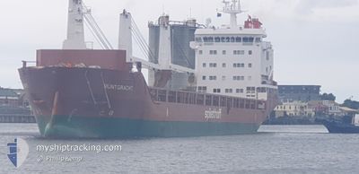
MUNTGRACHT
General Cargo
Current Trip
| Time Travelled | 1 day |
|---|---|
| Remaining Time | 7 h, 54 mins |
| Distance Travelled | 432.77 nm |
| Remaining Distance | 113.80 nm |
| AVG Speed | 12.1 Knots |
| MAX Speed | 15 Knots |
| AVG Wind | 10.4 knots |
| MAX Wind | 14.9 knots |
| MIN Temp | 17.4°C / 63.32°F |
| MAX Temp | 24.6°C / 76.28°F |
| Draught | 7.6 m |
| Position Received | 34 m ago |
Current Position
| Longitude | 8.11046° |
|---|---|
| Latitude | 42.56746° |
| Status | Under way using engine |
| Speed | 13.8 Knots |
| Course | 60.3° |
| Area | Mediterranean Sea - Western Basin |
| Station | T-AIS |
| Position Received | 34 m ago |
Info
Information
The current position of MUNTGRACHT is in Mediterranean Sea - Western Basin with coordinates 42.56746° / 8.11046° as reported on 2024-05-23 19:44 by AIS to our vessel tracker app. The vessel's current speed is 13.8 Knots and is heading at the port of LIVORNO. The estimated time of arrival as calculated by vessel tracking app is 2024-05-24 04:13 LT
The vessel MUNTGRACHT (IMO: 9571545, MMSI: 246771000) is a General Cargo that was built in 2012 ( 12 years old ). It's sailing under the flag of [NL] Netherlands.
In this page you can find informations about the vessels current position, last detected port calls, and current voyage information. If the vessels is not in coverage by AIS you will find the latest position.
The current position of MUNTGRACHT is detected by our AIS receivers and we are not responsible for the reliability of the data. The last position was recorded while the vessel was in Coverage by the Ais receivers of our vessel tracking app.
The current draught of MUNTGRACHT as reported by AIS is 7.6 meters
Weather
| Temperature | 17.8°C / 64.04°F |
|---|---|
| Wind Speed | 13 knots |
| Direction | 219° SW |
| Pressure | 1017.3 hPa |
| Humidity | 79.6 % |
| Cloud Coverage | --- |
Featured Company
Last Port Calls
| Port | Arrival | Departure | Time In Port |
|---|---|---|---|
| 2024-05-21 17:01 | 2024-05-22 11:30 | 18 h | |
| 2024-05-20 05:10 | 2024-05-20 21:54 | 16 h | |
| 2024-05-14 07:07 | 2024-05-15 06:20 | 23 h | |
| 2024-05-08 02:52 | 2024-05-08 17:20 | 14 h | |
| 2024-05-05 12:16 | 2024-05-07 13:32 | 2 d | |
| 2024-04-28 18:53 | 2024-04-30 16:04 | 1 d | |
| 2024-04-15 00:27 | 2024-04-19 01:39 | 4 d | |
| 2024-04-01 00:07 | 2024-04-02 20:33 | 1 d | |
| 2024-03-25 13:47 | 2024-03-28 04:33 | 2 d | |
| 2024-03-21 13:00 | 2024-03-23 11:46 | 1 d |
Most Visited Ports (Last year)
| Port | Arrivals | |
|---|---|---|
| 4 | ||
| 2 | ||
| 2 | ||
| 1 | ||
| 1 | ||
| 1 |
Last Trips
| Origin | Departure | Destination | Arrival | Distance | |
|---|---|---|---|---|---|
| 2024-05-20 23:54 | 2024-05-21 19:01 | 255.36 nm | |||
| 2024-05-15 07:20 | 2024-05-20 07:10 | 1385.53 nm | |||
| 2024-05-08 20:20 | 2024-05-14 08:07 | 1506.07 nm | |||
| 2024-05-07 15:32 | 2024-05-08 05:52 | 142.35 nm | |||
| 2024-04-30 18:04 | 2024-05-05 14:16 | 1263.25 nm | |||
| 2024-04-18 21:39 | 2024-04-28 20:53 | 2928.74 nm | |||
| 2024-04-02 22:33 | 2024-04-14 20:27 | 3159.92 nm | |||
| 2024-03-28 04:33 | 2024-04-01 02:07 | 348.15 nm | |||
| 2024-03-23 12:46 | 2024-03-25 13:47 | 344.12 nm | |||
| 2024-03-14 19:19 | 2024-03-21 14:00 | 994.45 nm |
Events
| Time | Event | Details | Position / Dest | Info |
|---|---|---|---|---|
| 2024-05-23 17:58 | Status Changed | Under way using engine Default |
42.36850 / 7.64037
ITLIV
|
Speed: 13 kn Course: 60° |
| 2024-05-23 17:35 | Status Changed | Default Under way using engine |
42.32167 / 7.53333
ITLIV
|
Speed: 13.6 kn Course: 59.6° |
| 2024-05-23 17:22 | Status Changed | Under way using engine Default |
42.29806 / 7.47683
ITLIV
|
Speed: 13 kn Course: 59° |
| 2024-05-23 17:22 | IN Coverage |
42.29806 / 7.47683
Mediterranean Sea - Western Basin
ITLIV
|
Speed: 13.5 kn Course: 59° |
|
| 2024-05-23 12:17 | Status Changed | Default Under way using engine |
41.72666 / 6.13667
ITLIV
|
Speed: 13.9 kn Course: 61.2° |
| 2024-05-23 12:12 | Change Sea Area | French part of the Mediterranean Sea - Western Basin Spanish part of the Balearic Sea |
41.71842 / 6.11675
Mediterranean Sea - Western Basin
ITLIV
|
Speed: 13.9 kn Course: 61.2° |
| 2024-05-23 12:12 | Status Changed | Under way using engine Default |
41.71842 / 6.11675
ITLIV
|
Speed: 13 kn Course: 60° |
| 2024-05-23 12:12 | OUT of Coverage |
41.71842 / 6.11675
Mediterranean Sea - Western Basin
ITLIV
|
Speed: 13.9 kn Course: 61.2° |
|
| 2024-05-23 11:55 | IN Coverage |
41.71842 / 6.11675
Mediterranean Sea - Western Basin
ITLIV
|
Speed: 13.9 kn Course: 61.2° |
|
| 2024-05-22 13:38 | OUT of Coverage |
39.16053 / .27984
Balearic Sea
ITLIV
|
Speed: 13.6 kn Course: 71.8° |