
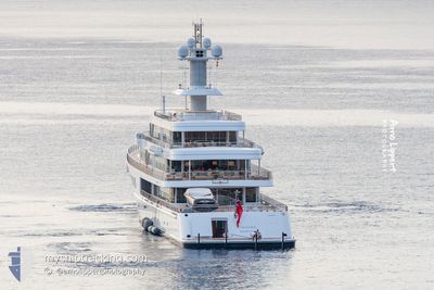
MUSASHI
Yacht
Current Trip
NERANO
| Time Travelled | 2 days |
|---|---|
| Remaining Time | --- |
| Distance Travelled | 439.04 nm |
| Remaining Distance | --- |
| AVG Speed | 12.8 Knots |
| MAX Speed | 16.9 Knots |
| AVG Wind | 8.2 knots |
| MAX Wind | 16 knots |
| MIN Temp | 18.6°C / 65.48°F |
| MAX Temp | 27.1°C / 80.78°F |
| Draught | 4.2 m |
| Position Received | 1 m ago |
Current Position
| Longitude | 14.34230° |
|---|---|
| Latitude | 40.55353° |
| Status | Under way using engine |
| Speed | 9.5 Knots |
| Course | 45.3° |
| Area | Tyrrhenian Sea |
| Station | T-AIS |
| Position Received | 1 m ago |
Info
Information
The current position of MUSASHI is in Tyrrhenian Sea with coordinates 40.55353° / 14.34230° as reported on 2024-06-20 14:56 by AIS to our vessel tracker app. The vessel's current speed is 9.5 Knots
The vessel MUSASHI (IMO: 1010131, MMSI: 319032600) is a Yacht that was built in 2011 ( 13 years old ). It's sailing under the flag of [KY] Cayman Is.
In this page you can find informations about the vessels current position, last detected port calls, and current voyage information. If the vessels is not in coverage by AIS you will find the latest position.
The current position of MUSASHI is detected by our AIS receivers and we are not responsible for the reliability of the data. The last position was recorded while the vessel was in Coverage by the Ais receivers of our vessel tracking app.
The current draught of MUSASHI as reported by AIS is 4.2 meters
Weather
| Temperature | 26.7°C / 80.06°F |
|---|---|
| Wind Speed | 9 knots |
| Direction | 295° WNW |
| Pressure | 1016 hPa |
| Humidity | 61.7 % |
| Cloud Coverage | 1 % |
Featured Company
Events
| Time | Event | Details | Position / Dest | Info |
|---|---|---|---|---|
| 2024-06-20 14:37 | ETA Changed | 2024/06/20 17:20 2024/06/20 18:00 |
40.53453 / 14.27813
NERANO
|
Speed: 10.2 kn Course: 80.1° |
| 2024-06-20 14:26 | ETA Changed | 2024/06/20 18:00 2024/06/19 22:00 |
40.53279 / 14.24030
NERANO
|
Speed: 9.9 kn Course: 100° |
| 2024-06-20 14:21 | START Moving | 1.53 nm, South West of CAPRI |
40.53473 / 14.22542
NERANO
|
Speed: 3.1 kn Course: 96° |
| 2024-06-20 14:20 | Destination Changed | NERANO CAPRI |
40.53481 / 14.22421
NERANO
|
Speed: 2 kn Course: 105° |
| 2024-06-20 14:16 | Status Changed | Under way using engine At anchor |
40.53533 / 14.22286
CAPRI
|
Speed: 0.2 kn Course: 238° |
| 2024-06-19 21:00 | Status Changed | At anchor Under way using engine |
40.53274 / 14.22330
CAPRI
|
Speed: Course: 41° |
| 2024-06-19 20:48 | STOP Moving | 1.72 nm, South West of CAPRI |
40.53232 / 14.22241
CAPRI
|
Speed: 0.3 kn Course: 59° |
| 2024-06-19 14:02 | Destination Changed | CAPRI 0STIA |
41.61869 / 12.37041
CAPRI
|
Speed: 16.1 kn Course: 136.9° |
| 2024-06-19 14:02 | ETA Changed | 2024/06/19 22:00 2024/06/19 08:00 |
41.61869 / 12.37041
CAPRI
|
Speed: 16.1 kn Course: 136.9° |
| 2024-06-19 13:43 | START Moving | 4 nm, South East of PORTO TURISTICO DI ROMA |
41.68129 / 12.29341
0STIA
|
Speed: 15.8 kn Course: 138.2° |