
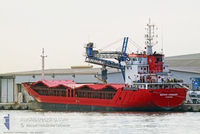
MUSTAFA HARMANDA
General Cargo
Current Trip
| Time Travelled | 2 days |
|---|---|
| Remaining Time | --- |
| Distance Travelled | 312.98 nm |
| Remaining Distance | --- |
| AVG Speed | 8.6 Knots |
| MAX Speed | 10.5 Knots |
| AVG Wind | 8.3 knots |
| MAX Wind | 12 knots |
| MIN Temp | 14.8°C / 58.64°F |
| MAX Temp | 25.2°C / 77.36°F |
| Draught | 6.2 m |
| Position Received | Now |
Current Position
| Longitude | 29.01167° |
|---|---|
| Latitude | 41.28930° |
| Status | At anchor |
| Speed | 0.2 Knots |
| Course | 297° |
| Area | Black Sea |
| Station | T-AIS |
| Position Received | Now |
Info
Information
The current position of MUSTAFA HARMANDA is in Black Sea with coordinates 41.28930° / 29.01167° as reported on 2024-05-23 08:12 by AIS to our vessel tracker app. The vessel's current speed is 0.2 Knots and is heading at the port of ALEXANDRIA. The estimated time of arrival as calculated by vessel tracking app is 2024-05-26 08:00 LT
The vessel MUSTAFA HARMANDA (IMO: 9280225, MMSI: 371020000) is a General Cargo that was built in 2003 ( 21 years old ). It's sailing under the flag of [PA] Panama.
In this page you can find informations about the vessels current position, last detected port calls, and current voyage information. If the vessels is not in coverage by AIS you will find the latest position.
The current position of MUSTAFA HARMANDA is detected by our AIS receivers and we are not responsible for the reliability of the data. The last position was recorded while the vessel was in Coverage by the Ais receivers of our vessel tracking app.
The current draught of MUSTAFA HARMANDA as reported by AIS is 6.2 meters
Weather
| Temperature | 17.4°C / 63.32°F |
|---|---|
| Wind Speed | 6 knots |
| Direction | 15° NNE |
| Pressure | 1010.4 hPa |
| Humidity | 72.6 % |
| Cloud Coverage | 2 % |
Featured Company
Last Port Calls
| Port | Arrival | Departure | Time In Port |
|---|---|---|---|
| 2024-05-21 05:50 | |||
| 2024-05-16 12:00 | 2024-05-17 03:36 | 15 h | |
| 2024-05-10 15:01 | 2024-05-13 10:02 | 2 d | |
| 2024-05-06 04:24 | 2024-05-07 07:10 | 1 d | |
| 2024-05-01 19:45 | 2024-05-04 11:20 | 2 d | |
| 2024-04-18 13:09 | 2024-04-24 08:32 | 5 d | |
| 2024-04-15 21:50 | 2024-04-17 06:27 | 1 d | |
| 2024-04-04 14:30 | 2024-04-05 20:03 | 1 d | |
| 2024-03-28 06:56 | 2024-04-01 18:05 | 4 d | |
| 2024-03-24 04:01 | 2024-03-25 05:25 | 1 d |
Last Trips
| Origin | Departure | Destination | Arrival | Distance | |
|---|---|---|---|---|---|
| 2024-05-13 13:02 | 2024-05-16 15:00 | 548.30 nm | |||
| 2024-05-07 09:10 | 2024-05-10 18:01 | 675.57 nm | |||
| 2024-05-04 13:20 | 2024-05-06 06:24 | 41.60 nm | |||
| 2024-04-24 10:32 | 2024-05-01 21:45 | 578.66 nm | |||
| 2024-04-17 08:27 | 2024-04-18 15:09 | 190.02 nm | |||
| 2024-04-05 23:03 | 2024-04-15 23:50 | 1414.43 nm | |||
| 2024-04-01 21:05 | 2024-04-04 17:30 | 667.75 nm | |||
| 2024-03-25 08:25 | 2024-03-28 08:56 | 413.39 nm | |||
| 2024-03-21 18:34 | 2024-03-24 07:01 | 399.64 nm | |||
| 2024-03-13 12:36 | 2024-03-16 14:57 | 661.03 nm |
Events
| Time | Event | Details | Position / Dest | Info |
|---|---|---|---|---|
| 2024-05-22 19:15 | STOP Moving | 5.8 nm, North West of RUMELI FENERI |
41.28966 / 29.01084
EGALY
|
Speed: 0.3 kn Course: 331° |
| 2024-05-22 19:09 | Status Changed | At anchor Under way using engine |
41.28876 / 29.01082
EGALY
|
Speed: 3.7 kn Course: 264° |
| 2024-05-22 18:06 | Draught Changed | 6.2 4.2 |
41.40311 / 29.12567
EGALY
|
Speed: 8.5 kn Course: 206.1° |
| 2024-05-22 18:06 | Destination Changed | EGALY RO GAL |
41.40311 / 29.12567
EGALY
|
Speed: 8.5 kn Course: 206.1° |
| 2024-05-22 18:06 | ETA Changed | 2024/05/26 08:00 2024/05/16 19:00 |
41.40311 / 29.12567
EGALY
|
Speed: 8.5 kn Course: 206.1° |
| 2024-05-22 17:22 | Status Changed | Under way using engine Default |
41.49929 / 29.17626
RO GAL
|
Speed: 8.6 kn Course: 201° |
| 2024-05-22 17:15 | IN Coverage |
41.49792 / 29.17546
Black Sea
|
Speed: 8.6 kn Course: 203.7° |
|
| 2024-05-21 17:37 | START Moving | 10.24 nm, East of SFANTU GHEORGHE |
44.89432 / 29.82985
RO GAL
|
Speed: 7 kn Course: 176° |
| 2024-05-21 17:20 | STOP Moving | 10.26 nm, East of SFANTU GHEORGHE |
44.89904 / 29.83021
RO GAL
|
Speed: 0.2 kn Course: 149° |
| 2024-05-21 05:50 | PORT DEPARTURE |
|
45.44681 / 28.18798
RO GAL
|
Speed: Course: 183° |