
MUTARE
Dredging or underwater ops
Current Trip
| Trip Time | 15 h, 30 mins |
|---|---|
| Trip Distance | 18.47 nm |
| AVG Speed | 6.2 Knots |
| MAX Speed | 8.9 Knots |
| Draught | 2 m |
| AVG Wind | 7.3 knots |
| MAX Wind | 12.8 knots |
| MIN Temp | 13.7°C / 56.66°F |
| MAX Temp | 15°C / 59°F |
| Position Received | 56 m ago |
Current Position
| Longitude | 5.27342° |
|---|---|
| Latitude | 52.68825° |
| Status | Moored |
| Speed | 0.1 Knots |
| Course | --- |
| Area | North Sea |
| Station | T-AIS |
| Position Received | 56 m ago |
Info
Information
The current position of MUTARE is in North Sea with coordinates 52.68825° / 5.27342° as reported on 2024-06-04 08:37 by AIS to our vessel tracker app. The vessel's current speed is 0.1 Knots and is currently inside the port of BOVENKARSPEL.
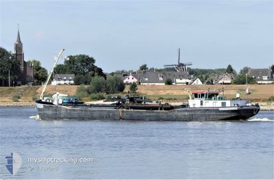
The vessel MUTARE (MMSI: 244740762) is a Dredging or underwater ops It's sailing under the flag of [NL] Netherlands.
In this page you can find informations about the vessels current position, last detected port calls, and current voyage information. If the vessels is not in coverage by AIS you will find the latest position.
The current position of MUTARE is detected by our AIS receivers and we are not responsible for the reliability of the data. The last position was recorded while the vessel was in Coverage by the Ais receivers of our vessel tracking app.
The current draught of MUTARE as reported by AIS is 2 meters
Weather
| Temperature | 14.5°C / 58.1°F |
|---|---|
| Wind Speed | 12 knots |
| Direction | 198° SSW |
| Pressure | 1013.3 hPa |
| Humidity | 86.9 % |
| Cloud Coverage | 100 % |
Featured Company
Last Port Calls
| Port | Arrival | Departure | Time In Port |
|---|---|---|---|
| 2024-06-04 08:37 | |||
| 2024-06-03 16:46 | 2024-06-03 17:07 | 20 m | |
| 2024-06-03 15:10 | 2024-06-03 15:41 | 31 m | |
| 2024-06-03 07:23 | 2024-06-03 09:06 | 1 h | |
| 2024-05-30 18:33 | 2024-05-31 12:53 | 18 h | |
| 2024-05-29 17:27 | 2024-05-29 17:52 | 25 m | |
| 2024-05-29 15:40 | 2024-05-29 16:07 | 27 m | |
| 2024-05-29 02:47 | 2024-05-29 03:19 | 31 m | |
| 2024-05-28 11:50 | 2024-05-28 12:06 | 15 m | |
| 2024-05-27 08:43 | 2024-05-27 09:48 | 1 h |
Last Trips
| Origin | Departure | Destination | Arrival | Distance | |
|---|---|---|---|---|---|
| 2024-06-03 19:07 | 2024-06-04 10:37 | 18.47 nm | |||
| 2024-06-03 17:41 | 2024-06-03 18:46 | 10.79 nm | |||
| 2024-06-03 11:06 | 2024-06-03 17:10 | 20.29 nm | |||
| 2024-05-31 14:53 | 2024-06-03 09:23 | 22.04 nm | |||
| 2024-05-29 19:52 | 2024-05-30 20:33 | 10.80 nm | |||
| 2024-05-29 18:07 | 2024-05-29 19:27 | 10.68 nm | |||
| 2024-05-29 05:19 | 2024-05-29 17:40 | 20.05 nm | |||
| 2024-05-28 14:06 | 2024-05-29 04:47 | 61.23 nm | |||
| 2024-05-27 11:48 | 2024-05-28 13:50 | 68.03 nm | |||
| 2024-05-26 23:11 | 2024-05-27 10:43 | 29.61 nm |
Events
| Time | Event | Details | Position / Dest | Info |
|---|---|---|---|---|
| 2024-06-04 08:37 | IN Coverage |
52.68825 / 5.27342
North Sea
[NL] BOVENKARSPEL
|
Speed: 0.1 kn Course: 511° |
|
| 2024-06-04 08:37 | PORT ARRIVAL |
|
52.68825 / 5.27342
[NL] BOVENKARSPEL
|
Speed: 2.2 kn Course: 511° |
| 2024-06-03 22:16 | OUT of Coverage |
52.78121 / 5.27635
North Sea
|
Speed: 2.2 kn Course: 192.6° |
|
| 2024-06-03 21:11 | START Moving | 2.64 nm, East of OUDE ZEUG |
52.85937 / 5.18346
SCHAGEN
|
Speed: 3.8 kn Course: 125.4° |
| 2024-06-03 21:07 | Status Changed | Under way using engine Moored |
52.86069 / 5.18108
SCHAGEN
|
Speed: 0.2 kn Course: 511° |
| 2024-06-03 18:10 | Status Changed | Moored Under way using engine |
52.86078 / 5.18162
SCHAGEN
|
Speed: 0.2 kn Course: 511° |
| 2024-06-03 17:55 | STOP Moving | 2.57 nm, East of OUDE ZEUG |
52.86073 / 5.18137
SCHAGEN
|
Speed: 0.3 kn Course: 511° |
| 2024-06-03 17:08 | START Moving | 0.36 nm, North of MARINA DEN OEVER |
52.92947 / 5.04871
SCHAGEN
|
Speed: 7.3 kn Course: 141.8° |
| 2024-06-03 17:07 | PORT DEPARTURE |
|
52.93014 / 5.04773
SCHAGEN
|
Speed: 5.1 kn Course: 141.3° |
| 2024-06-03 16:56 | STOP Moving |
52.93101 / 5.04656
[NL] DEN OEVER
|
Speed: 0.3 kn Course: 511° |