
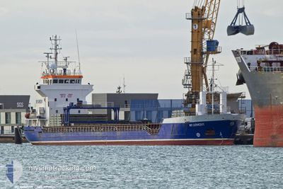
MY ARMONY
General Cargo
Current Trip
| Time Travelled | 14 h, 10 mins |
|---|---|
| Remaining Time | 10 h, 56 mins |
| Distance Travelled | 138.20 nm |
| Remaining Distance | 112.12 nm |
| AVG Speed | 10 Knots |
| MAX Speed | 10.6 Knots |
| AVG Wind | 5.3 knots |
| MAX Wind | 8.8 knots |
| MIN Temp | 19.9°C / 67.82°F |
| MAX Temp | 21.7°C / 71.06°F |
| Draught | 3.8 m |
| Position Received | 23 m ago |
Current Position
| Longitude | 7.21873° |
|---|---|
| Latitude | 43.03363° |
| Status | Under way using engine |
| Speed | 10.4 Knots |
| Course | 220.6° |
| Area | Mediterranean Sea - Western Basin |
| Station | T-AIS |
| Position Received | 23 m ago |
Info
Information
The current position of MY ARMONY is in Mediterranean Sea - Western Basin with coordinates 43.03363° / 7.21873° as reported on 2024-06-26 05:45 by AIS to our vessel tracker app. The vessel's current speed is 10.4 Knots and is heading at the port of FOS. The estimated time of arrival as calculated by vessel tracking app is 2024-06-26 17:04 LT
The vessel MY ARMONY (IMO: 9190365, MMSI: 314490000) is a General Cargo that was built in 1999 ( 25 years old ). It's sailing under the flag of [BB] Barbados.
In this page you can find informations about the vessels current position, last detected port calls, and current voyage information. If the vessels is not in coverage by AIS you will find the latest position.
The current position of MY ARMONY is detected by our AIS receivers and we are not responsible for the reliability of the data. The last position was recorded while the vessel was in Coverage by the Ais receivers of our vessel tracking app.
The current draught of MY ARMONY as reported by AIS is 3.8 meters
Weather
| Temperature | 20.7°C / 69.26°F |
|---|---|
| Wind Speed | 5 knots |
| Direction | 311° NW |
| Pressure | 1011.8 hPa |
| Humidity | 85 % |
| Cloud Coverage | 90 % |
Featured Company
Last Port Calls
| Port | Arrival | Departure | Time In Port |
|---|---|---|---|
| 2024-06-20 09:03 | 2024-06-25 15:58 | 5 d | |
| 2024-06-16 07:18 | 2024-06-16 13:54 | 6 h | |
| 2024-06-13 20:38 | |||
| 2024-06-01 22:26 | 2024-06-06 11:24 | 4 d | |
| 2024-05-24 09:15 | 2024-05-26 01:00 | 1 d | |
| 2024-05-16 12:12 | 2024-05-18 12:13 | 2 d | |
| 2024-05-08 22:30 | 2024-05-09 21:37 | 23 h | |
| 2024-05-06 14:16 | 2024-05-07 22:11 | 1 d | |
| 2024-05-02 12:13 | 2024-05-06 09:43 | 3 d | |
| 2024-04-27 20:56 | 2024-04-29 21:20 | 2 d |
Most Visited Ports (Last year)
| Port | Arrivals | |
|---|---|---|
| 3 | ||
| 2 | ||
| 2 | ||
| 2 | ||
| 2 | ||
| 2 |
Last Trips
| Origin | Departure | Destination | Arrival | Distance | |
|---|---|---|---|---|---|
| 2024-06-16 15:54 | 2024-06-20 11:03 | 874.67 nm | |||
| 2024-06-13 21:38 | 2024-06-16 09:18 | 528.36 nm | |||
| 2024-05-26 02:00 | 2024-06-01 23:26 | 1370.78 nm | |||
| 2024-05-18 14:13 | 2024-05-24 10:15 | 698.79 nm | |||
| 2024-05-10 00:37 | 2024-05-16 14:12 | 1488.69 nm | |||
| 2024-05-08 01:11 | 2024-05-09 01:30 | 87.47 nm | |||
| 2024-05-06 12:43 | 2024-05-06 17:16 | 8.72 nm | |||
| 2024-04-30 00:20 | 2024-05-02 15:13 | 623.60 nm | |||
| 2024-04-18 20:55 | 2024-04-27 23:56 | 2125.78 nm | |||
| 2024-04-13 11:25 | 2024-04-16 15:06 | 617.13 nm |
Events
| Time | Event | Details | Position / Dest | Info |
|---|---|---|---|---|
| 2024-06-26 05:45 | Status Changed | Default Under way using engine |
43.03254 / 7.21743
FRFOS
|
Speed: 10.4 kn Course: 220.6° |
| 2024-06-26 03:44 | Detected in Sea | French part of the Mediterranean Sea - Western Basin |
43.13703 / 7.64535
Mediterranean Sea - Western Basin
FRFOS
|
Speed: 9.8 kn Course: 257.1° |
| 2024-06-26 03:35 | Detected in Sea | Mon�gasque part of the Mediterranean Sea - Western Basin |
43.14236 / 7.67791
Mediterranean Sea - Western Basin
FRFOS
|
Speed: 9.6 kn Course: 257° |
| 2024-06-26 02:56 | Change Sea Area | French part of the Mediterranean Sea - Western Basin Italian part of the Mediterranean Sea - Western Basin |
43.16515 / 7.81905
Mediterranean Sea - Western Basin
FRFOS
|
Speed: 9.6 kn Course: 257.6° |
| 2024-06-25 23:53 | Detected in Sea | Italian part of the Mediterranean Sea - Western Basin |
43.28096 / 8.48999
Mediterranean Sea - Western Basin
FRFOS
|
Speed: 10.5 kn Course: 257.6° |
| 2024-06-25 23:05 | Detected in Sea | French part of the Mediterranean Sea - Western Basin |
43.30831 / 8.67695
Mediterranean Sea - Western Basin
FRFOS
|
Speed: 10.3 kn Course: 258.6° |
| 2024-06-25 21:28 | Detected in Sea | French part of the Ligurian Sea |
43.37357 / 9.04537
Ligurian Sea
FRFOS
|
Speed: 10 kn Course: 257.9° |
| 2024-06-25 21:28 | Status Changed | Under way using engine Default |
43.37395 / 9.04773
FRFOS
|
Speed: 9.9 kn Course: 258° |
| 2024-06-25 21:28 | IN Coverage |
43.37357 / 9.04537
Ligurian Sea
FRFOS
|
Speed: 10 kn Course: 257.9° |
|
| 2024-06-25 20:05 | OUT of Coverage |
43.42351 / 9.35238
Ligurian Sea
FRFOS
|
Speed: 9.9 kn Course: 257.1° |