
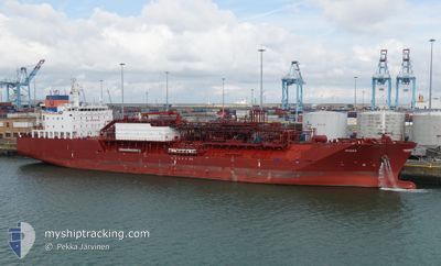
MYGAS
Tanker
Current Trip
OPL MALTA
| Time Travelled | 3 days |
|---|---|
| Remaining Time | --- |
| Distance Travelled | 384.52 nm |
| Remaining Distance | --- |
| AVG Speed | 11.5 Knots |
| MAX Speed | 13.4 Knots |
| AVG Wind | 13.3 knots |
| MAX Wind | 24.9 knots |
| MIN Temp | 19.5°C / 67.1°F |
| MAX Temp | 28.1°C / 82.58°F |
| Draught | 6.2 m |
| Position Received | 16 h, 9 m ago |
Current Position
| Longitude | 14.90848° |
|---|---|
| Latitude | 35.85178° |
| Status | At anchor |
| Speed | |
| Course | 334° |
| Area | Mediterranean Sea - Eastern Basin |
| Station | T-AIS |
| Position Received | 16 h, 9 m ago |
Info
Information
The current position of MYGAS is in Mediterranean Sea - Eastern Basin with coordinates 35.85178° / 14.90848° as reported on 2024-05-27 07:11 by AIS to our vessel tracker app. The vessel's current speed is 0 Knots
The vessel MYGAS (IMO: 9694397, MMSI: 305377000) is a Tanker It's sailing under the flag of [AG] Antigua Barbuda.
In this page you can find informations about the vessels current position, last detected port calls, and current voyage information. If the vessels is not in coverage by AIS you will find the latest position.
The current position of MYGAS is detected by our AIS receivers and we are not responsible for the reliability of the data. The last position was recorded while the vessel was in Coverage by the Ais receivers of our vessel tracking app.
The current draught of MYGAS as reported by AIS is 6.2 meters
Weather
| Temperature | 20.7°C / 69.26°F |
|---|---|
| Wind Speed | 5 knots |
| Direction | 178° S |
| Pressure | 1017.7 hPa |
| Humidity | 71.1 % |
| Cloud Coverage | 35 % |
Featured Company
Last Port Calls
| Port | Arrival | Departure | Time In Port |
|---|---|---|---|
| 2024-05-23 06:08 | 2024-05-24 14:26 | 1 d | |
| 2024-05-15 06:43 | 2024-05-16 05:05 | 22 h | |
| 2024-05-10 19:24 | 2024-05-12 01:22 | 1 d | |
| 2024-04-20 21:59 | 2024-04-21 18:59 | 20 h | |
| 2024-04-14 20:34 | 2024-04-15 09:33 | 12 h | |
| 2024-03-01 15:30 | 2024-03-07 04:35 | 5 d |
Last Trips
| Origin | Departure | Destination | Arrival | Distance | |
|---|---|---|---|---|---|
| 2024-05-16 07:05 | 2024-05-23 08:08 | 1195.02 nm | |||
| 2024-05-12 02:22 | 2024-05-15 08:43 | 815.35 nm | |||
| 2024-04-21 13:59 | 2024-05-10 20:24 | 4679.11 nm | |||
| 2024-04-15 04:33 | 2024-04-20 16:59 | 78.42 nm | |||
| 2024-03-06 22:35 | 2024-04-14 15:34 | 3690.61 nm | |||
| 2024-02-28 01:28 | 2024-03-01 09:30 | 34.72 nm |
Events
| Time | Event | Details | Position / Dest | Info |
|---|---|---|---|---|
| 2024-05-27 07:17 | Status Changed | Default At anchor |
35.85179 / 14.90852
OPL MALTA
|
Speed: Course: 334° |
| 2024-05-27 07:11 | Status Changed | At anchor Default |
35.85178 / 14.90848
OPL MALTA
|
Speed: Course: 336° |
| 2024-05-27 07:11 | OUT of Coverage |
35.85178 / 14.90848
Mediterranean Sea - Eastern Basin
|
Speed: Course: 189.7° |
|
| 2024-05-27 06:59 | Status Changed | Default At anchor |
35.85182 / 14.90842
OPL MALTA
|
Speed: Course: 331° |
| 2024-05-27 06:38 | Status Changed | At anchor Default |
35.85177 / 14.90848
OPL MALTA
|
Speed: Course: -1° |
| 2024-05-27 06:38 | IN Coverage |
35.85177 / 14.90848
Mediterranean Sea - Eastern Basin
|
Speed: Course: 189.7° |
|
| 2024-05-27 05:44 | Status Changed | Default At anchor |
35.85166 / 14.90833
OPL MALTA
|
Speed: 0.1 kn Course: 325° |
| 2024-05-27 05:29 | OUT of Coverage |
35.85173 / 14.90891
Mediterranean Sea - Eastern Basin
|
Speed: 0.1 kn Course: 189.7° |
|
| 2024-05-27 05:20 | Status Changed | At anchor Default |
35.85184 / 14.90916
OPL MALTA
|
Speed: Course: -1° |
| 2024-05-27 05:05 | IN Coverage |
35.85184 / 14.90916
Mediterranean Sea - Eastern Basin
|
Speed: Course: 189.7° |