
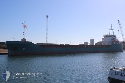
NAOMI-B
General Cargo
Current Trip
| Time Travelled | 1 day |
|---|---|
| Remaining Time | 4 days |
| Distance Travelled | 265.89 nm |
| Remaining Distance | 1029.67 nm |
| AVG Speed | 7.8 Knots |
| MAX Speed | 10.2 Knots |
| AVG Wind | 13.6 knots |
| MAX Wind | 23.8 knots |
| MIN Temp | 14.1°C / 57.38°F |
| MAX Temp | 15.9°C / 60.62°F |
| Draught | 2.9 m |
| Position Received | Now |
Current Position
| Longitude | -3.83931° |
|---|---|
| Latitude | 49.32279° |
| Status | Under way using engine |
| Speed | 10.1 Knots |
| Course | 57.1° |
| Area | English Channel |
| Station | T-AIS |
| Position Received | Now |
Info
Information
The current position of NAOMI-B is in English Channel with coordinates 49.32279° / -3.83931° as reported on 2024-06-17 13:01 by AIS to our vessel tracker app. The vessel's current speed is 10.1 Knots and is heading at the port of ROSTOCK. The estimated time of arrival as calculated by vessel tracking app is 2024-06-21 20:25 LT
The vessel NAOMI-B (IMO: 9557367, MMSI: 210383000) is a General Cargo that was built in 2013 ( 11 years old ). It's sailing under the flag of [CY] Cyprus.
In this page you can find informations about the vessels current position, last detected port calls, and current voyage information. If the vessels is not in coverage by AIS you will find the latest position.
The current position of NAOMI-B is detected by our AIS receivers and we are not responsible for the reliability of the data. The last position was recorded while the vessel was in Coverage by the Ais receivers of our vessel tracking app.
The current draught of NAOMI-B as reported by AIS is 2.9 meters
Weather
| Temperature | 14.9°C / 58.82°F |
|---|---|
| Wind Speed | 9 knots |
| Direction | 78° ENE |
| Pressure | 1010.9 hPa |
| Humidity | 82.4 % |
| Cloud Coverage | 100 % |
Featured Company
Last Port Calls
| Port | Arrival | Departure | Time In Port |
|---|---|---|---|
| 2024-06-13 19:16 | 2024-06-15 15:11 | 1 d | |
| 2024-06-02 13:50 | 2024-06-06 16:40 | 4 d | |
| 2024-05-31 04:55 | 2024-05-31 21:18 | 16 h | |
| 2024-05-31 03:08 | 2024-05-31 03:18 | 10 m | |
| 2024-05-26 06:55 | 2024-05-27 19:47 | 1 d | |
| 2024-05-22 15:32 | 2024-05-24 14:33 | 1 d | |
| 2024-05-16 17:37 | 2024-05-18 13:21 | 1 d | |
| 2024-05-16 16:10 | 2024-05-16 16:41 | 31 m | |
| 2024-05-08 11:42 | 2024-05-10 13:07 | 2 d | |
| 2024-05-05 07:52 | 2024-05-07 09:57 | 2 d |
Last Trips
| Origin | Departure | Destination | Arrival | Distance | |
|---|---|---|---|---|---|
| 2024-06-06 18:40 | 2024-06-13 21:16 | 792.06 nm | |||
| 2024-05-31 22:18 | 2024-06-02 15:50 | 332.60 nm | |||
| 2024-05-31 04:18 | 2024-05-31 05:55 | 10.47 nm | |||
| 2024-05-27 21:47 | 2024-05-31 04:08 | 581.09 nm | |||
| 2024-05-24 16:33 | 2024-05-26 08:55 | 208.71 nm | |||
| 2024-05-18 15:21 | 2024-05-22 17:32 | 771.87 nm | |||
| 2024-05-16 18:41 | 2024-05-16 19:37 | 9.24 nm | |||
| 2024-05-10 14:07 | 2024-05-16 18:10 | 176.99 nm | |||
| 2024-05-07 11:57 | 2024-05-08 12:42 | 83.98 nm | |||
| 2024-05-02 18:03 | 2024-05-05 09:52 | 148.83 nm |
Events
| Time | Event | Details | Position / Dest | Info |
|---|---|---|---|---|
| 2024-06-17 08:28 | Change Sea Area | French part of the English Channel French part of the Celtic Sea |
48.87201 / -4.75721
English Channel
ROSTOK
|
Speed: 9.2 kn Course: 58.2° |
| 2024-06-17 06:56 | Status Changed | Under way using engine Default |
48.73311 / -5.03747
ROSTOK
|
Speed: 9 kn Course: 51° |
| 2024-06-17 06:30 | Status Changed | Default Under way using engine |
48.69584 / -5.11244
ROSTOK
|
Speed: 8.8 kn Course: 51.4° |
| 2024-06-17 05:54 | Status Changed | Under way using engine Default |
48.64138 / -5.21451
ROSTOK
|
Speed: 8.7 kn Course: 42° |
| 2024-06-17 05:45 | Status Changed | Default Under way using engine |
48.62521 / -5.23832
ROSTOK
|
Speed: 8.5 kn Course: 45.4° |
| 2024-06-17 05:39 | Status Changed | Under way using engine Default |
48.61470 / -5.25320
ROSTOK
|
Speed: 8.7 kn Course: 47° |
| 2024-06-17 05:30 | Status Changed | Default Under way using engine |
48.59857 / -5.27571
ROSTOK
|
Speed: 8.7 kn Course: 57.6° |
| 2024-06-17 04:59 | Status Changed | Under way using engine Default |
48.54218 / -5.34972
ROSTOK
|
Speed: 8.9 kn Course: 51° |
| 2024-06-17 04:59 | IN Coverage |
48.54218 / -5.34972
Celtic Sea
ROSTOK
|
Speed: 8.5 kn Course: 30.4° |
|
| 2024-06-17 03:44 | OUT of Coverage |
48.37732 / -5.44094
Celtic Sea
ROSTOK
|
Speed: 8.9 kn Course: 0.1° |