
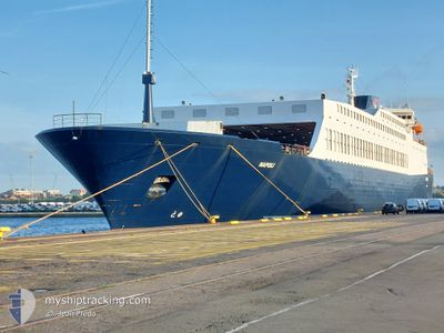
NAPOLI
Ro-Ro/Passenger Ship
Current Trip
| Time Travelled | 9 h, 51 mins |
|---|---|
| Remaining Time | --- |
| Distance Travelled | 17.19 nm |
| Remaining Distance | --- |
| AVG Speed | 10.8 Knots |
| MAX Speed | 13.8 Knots |
| AVG Wind | 21 knots |
| MAX Wind | 30.8 knots |
| MIN Temp | 18.7°C / 65.66°F |
| MAX Temp | 19.6°C / 67.28°F |
| Draught | 5.4 m |
| Position Received | 8 h, 14 m ago |
Current Position
| Longitude | 5.98719° |
|---|---|
| Latitude | 42.84173° |
| Status | Under way using engine |
| Speed | 11.8 Knots |
| Course | 180.5° |
| Area | Mediterranean Sea - Western Basin |
| Station | T-AIS |
| Position Received | 8 h, 14 m ago |
Info
Information
The current position of NAPOLI is in Mediterranean Sea - Western Basin with coordinates 42.84173° / 5.98719° as reported on 2024-05-31 21:07 by AIS to our vessel tracker app. The vessel's current speed is 11.8 Knots and is heading at the port of DJEN DJEN. The estimated time of arrival as calculated by vessel tracking app is 2024-06-02 07:00 LT
The vessel NAPOLI (IMO: 9108568, MMSI: 352001535) is a Ro-Ro/Passenger Ship that was built in 1995 ( 29 years old ). It's sailing under the flag of [PA] Panama.
In this page you can find informations about the vessels current position, last detected port calls, and current voyage information. If the vessels is not in coverage by AIS you will find the latest position.
The current position of NAPOLI is detected by our AIS receivers and we are not responsible for the reliability of the data. The last position was recorded while the vessel was in Coverage by the Ais receivers of our vessel tracking app.
The current draught of NAPOLI as reported by AIS is 5.4 meters
Weather
| Temperature | 18.6°C / 65.48°F |
|---|---|
| Wind Speed | 31 knots |
| Direction | 309° NW |
| Pressure | 1008.9 hPa |
| Humidity | 63 % |
| Cloud Coverage | --- |
Featured Company
Last Port Calls
| Port | Arrival | Departure | Time In Port |
|---|---|---|---|
| 2024-05-31 08:16 | 2024-05-31 19:31 | 11 h | |
| 2024-05-30 08:02 | 2024-05-31 02:18 | 18 h | |
| 2024-05-29 06:53 | 2024-05-29 10:06 | 3 h | |
| 2024-05-28 07:05 | 2024-05-28 09:50 | 2 h | |
| 2024-05-27 04:01 | 2024-05-27 18:47 | 14 h | |
| 2024-05-24 09:27 | 2024-05-24 19:47 | 10 h | |
| 2024-05-21 04:35 | 2024-05-22 09:24 | 1 d | |
| 2024-05-18 10:26 | 2024-05-18 18:54 | 8 h | |
| 2024-05-15 05:02 | 2024-05-16 05:33 | 1 d | |
| 2024-05-11 16:20 | 2024-05-11 22:00 | 5 h |
Most Visited Ports (Last year)
| Port | Arrivals | |
|---|---|---|
| 17 | ||
| 17 | ||
| 13 | ||
| 10 | ||
| 8 | ||
| 6 |
Last Trips
| Origin | Departure | Destination | Arrival | Distance | |
|---|---|---|---|---|---|
| 2024-05-31 04:18 | 2024-05-31 10:16 | 70.93 nm | |||
| 2024-05-29 12:06 | 2024-05-30 10:02 | 249.99 nm | |||
| 2024-05-28 11:50 | 2024-05-29 08:53 | 153.34 nm | |||
| 2024-05-27 20:47 | 2024-05-28 09:05 | 160.86 nm | |||
| 2024-05-24 21:47 | 2024-05-27 06:01 | 335.82 nm | |||
| 2024-05-22 11:24 | 2024-05-24 11:27 | 399.29 nm | |||
| 2024-05-18 20:54 | 2024-05-21 06:35 | 674.32 nm | |||
| 2024-05-16 07:33 | 2024-05-18 12:26 | 494.83 nm | |||
| 2024-05-11 23:00 | 2024-05-15 07:02 | 977.13 nm | |||
| 2024-05-10 13:22 | 2024-05-11 17:20 | 378.69 nm |
Events
| Time | Event | Details | Position / Dest | Info |
|---|---|---|---|---|
| 2024-05-31 21:07 | OUT of Coverage |
42.84173 / 5.98719
Mediterranean Sea - Western Basin
DJEN DJEN
|
Speed: 11.8 kn Course: 180.5° |
|
| 2024-05-31 19:35 | START Moving | 0.56 nm, East of LA SEYNE-SUR-MER |
43.10663 / 5.90405
DJEN DJEN
|
Speed: 4.3 kn Course: 102° |
| 2024-05-31 19:32 | STOP Moving | 0.48 nm, East of LA SEYNE-SUR-MER |
43.10751 / 5.90188
DJEN DJEN
|
Speed: 0.2 kn Course: 149° |
| 2024-05-31 19:31 | PORT DEPARTURE |
|
43.10718 / 5.90175
DJEN DJEN
|
Speed: 2.3 kn Course: 197° |
| 2024-05-31 19:24 | START Moving |
43.10719 / 5.89344
[FR] LA SEYNE-SUR-MER
|
Speed: 3.1 kn Course: 278° |
|
| 2024-05-31 19:21 | Status Changed | Under way using engine Moored |
43.10760 / 5.89085
[FR] LA SEYNE-SUR-MER
|
Speed: 0.5 kn Course: 280° |
| 2024-05-31 15:48 | ETA Changed | 2024/06/02 07:00 2024/06/02 05:00 |
43.10801 / 5.89025
[FR] LA SEYNE-SUR-MER
|
Speed: Course: 279° |
| 2024-05-31 15:44 | Destination Changed | DJEN DJEN TOULON |
43.10805 / 5.89024
[FR] LA SEYNE-SUR-MER
|
Speed: Course: 279° |
| 2024-05-31 15:44 | ETA Changed | 2024/06/02 05:00 2024/05/31 08:00 |
43.10805 / 5.89024
[FR] LA SEYNE-SUR-MER
|
Speed: Course: 279° |
| 2024-05-31 08:40 | Status Changed | Moored Under way using engine |
43.10801 / 5.89026
[FR] LA SEYNE-SUR-MER
|
Speed: 0.2 kn Course: 278° |