
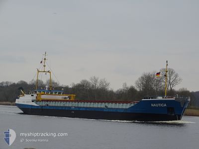
NAUTICA
General Cargo
Current Trip
ESRIB
| Time Travelled | 8 days |
|---|---|
| Remaining Time | --- |
| Distance Travelled | 675.97 nm |
| Remaining Distance | --- |
| AVG Speed | 8.7 Knots |
| MAX Speed | 11.2 Knots |
| AVG Wind | 11.3 knots |
| MAX Wind | 22 knots |
| MIN Temp | 13.4°C / 56.12°F |
| MAX Temp | 16.1°C / 60.98°F |
| Draught | 2.5 m |
| Position Received | 2 d ago |
Current Position
| Longitude | -7.03984° |
|---|---|
| Latitude | 43.53070° |
| Status | Moored |
| Speed | |
| Course | 38° |
| Area | Bay of Biscay |
| Station | T-AIS |
| Position Received | 2 d ago |
Info
Information
The current position of NAUTICA is in Bay of Biscay with coordinates 43.53070° / -7.03984° as reported on 2024-06-23 20:00 by AIS to our vessel tracker app. The vessel's current speed is 0 Knots
The vessel NAUTICA (IMO: 9032458, MMSI: 275506000) is a General Cargo that was built in 1992 ( 32 years old ). It's sailing under the flag of [LV] Latvia.
In this page you can find informations about the vessels current position, last detected port calls, and current voyage information. If the vessels is not in coverage by AIS you will find the latest position.
The current position of NAUTICA is detected by our AIS receivers and we are not responsible for the reliability of the data. The last position was recorded while the vessel was in Coverage by the Ais receivers of our vessel tracking app.
The current draught of NAUTICA as reported by AIS is 2.5 meters
Weather
| Temperature | 16.9°C / 62.42°F |
|---|---|
| Wind Speed | 14 knots |
| Direction | 21° NNE |
| Pressure | 1011.8 hPa |
| Humidity | 91.6 % |
| Cloud Coverage | 100 % |
Featured Company
Last Port Calls
| Port | Arrival | Departure | Time In Port |
|---|---|---|---|
| 2024-06-14 18:36 | 2024-06-17 19:01 | 3 d | |
| 2024-05-30 06:30 | 2024-05-31 19:19 | 1 d | |
| 2024-05-25 16:57 | 2024-05-28 10:08 | 2 d | |
| 2024-05-23 12:22 | 2024-05-24 00:32 | 12 h | |
| 2024-05-04 12:27 | 2024-05-08 12:51 | 4 d | |
| 2024-04-28 12:59 | 2024-04-30 10:49 | 1 d | |
| 2024-04-17 01:14 | 2024-04-17 13:47 | 12 h | |
| 2024-04-13 09:19 | 2024-04-15 17:33 | 2 d | |
| 2024-04-07 04:27 | 2024-04-11 18:36 | 4 d |
Last Trips
| Origin | Departure | Destination | Arrival | Distance | |
|---|---|---|---|---|---|
| 2024-05-31 21:19 | 2024-06-14 20:36 | 160.32 nm | |||
| 2024-05-28 12:08 | 2024-05-30 08:30 | 337.01 nm | |||
| 2024-05-24 02:32 | 2024-05-25 18:57 | 284.57 nm | |||
| 2024-05-08 14:51 | 2024-05-23 14:22 | 206.78 nm | |||
| 2024-04-30 12:49 | 2024-05-04 14:27 | 795.60 nm | |||
| 2024-04-17 14:47 | 2024-04-28 14:59 | 774.53 nm | |||
| 2024-04-15 18:33 | 2024-04-17 02:14 | 235.25 nm | |||
| 2024-04-11 20:36 | 2024-04-13 10:19 | 322.41 nm | |||
| 2024-03-25 17:04 | 2024-04-07 06:27 | 422.96 nm |
Events
| Time | Event | Details | Position / Dest | Info |
|---|---|---|---|---|
| 2024-06-25 18:04 | START Moving | 0.33 nm, North West of CASTROPOL |
43.53279 / -7.03692
ESRIB
|
Speed: 4.3 kn Course: 40° |
| 2024-06-23 20:15 | Status Changed | Default Moored |
43.53070 / -7.03985
ESRIB
|
Speed: Course: 38° |
| 2024-06-23 20:00 | Detected in Sea | Spanish part of the Bay of Biscay |
43.53070 / -7.03984
Bay of Biscay
|
Speed: Course: 169.8° |
| 2024-06-23 20:00 | Status Changed | Moored Default |
43.53070 / -7.03984
ESRIB
|
Speed: Course: 38° |
| 2024-06-23 20:00 | IN Coverage |
43.53070 / -7.03984
Bay of Biscay
|
Speed: Course: 169.8° |
|
| 2024-06-23 20:00 | OUT of Coverage |
43.53070 / -7.03984
Bay of Biscay
|
Speed: Course: 169.8° |
|
| 2024-06-19 22:34 | Status Changed | Default Under way using engine |
48.70819 / -5.95527
ESRIB
|
Speed: 8.3 kn Course: 206.1° |
| 2024-06-19 22:27 | OUT of Coverage |
48.72180 / -5.94459
Celtic Sea
ESRIB
|
Speed: 8.3 kn Course: 206.1° |
|
| 2024-06-19 22:27 | Status Changed | Under way using engine Default |
48.72249 / -5.94408
ESRIB
|
Speed: 8.3 kn Course: 210° |
| 2024-06-19 21:47 | Status Changed | Default Under way using engine |
48.80490 / -5.87345
ESRIB
|
Speed: 8.7 kn Course: 210.4° |