
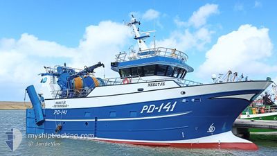
NEELTJE
Fishing
Current Trip
| Trip Time | 18 h, 2 mins |
|---|---|
| Trip Distance | 132.37 nm |
| AVG Speed | 8.3 Knots |
| MAX Speed | 12.1 Knots |
| Draught | 5 m |
| AVG Wind | 6.2 knots |
| MAX Wind | 11 knots |
| MIN Temp | 13.1°C / 55.58°F |
| MAX Temp | 14.5°C / 58.1°F |
| Position Received | Now |
Current Position
| Longitude | 3.59099° |
|---|---|
| Latitude | 51.44493° |
| Status | Engaged in Fishing |
| Speed | |
| Course | 193° |
| Area | North Sea |
| Station | T-AIS |
| Position Received | Now |
Info
Information
The current position of NEELTJE is in North Sea with coordinates 51.44493° / 3.59099° as reported on 2024-05-20 05:56 by AIS to our vessel tracker app. The vessel's current speed is 0 Knots and is currently inside the port of VLISSINGEN STATION.
The vessel NEELTJE (IMO: 9863522, MMSI: 232024332) is a Fishing It's sailing under the flag of [GB] United Kingdom.
In this page you can find informations about the vessels current position, last detected port calls, and current voyage information. If the vessels is not in coverage by AIS you will find the latest position.
The current position of NEELTJE is detected by our AIS receivers and we are not responsible for the reliability of the data. The last position was recorded while the vessel was in Coverage by the Ais receivers of our vessel tracking app.
The current draught of NEELTJE as reported by AIS is 5 meters
Weather
| Temperature | 13.2°C / 55.76°F |
|---|---|
| Wind Speed | 11 knots |
| Direction | 24° NNE |
| Pressure | 1012.2 hPa |
| Humidity | 90.2 % |
| Cloud Coverage | 63 % |
Featured Company
Last Port Calls
| Port | Arrival | Departure | Time In Port |
|---|---|---|---|
| 2024-05-17 18:01 | |||
| 2024-05-16 22:11 | 2024-05-16 23:59 | 1 h | |
| 2024-04-26 01:39 | 2024-05-12 23:28 | 16 d | |
| 2024-04-18 23:13 | 2024-04-22 00:29 | 3 d | |
| 2024-04-11 20:20 | 2024-04-15 00:34 | 3 d | |
| 2024-04-05 20:25 | 2024-04-08 00:31 | 2 d | |
| 2024-03-28 21:37 | 2024-04-01 19:03 | 3 d | |
| 2024-03-22 00:12 | 2024-03-25 01:32 | 3 d | |
| 2024-03-14 22:06 | 2024-03-18 01:35 | 3 d | |
| 2024-03-07 22:06 | 2024-03-11 01:32 | 3 d |
Most Visited Ports (Last year)
| Port | Arrivals | |
|---|---|---|
| 41 | ||
| 17 | ||
| 6 | ||
| 1 |
Last Trips
| Origin | Departure | Destination | Arrival | Distance | |
|---|---|---|---|---|---|
| 2024-05-17 01:59 | 2024-05-17 20:01 | 132.37 nm | |||
| 2024-05-13 01:28 | 2024-05-17 00:11 | 516.71 nm | |||
| 2024-04-22 02:29 | 2024-04-26 03:39 | 457.34 nm | |||
| 2024-04-15 02:34 | 2024-04-19 01:13 | 422.46 nm | |||
| 2024-04-08 02:31 | 2024-04-11 22:20 | 404.35 nm | |||
| 2024-04-01 21:03 | 2024-04-05 22:25 | 391.01 nm | |||
| 2024-03-25 02:32 | 2024-03-28 22:37 | 468.26 nm | |||
| 2024-03-18 02:35 | 2024-03-22 01:12 | 477.74 nm | |||
| 2024-03-11 02:32 | 2024-03-14 23:06 | 458.43 nm | |||
| 2024-03-04 02:36 | 2024-03-07 23:06 | 415.08 nm |
Events
| Time | Event | Details | Position / Dest | Info |
|---|---|---|---|---|
| 2024-05-17 18:01 | STOP Moving |
51.44422 / 3.59124
[NL] VLISSINGEN STATION
|
Speed: 0.1 kn Course: 165° |
|
| 2024-05-17 18:01 | PORT ARRIVAL |
|
51.44422 / 3.59124
[NL] VLISSINGEN STATION
|
Speed: 1 kn Course: 185° |
| 2024-05-17 17:59 | START Moving | 0.25 nm, South of VLISSINGEN STATION |
51.44359 / 3.59284
CH 16 FOR INFO
|
Speed: 4.8 kn Course: 307° |
| 2024-05-17 17:43 | STOP Moving | 0.35 nm, South East of VLISSINGEN STATION |
51.44264 / 3.59591
CH 16 FOR INFO
|
Speed: 0.3 kn Course: 297° |
| 2024-05-17 16:45 | Detected in Sea | Dutch part of the North Sea |
51.41472 / 3.32712
North Sea
|
Speed: 10.2 kn Course: 84° |
| 2024-05-17 12:34 | Change Sea Area | Belgian part of the North Sea French part of the North Sea |
51.50962 / 2.26885
North Sea
|
Speed: 10.3 kn Course: 98° |
| 2024-05-17 12:23 | IN Coverage |
51.52410 / 2.22733
North Sea
|
Speed: 7.3 kn Course: 104° |
|
| 2024-05-17 11:14 | OUT of Coverage |
51.51157 / 2.22397
North Sea
|
Speed: 2.6 kn Course: 93° |
|
| 2024-05-17 11:02 | Detected in Sea | French part of the North Sea |
51.49622 / 2.19882
North Sea
|
Speed: 11.1 kn Course: 3° |
| 2024-05-17 08:49 | Change Sea Area | United Kingdom part of the North Sea French part of the North Sea |
51.53802 / 2.19464
North Sea
|
Speed: 8.9 kn Course: 256° |