
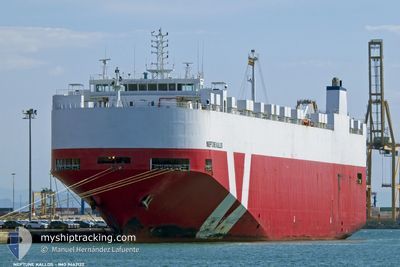
NEPTUNE KALLOS
Vehicles Carrier
Current Trip
| Time Travelled | 1 day |
|---|---|
| Remaining Time | 8 h, 47 mins |
| Distance Travelled | 343.66 nm |
| Remaining Distance | 190.65 nm |
| AVG Speed | 14.7 Knots |
| MAX Speed | 15.4 Knots |
| AVG Wind | 13.2 knots |
| MAX Wind | 28 knots |
| MIN Temp | 19.6°C / 67.28°F |
| MAX Temp | 22.2°C / 71.96°F |
| Draught | 8.4 m |
| Position Received | 3 h, 36 m ago |
Current Position
| Longitude | 29.88953° |
|---|---|
| Latitude | 35.77435° |
| Status | Under way using engine |
| Speed | 14.7 Knots |
| Course | 115° |
| Area | Mediterranean Sea - Eastern Basin |
| Station | T-AIS |
| Position Received | 3 h, 36 m ago |
Info
Information
The current position of NEPTUNE KALLOS is in Mediterranean Sea - Eastern Basin with coordinates 35.77435° / 29.88953° as reported on 2024-05-23 19:29 by AIS to our vessel tracker app. The vessel's current speed is 14.7 Knots and is heading at the port of LIMASSOL. The estimated time of arrival as calculated by vessel tracking app is 2024-05-24 07:52 LT
The vessel NEPTUNE KALLOS (IMO: 9442122, MMSI: 256010000) is a Vehicles Carrier that was built in 2010 ( 14 years old ). It's sailing under the flag of [MT] Malta.
In this page you can find informations about the vessels current position, last detected port calls, and current voyage information. If the vessels is not in coverage by AIS you will find the latest position.
The current position of NEPTUNE KALLOS is detected by our AIS receivers and we are not responsible for the reliability of the data. The last position was recorded while the vessel was in Coverage by the Ais receivers of our vessel tracking app.
The current draught of NEPTUNE KALLOS as reported by AIS is 8.4 meters
Weather
| Temperature | 21.9°C / 71.42°F |
|---|---|
| Wind Speed | 28 knots |
| Direction | 278° W |
| Pressure | 1007.5 hPa |
| Humidity | 75 % |
| Cloud Coverage | --- |
Featured Company
Last Port Calls
| Port | Arrival | Departure | Time In Port |
|---|---|---|---|
| 2024-05-22 09:55 | 2024-05-22 20:08 | 10 h | |
| 2024-05-20 18:59 | 2024-05-21 07:10 | 12 h | |
| 2024-05-20 06:42 | 2024-05-20 18:07 | 11 h | |
| 2024-05-19 11:52 | 2024-05-20 05:27 | 17 h | |
| 2024-05-14 14:21 | 2024-05-16 06:18 | 1 d | |
| 2024-05-09 15:27 | 2024-05-10 02:40 | 11 h | |
| 2024-05-08 21:54 | 2024-05-09 13:08 | 15 h | |
| 2024-05-07 08:20 | 2024-05-07 18:01 | 9 h | |
| 2024-05-05 20:55 | 2024-05-06 18:20 | 21 h | |
| 2024-05-04 09:09 | 2024-05-04 16:45 | 7 h |
Last Trips
| Origin | Departure | Destination | Arrival | Distance | |
|---|---|---|---|---|---|
| 2024-05-21 10:10 | 2024-05-22 12:55 | 395.58 nm | |||
| 2024-05-20 21:07 | 2024-05-20 21:59 | 4.68 nm | |||
| 2024-05-20 08:27 | 2024-05-20 09:42 | 13.19 nm | |||
| 2024-05-16 08:18 | 2024-05-19 14:52 | 1206.60 nm | |||
| 2024-05-10 04:40 | 2024-05-14 16:21 | 1682.41 nm | |||
| 2024-05-09 14:08 | 2024-05-09 17:27 | 20.94 nm | |||
| 2024-05-07 20:01 | 2024-05-08 22:54 | 413.51 nm | |||
| 2024-05-06 20:20 | 2024-05-07 10:20 | 164.46 nm | |||
| 2024-05-04 18:45 | 2024-05-05 22:55 | 80.23 nm | |||
| 2024-05-03 18:48 | 2024-05-04 11:09 | 205.93 nm |
Events
| Time | Event | Details | Position / Dest | Info |
|---|---|---|---|---|
| 2024-05-23 19:29 | OUT of Coverage |
35.77435 / 29.88953
Mediterranean Sea - Eastern Basin
CYLMS
|
Speed: 14.7 kn Course: 115° |
|
| 2024-05-23 19:16 | Change Sea Area | Turkish part of the Mediterranean Sea - Eastern Basin Greek part of the Mediterranean Sea - Eastern Basin |
35.79735 / 29.83217
Mediterranean Sea - Eastern Basin
CYLMS
|
Speed: 14.7 kn Course: 115° |
| 2024-05-23 18:39 | Status Changed | Under way using engine Default |
35.86622 / 29.66445
CYLMS
|
Speed: 14.9 kn Course: 116° |
| 2024-05-23 18:35 | Status Changed | Default Under way using engine |
35.87402 / 29.64557
CYLMS
|
Speed: 14.9 kn Course: 117° |
| 2024-05-23 17:34 | Detected in Sea | Greek part of the Mediterranean Sea - Eastern Basin |
35.99402 / 29.37327
Mediterranean Sea - Eastern Basin
CYLMS
|
Speed: 15 kn Course: 119° |
| 2024-05-23 17:34 | Status Changed | Under way using engine Default |
35.99402 / 29.37327
CYLMS
|
Speed: 14.4 kn Course: 118° |
| 2024-05-23 17:08 | Status Changed | Default Under way using engine |
36.04662 / 29.25772
CYLMS
|
Speed: 14.6 kn Course: 119° |
| 2024-05-23 14:44 | Change Sea Area | Turkish part of the Mediterranean Sea - Eastern Basin Greek part of the Mediterranean Sea - Eastern Basin |
36.32163 / 28.61967
Mediterranean Sea - Eastern Basin
CYLMS
|
Speed: 14.6 kn Course: 119° |
| 2024-05-23 13:17 | Change Sea Area | Greek part of the Mediterranean Sea - Eastern Basin Greek part of the Aegean Sea |
36.48478 / 28.22140
Mediterranean Sea - Eastern Basin
CYLMS
|
Speed: 15.2 kn Course: 90° |
| 2024-05-23 12:41 | Detected in Sea | Greek part of the Aegean Sea |
36.48342 / 28.03553
Aegean Sea
CYLMS
|
Speed: 14.9 kn Course: 88° |