
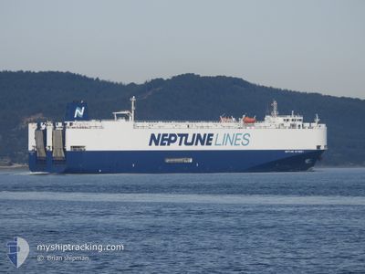
NEPTUNE ODYSSEY
Vehicles Carrier
Current Trip
| Time Travelled | 2 days |
|---|---|
| Remaining Time | 1 day |
| Distance Travelled | 941.50 nm |
| Remaining Distance | 458.32 nm |
| AVG Speed | 14.4 Knots |
| MAX Speed | 16.7 Knots |
| AVG Wind | 7.8 knots |
| MAX Wind | 22.9 knots |
| MIN Temp | 20.3°C / 68.54°F |
| MAX Temp | 36.8°C / 98.24°F |
| Draught | 8.5 m |
| Position Received | 1 m ago |
Current Position
| Longitude | 13.52195° |
|---|---|
| Latitude | 39.48997° |
| Status | Under way using engine |
| Speed | 15.1 Knots |
| Course | 301° |
| Area | Tyrrhenian Sea |
| Station | T-AIS |
| Position Received | 1 m ago |
Info
Information
The current position of NEPTUNE ODYSSEY is in Tyrrhenian Sea with coordinates 39.48997° / 13.52195° as reported on 2024-06-15 18:37 by AIS to our vessel tracker app. The vessel's current speed is 15.1 Knots and is heading at the port of MARSEILLE. The estimated time of arrival as calculated by vessel tracking app is 2024-06-17 00:33 LT
The vessel NEPTUNE ODYSSEY (IMO: 9440095, MMSI: 248406000) is a Vehicles Carrier that was built in 2010 ( 14 years old ). It's sailing under the flag of [MT] Malta.
In this page you can find informations about the vessels current position, last detected port calls, and current voyage information. If the vessels is not in coverage by AIS you will find the latest position.
The current position of NEPTUNE ODYSSEY is detected by our AIS receivers and we are not responsible for the reliability of the data. The last position was recorded while the vessel was in Coverage by the Ais receivers of our vessel tracking app.
The current draught of NEPTUNE ODYSSEY as reported by AIS is 8.5 meters
Weather
| Temperature | 22.6°C / 72.68°F |
|---|---|
| Wind Speed | 7 knots |
| Direction | 141° SE |
| Pressure | 1013 hPa |
| Humidity | 60.5 % |
| Cloud Coverage | 58 % |
Featured Company
Last Port Calls
| Port | Arrival | Departure | Time In Port |
|---|---|---|---|
| 2024-06-11 22:35 | 2024-06-13 01:08 | 1 d | |
| 2024-06-10 23:38 | 2024-06-11 17:15 | 17 h | |
| 2024-06-07 14:46 | 2024-06-08 22:22 | 1 d | |
| 2024-06-05 18:38 | 2024-06-06 03:14 | 8 h | |
| 2024-06-03 04:43 | 2024-06-03 09:14 | 4 h | |
| 2024-05-31 04:50 | 2024-05-31 16:55 | 12 h | |
| 2024-05-23 09:28 | 2024-05-24 16:24 | 1 d | |
| 2024-05-22 03:00 | 2024-05-22 10:29 | 7 h | |
| 2024-05-20 15:08 | 2024-05-20 21:51 | 6 h | |
| 2024-05-19 07:35 | 2024-05-20 10:30 | 1 d |
Last Trips
| Origin | Departure | Destination | Arrival | Distance | |
|---|---|---|---|---|---|
| 2024-06-11 20:15 | 2024-06-12 01:35 | 70.58 nm | |||
| 2024-06-09 01:22 | 2024-06-11 02:38 | 248.39 nm | |||
| 2024-06-06 06:14 | 2024-06-07 17:46 | 256.37 nm | |||
| 2024-06-03 12:14 | 2024-06-05 21:38 | 899.05 nm | |||
| 2024-05-31 19:55 | 2024-06-03 07:43 | 1043.36 nm | |||
| 2024-05-24 18:24 | 2024-05-31 07:50 | 1106.97 nm | |||
| 2024-05-22 12:29 | 2024-05-23 11:28 | 346.30 nm | |||
| 2024-05-20 23:51 | 2024-05-22 05:00 | 361.33 nm | |||
| 2024-05-20 11:30 | 2024-05-20 17:08 | 74.24 nm | |||
| 2024-05-18 20:57 | 2024-05-19 08:35 | 186.48 nm |
Events
| Time | Event | Details | Position / Dest | Info |
|---|---|---|---|---|
| 2024-06-15 16:39 | Status Changed | Under way using engine Default |
39.23580 / 14.06687
FRMRS
|
Speed: 15.2 kn Course: 301° |
| 2024-06-15 16:37 | Status Changed | Default Under way using engine |
39.23138 / 14.07626
FRMRS
|
Speed: 15.2 kn Course: 300.6° |
| 2024-06-15 13:55 | Status Changed | Under way using engine Default |
38.86979 / 14.83250
FRMRS
|
Speed: 15.2 kn Course: 301° |
| 2024-06-15 13:53 | Status Changed | Default Under way using engine |
38.86597 / 14.84042
FRMRS
|
Speed: 15.2 kn Course: 301.7° |
| 2024-06-15 10:13 | Status Changed | Under way using engine Default |
38.27835 / 15.70918
FRMRS
|
Speed: 11.3 kn Course: 60° |
| 2024-06-15 10:09 | Status Changed | Default Under way using engine |
38.27115 / 15.69799
FRMRS
|
Speed: 14.4 kn Course: 59.3° |
| 2024-06-15 10:01 | Change Sea Area | Italian part of the Tyrrhenian Sea Italian part of the Ionian Sea |
38.25216 / 15.66328
Tyrrhenian Sea
FRMRS
|
Speed: 14.4 kn Course: 59.3° |
| 2024-06-15 06:43 | Status Changed | Under way using engine Default |
37.78864 / 16.13689
FRMRS
|
Speed: 12.7 kn Course: 286° |
| 2024-06-15 06:30 | Status Changed | Default Under way using engine |
37.77612 / 16.19116
FRMRS
|
Speed: 12.6 kn Course: 285.9° |
| 2024-06-15 06:25 | ETA Changed | 2024/06/17 03:00 2024/06/17 04:00 |
37.77042 / 16.21521
FRMRS
|
Speed: 12.5 kn Course: 285.3° |