
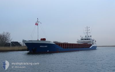
NEULAND
General Cargo
Current Trip
| Time Travelled | 1 day |
|---|---|
| Remaining Time | 1 day |
| Distance Travelled | 317.32 nm |
| Remaining Distance | 388.40 nm |
| AVG Speed | 8.6 Knots |
| MAX Speed | 9 Knots |
| AVG Wind | 8.5 knots |
| MAX Wind | 17.6 knots |
| MIN Temp | 11.6°C / 52.88°F |
| MAX Temp | 21.9°C / 71.42°F |
| Draught | 4.9 m |
| Position Received | Now |
Current Position
| Longitude | 16.00222° |
|---|---|
| Latitude | 55.91533° |
| Status | Under way using engine |
| Speed | 8.5 Knots |
| Course | 258.9° |
| Area | Baltic Sea |
| Station | T-AIS |
| Position Received | Now |
Info
Information
The current position of NEULAND is in Baltic Sea with coordinates 55.91533° / 16.00222° as reported on 2024-06-01 22:32 by AIS to our vessel tracker app. The vessel's current speed is 8.5 Knots and is heading at the port of BRAKE. The estimated time of arrival as calculated by vessel tracking app is 2024-06-03 19:09 LT
The vessel NEULAND (IMO: 9117959, MMSI: 218492000) is a General Cargo that was built in 1995 ( 29 years old ). It's sailing under the flag of [DE] Germany.
In this page you can find informations about the vessels current position, last detected port calls, and current voyage information. If the vessels is not in coverage by AIS you will find the latest position.
The current position of NEULAND is detected by our AIS receivers and we are not responsible for the reliability of the data. The last position was recorded while the vessel was in Coverage by the Ais receivers of our vessel tracking app.
The current draught of NEULAND as reported by AIS is 4.9 meters
Weather
| Temperature | 13.2°C / 55.76°F |
|---|---|
| Wind Speed | 7 knots |
| Direction | 15° NNE |
| Pressure | 1012.1 hPa |
| Humidity | 92 % |
| Cloud Coverage | 44 % |
Featured Company
Last Port Calls
| Port | Arrival | Departure | Time In Port |
|---|---|---|---|
| 2024-05-30 10:46 | 2024-05-31 09:50 | 23 h | |
| 2024-05-28 09:13 | 2024-05-29 09:26 | 1 d | |
| 2024-05-24 19:30 | 2024-05-25 08:18 | 12 h | |
| 2024-05-06 16:53 | 2024-05-24 17:58 | 18 d | |
| 2024-05-05 11:42 | 2024-05-06 15:15 | 1 d | |
| 2024-05-03 06:46 | 2024-05-05 10:23 | 2 d | |
| 2024-04-27 19:28 | 2024-04-30 12:09 | 2 d | |
| 2024-04-24 18:31 | 2024-04-25 04:33 | 10 h | |
| 2024-04-24 16:43 | 2024-04-24 17:11 | 27 m | |
| 2024-04-07 10:51 | 2024-04-24 16:17 | 17 d |
Last Trips
| Origin | Departure | Destination | Arrival | Distance | |
|---|---|---|---|---|---|
| 2024-05-29 12:26 | 2024-05-30 13:46 | 181.95 nm | |||
| 2024-05-25 10:18 | 2024-05-28 12:13 | 552.52 nm | |||
| 2024-05-24 19:58 | 2024-05-24 21:30 | 10.53 nm | |||
| 2024-05-06 17:15 | 2024-05-06 18:53 | 11.71 nm | |||
| 2024-05-05 12:23 | 2024-05-05 13:42 | 11.81 nm | |||
| 2024-04-30 15:09 | 2024-05-03 08:46 | 542.01 nm | |||
| 2024-04-25 06:33 | 2024-04-27 22:28 | 549.34 nm | |||
| 2024-04-24 19:11 | 2024-04-24 20:31 | 7.50 nm | |||
| 2024-04-24 18:17 | 2024-04-24 18:43 | 2.19 nm | |||
| 2024-04-06 15:56 | 2024-04-07 12:51 | 134.38 nm |
Events
| Time | Event | Details | Position / Dest | Info |
|---|---|---|---|---|
| 2024-06-01 18:14 | ETA Changed | 2024/06/04 04:00 2024/06/04 08:00 |
56.24280 / 16.95285
DEBKE
|
Speed: 8.5 kn Course: 234.2° |
| 2024-06-01 18:04 | Status Changed | Under way using engine Default |
56.25682 / 16.98723
DEBKE
|
Speed: 8.5 kn Course: 234° |
| 2024-06-01 17:14 | Status Changed | Default Under way using engine |
56.32692 / 17.16060
DEBKE
|
Speed: 8.6 kn Course: 234.4° |
| 2024-06-01 17:05 | Detected in Sea | Swedish part of the Baltic Sea |
56.33974 / 17.19275
Baltic Sea
DEBKE
|
Speed: 8.6 kn Course: 234.5° |
| 2024-06-01 17:05 | Status Changed | Under way using engine Default |
56.33974 / 17.19275
DEBKE
|
Speed: 8.6 kn Course: 234° |
| 2024-06-01 17:05 | IN Coverage |
56.33974 / 17.19275
Baltic Sea
DEBKE
|
Speed: 8.6 kn Course: 234.5° |
|
| 2024-05-31 18:34 | Status Changed | Default Under way using engine |
57.82834 / 22.50500
DEBKE
|
Speed: 8.3 kn Course: 313.8° |
| 2024-05-31 17:46 | OUT of Coverage |
57.83176 / 22.70030
Gulf of Riga
DEBKE
|
Speed: 8.3 kn Course: 313.8° |
|
| 2024-05-31 17:42 | Status Changed | Under way using engine Default |
57.82625 / 22.71140
DEBKE
|
Speed: 8 kn Course: 315° |
| 2024-05-31 17:34 | Status Changed | Default Under way using engine |
57.81167 / 22.73667
DEBKE
|
Speed: 8.4 kn Course: 315.8° |