
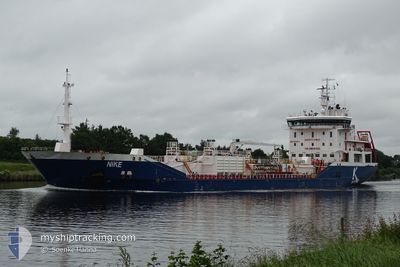
NIKE
Oil/Chemical Tanker
Current Trip
| Trip Time | 17 h, 18 mins |
|---|---|
| Trip Distance | 196.78 nm |
| AVG Speed | 11.2 Knots |
| MAX Speed | 12.4 Knots |
| Draught | 7.5 m |
| AVG Wind | 11.3 knots |
| MAX Wind | 16 knots |
| MIN Temp | 3.8°C / 38.84°F |
| MAX Temp | 10.6°C / 51.08°F |
| Position Received | 3 d ago |
Current Position
| Longitude | 19.02703° |
|---|---|
| Latitude | 60.41595° |
| Status | Under way using engine |
| Speed | 11.3 Knots |
| Course | 4.6° |
| Area | Gulf of Bothnia |
| Station | T-AIS |
| Position Received | 3 d ago |
Info
Information
The current position of NIKE is in Gulf of Bothnia with coordinates 60.41595° / 19.02703° as reported on 2024-05-22 17:24 by AIS to our vessel tracker app. The vessel's current speed is 11.3 Knots and is currently inside the port of LULEA.
The vessel NIKE (IMO: 9431032, MMSI: 249803000) is a Oil/Chemical Tanker that was built in 2009 ( 15 years old ). It's sailing under the flag of [MT] Malta.
In this page you can find informations about the vessels current position, last detected port calls, and current voyage information. If the vessels is not in coverage by AIS you will find the latest position.
The current position of NIKE is detected by our AIS receivers and we are not responsible for the reliability of the data. The last position was recorded while the vessel was in Coverage by the Ais receivers of our vessel tracking app.
The current draught of NIKE as reported by AIS is 7.5 meters
Weather
| Temperature | 6.4°C / 43.52°F |
|---|---|
| Wind Speed | 6 knots |
| Direction | 181° S |
| Pressure | 1029.6 hPa |
| Humidity | 63.1 % |
| Cloud Coverage | 82 % |
Featured Company
Last Port Calls
| Port | Arrival | Departure | Time In Port |
|---|---|---|---|
| 2024-05-25 06:42 | |||
| 2024-05-23 10:07 | 2024-05-24 13:24 | 1 d | |
| 2024-05-19 13:31 | 2024-05-20 08:07 | 18 h | |
| 2024-05-16 09:21 | 2024-05-17 02:15 | 16 h | |
| 2024-05-13 14:36 | 2024-05-14 06:14 | 15 h | |
| 2024-05-09 11:53 | 2024-05-09 13:12 | 1 h | |
| 2024-05-08 13:36 | 2024-05-09 07:16 | 17 h | |
| 2024-05-08 08:33 | 2024-05-08 09:04 | 31 m | |
| 2024-05-02 09:11 | 2024-05-03 16:08 | 1 d | |
| 2024-04-29 04:36 | 2024-04-30 04:22 | 23 h |
Most Visited Ports (Last year)
| Port | Arrivals | |
|---|---|---|
| 17 | ||
| 7 | ||
| 5 | ||
| 4 | ||
| 4 | ||
| 4 |
Last Trips
| Origin | Departure | Destination | Arrival | Distance | |
|---|---|---|---|---|---|
| 2024-05-24 15:24 | 2024-05-25 08:42 | 196.78 nm | |||
| 2024-05-20 10:07 | 2024-05-23 12:07 | 800.63 nm | |||
| 2024-05-17 04:15 | 2024-05-19 15:31 | 150.47 nm | |||
| 2024-05-14 08:14 | 2024-05-16 11:21 | 540.16 nm | |||
| 2024-05-09 15:12 | 2024-05-13 16:36 | 899.11 nm | |||
| 2024-05-09 09:16 | 2024-05-09 13:53 | 47.28 nm | |||
| 2024-05-08 11:04 | 2024-05-08 15:36 | 48.71 nm | |||
| 2024-05-03 17:08 | 2024-05-08 10:33 | 895.90 nm | |||
| 2024-04-30 06:22 | 2024-05-02 10:11 | 491.59 nm | |||
| 2024-04-25 23:12 | 2024-04-29 06:36 | 897.39 nm |
Events
| Time | Event | Details | Position / Dest | Info |
|---|---|---|---|---|
| 2024-05-25 06:48 | STOP Moving |
65.55002 / 22.22809
[SE] LULEA
|
Speed: 0.1 kn Course: 122° |
|
| 2024-05-25 06:42 | PORT ARRIVAL |
|
65.55004 / 22.22750
[SE] LULEA
|
Speed: 1.3 kn Course: 95° |
| 2024-05-24 13:24 | PORT DEPARTURE |
|
63.30971 / 19.14712
SE HUS
|
Speed: 5.8 kn Course: 194° |
| 2024-05-24 13:21 | START Moving |
63.31646 / 19.14954
[SE] HUSUM
|
Speed: 5.8 kn Course: 194° |
|
| 2024-05-23 10:25 | STOP Moving |
63.32126 / 19.15399
[SE] HUSUM
|
Speed: 0.2 kn Course: 161° |
|
| 2024-05-23 10:07 | PORT ARRIVAL |
|
63.31858 / 19.14964
[SE] HUSUM
|
Speed: 2.6 kn Course: 359° |
| 2024-05-22 17:29 | Status Changed | Default Under way using engine |
60.43181 / 19.02951
SE HUS
|
Speed: 11.3 kn Course: 4.6° |
| 2024-05-22 17:24 | OUT of Coverage |
60.41595 / 19.02703
Gulf of Bothnia
SE HUS
|
Speed: 11.3 kn Course: 4.6° |
|
| 2024-05-22 15:52 | Change Sea Area | Swedish part of the Gulf of Bothnia Finnish part of the Gulf of Bothnia |
60.14593 / 19.14823
Gulf of Bothnia
SE HUS
|
Speed: 11.3 kn Course: 321.1° |
| 2024-05-22 13:26 | Change Sea Area | Finnish part of the Gulf of Bothnia Finnish part of the Baltic Sea |
59.79116 / 19.74142
Gulf of Bothnia
SE HUS
|
Speed: 11.5 kn Course: 323° |